 January 10 2018
The notion of low temperatures near or below freezing instead of the entire day staying below that mark is where we are at… and it will be getting warmer. It looks like fog may be a common scene in the mornings as well, especially if you are near the water as we have the warmer air move in.
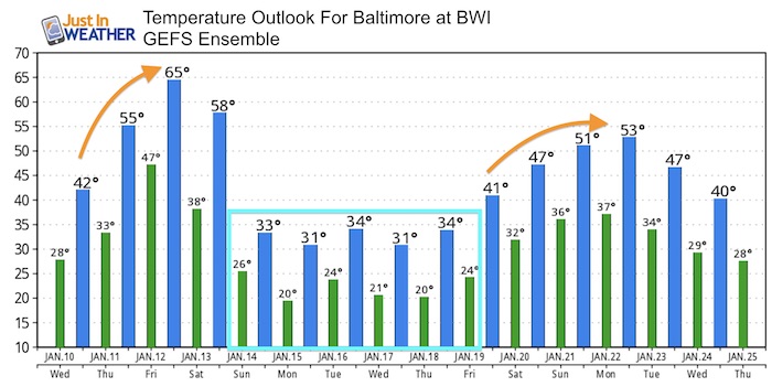
The storm track will shift to our west and bring in a surge of temperatures this week you may not have thought we would see again. Yes, we should reach the 60s by Friday, but it will come with some rain. I want to remind you that the is similar to what happened in January 1996 just one week after the blizzard, there was a surge of heavy rain and warm air that led to flooding. This time, we don’t have the snow pack, but there may be ice jams on the water ways that could clog up.
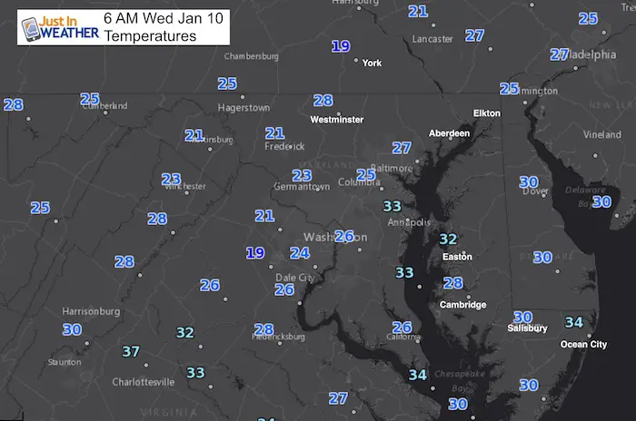
Stats For January 10
Normal High: 41ºF
Record High: 70ºF in 1950
Normal Low: 24ºF
*Former Record Low: -2ºF in 1875
Snow Record: 5.0″ in 1965
Seasonal Snow To Date (at BWI): 5.2″
Sunrise: 7:26 AM
Sunset 5:03 PM
*Daylight = 1:11 longer than yesterday
*Bay Water Temperature = 32ºF at Thomas Pt. Light House.
Keep In Touch All Winter
Click here to sign up for email alerts…. Just in case you don’t get the post on your social media feed
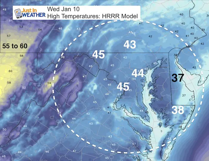
High Temperatures Today
Not as warm as yesterday, but we get back to the mid 40s. Notice the colder air on Delmarva with the influence of deeper snow pack.
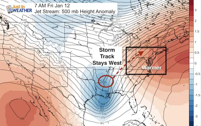
Storm Set Up:
Jet Stream Friday
The warm ridge we will experience this week will move out by Friday, allowing the return flow from the southwest to pump in warmer air. A storm moving through Tennessee to our west will help to bring in the warm air and rain for us.
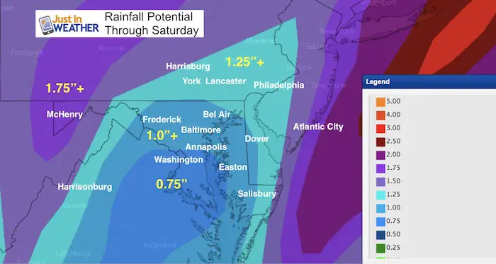
Rai will move in Thursday evening. We should see a break during Friday to enjoy the warm winds, then a second surge of rain Friday night and Saturday. Colder air will follow, which will bring some accumulating snow back to the ski areas between West Virginia, western Maryland, and western PA.
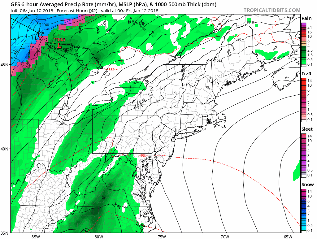
Rainfall Potential
Temperature Outlook
Despite the ice, there is little snow left over in central Maryland and PA. That will allow the warm up to take hold better than I earlier thought. Look closely and you will see that is 65ºF on Friday. That will come with some rain and gusty winds… but I think we get many dry hours in between.
Please share your thoughts, best weather pics/video, or just keep in touch via social media
-
Facebook: Justin Berk, Meteorologist
-
Twitter: @JustinWeather
-
Instagram: justinweather
Shirts
I do these for fun, but also:
A Portion of the proceeds will go to Integrated Wellness programs for Pediatric Oncology Patients
May The Flakes Be With You- Limited Edition Shirt

FITF Gear

Snowstix- We Need You To Measure Snow Too
We are giving 10% of each sale to programs that benefit pediatric oncology patients.

 Get the award winning Kid Weather App I made with my oldest son and support our love for science, weather, and technology. Our 3 year anniversary of the release and our contribution to STEM education is this November. It has been downloaded in 60 countries, and works in both temperature scales. With your support we can expand on the fun introduction to science and real weather.
Keep In Touch All Winter
Click here to sign up for email alerts…. Just in case you don’t get the post on your social media feed
Also See:
My Winter Outlook 2017-2018 for more snow
La Nina Formed: What it could mean to our winter
NOAA Winter Outlook: Not The Best But Not The Worst For Snow
Two Farmers Almanacs Winter 2018 Outlooks
Winter Weather Folkore: Suggestions from Animals and Crops
First Frost and Freeze Dates For Maryland (southern PA and northern VA)
My Preliminary Winter Outlook Notes
Low Snow Winters In Baltimore: To Repeat Or Not Repeat
NOAA Ranks Blizzard 2016 4th Worst Snowstorm On Record
Blizzard 2016 Record Top Snowstorm: Area Totals
Extreme Weather of 2015 balanced out on both ends