 January 5 2018
The storm that rolled up the coast on Thursday January 4 was the media’s exposure to a classic meteorological boom. The pressure level dropped even more than the definition of 24 millibars 24 hours. NOAA measured a pressure drop of 59 millibars in 24 hours, making this the most rapid intensification in the western Atlantic since 1976. The lowest central pressure was 950 mb.
Winds gusted over 50 mph along the coast, and this was a well defined blizzard for many locations. That includes out coastal Maryland and Delaware where nearly a foot of snow fell and snow drifts pushed over 3 feet. See photos below.
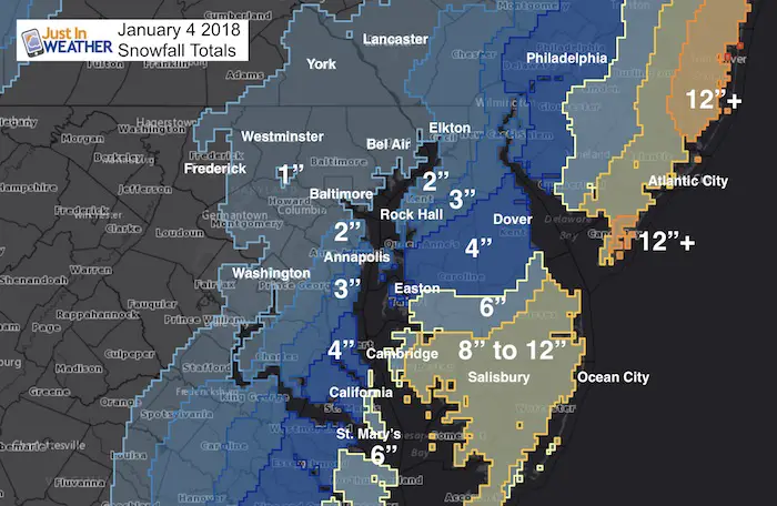
Baltimore’s BWI measured 0.9″ of snow. Just under my initial call, but the blowing wind pushed it all around anyway. Schools were closed and that is the criteria many students and teachers will base my grade on.
Salisbury got 12.5″ and Ocean City measured 11″.
The back edge of any stickage was near Frederick, and the tight gradient of totals was just a little east. The heaviest amounts in Southern Delmarva and Southern Maryland did fall in line with my call. But Cecil and Kent Counties in Maryland were in the lower end and may feel slighted.
Here is a comparison of my forecast map to the snowfall totals confirmed by NOAA. This was not an easy call since it was such a large storm and we were on the edge. I was torn between my Atmospheric Memory of tropical system staying well east and the trend of recent systems staying closer. Overall, I am happy with my call. There were computer models that went much higher with totals, but I stayed the course and it worked out well for most areas. Please check it out and let me know what you think. I grade myself an A- as the timing and general regional call worked out well. The slightly lower metro numbers are within the margin of error for my comfort zone.
My Final Call For Snowfall Map
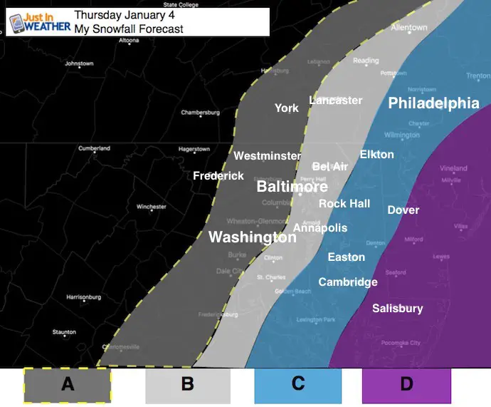
- A: Dusting to 2 Inches
- B: 2 to 4 Inches
- C: 3 to 6 inches
- D: 6 to 12 inches
Snowfall Measured By NWS Spotters
*See town measurement list below
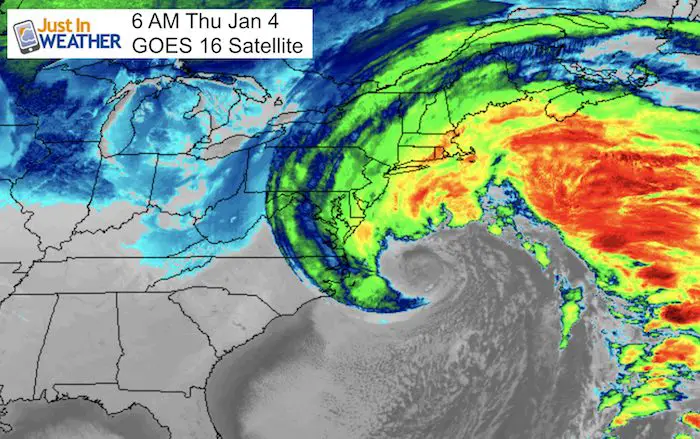
Satellite Loop
This 14 hour look of the new GOES 16 Satellite is simply amazing. Watch the intensity of the core Low off of the Mid Atlantic coast and what appears to be an eye. This is not a tropical system, but does have a warm core trapped in the middle of colder air. The contrast is what made this so impressive.
Shirts:
I see these for fun, but also:
A Portion of the proceeds will go to Integrated Wellness programs for Pediatric Oncology Patients
Faith in DE Flakes
I survived the Blizzard of 2018- Special Edition shirt for Delaware. Sussex County was the big snow winner. See the snow measurements below.
May The Flakes Be With You

Snowfall Measurements: Maryland
********************STORM TOTAL SNOWFALL********************

LOCATION          STORM TOTAL     TIME/DATE   COMMENTS
                     SNOWFALL           OF
                     /INCHES/   MEASUREMENT

DISTRICT OF COLUMBIA

...District Of Columbia...
   1 E Washington         0.8   650 AM  1/04  Trained Spotter
   1 WSW National Zoo     0.6   845 AM  1/04  Trained Spotter
   1 WSW National Arbor   0.5  1007 AM  1/04  Trained Spotter

MARYLAND

...Anne Arundel County...
   2 NW Riva              2.5  1036 AM  1/04  Trained Spotter
   1 NW Herald Harbor     2.5   845 AM  1/04  Trained Spotter
   3 SSW Crownsville      2.3   630 AM  1/04  Trained Spotter
   4 W Annapolis          2.2   720 AM  1/04  Other Federal
   1 SSE Crofton          2.1   750 AM  1/04  NWS Employee
   1 S Annapolis          2.0   745 AM  1/04  Trained Spotter
   1 WNW Odenton          1.8   730 AM  1/04  Trained Spotter
   Bwi Airport            0.9   700 AM  1/04  Airport

...Baltimore County...
   2 E Perry Hall         1.5   925 AM  1/04  Trained Spotter
   Reisterstown           1.0   824 AM  1/04  County Emrg Mgmt
   1 W Parkton            0.7   835 AM  1/04  Trained Spotter

...Baltimore City...
   SE Pimlico             0.5  1000 AM  1/04  Trained Spotter
   2 SE Pikesville        0.4   900 AM  1/04  CoCoRaHS

...Calvert County...
   1 S Prince Frederick   5.0  1045 AM  1/04  Trained Spotter
   2 SW Huntingtown       4.5  1020 AM  1/04  Trained Spotter
   3 WSW Plum Point       3.6  1230 PM  1/04  Trained Spotter
   2 SSW Dunkirk          3.0  1010 AM  1/04  Trained Spotter

...Carroll County...
   NNE Keysville          0.3   700 AM  1/04  Trained Spotter
   NE Oakland             0.3  1030 AM  1/04  Trained Spotter

...Charles County...
   3 NNE Hughesville      3.8   815 AM  1/04  Trained Spotter
   1 SSE St. Charles      3.0   800 AM  1/04  Trained Spotter
   2 W Waldorf            2.8   700 AM  1/04  Trained Spotter
   La Plata               2.5  1226 PM  1/04  Trained Spotter
   2 NE Bryantown         2.2   906 AM  1/04  Trained Spotter
   NW Ripley              1.5   730 AM  1/04  Trained Spotter
   S Marbury              1.0   836 AM  1/04  Trained Spotter

...Frederick County...
   2 NW New Market        0.9   900 AM  1/04  Trained Spotter

...Harford County...
   Whiteford              0.3   105 PM  1/04  Trained Spotter

...Howard County...
   Elkridge               1.2  1207 PM  1/04  NWS Employee
   Columbia               1.0   732 AM  1/04  NWS Employee
   2 N Columbia           0.6   700 AM  1/04  Trained Spotter
   2 E Ellicott City      0.3  1126 AM  1/04  Trained Spotter

...Montgomery County...
   3 SSW Damascus         1.1   857 AM  1/04  Co-Op Observer
   1 NNE Washington Gro   1.0  1000 AM  1/04  Trained Spotter
   1 ESE Montgomery Vil   0.9  1100 AM  1/04  CoCoRaHS
   2 ESE Germantown       0.7  1045 AM  1/04  Trained Spotter
   1 ESE Norbeck          0.5   700 AM  1/04  Trained Spotter
   1 ESE Takoma Park      0.5   805 AM  1/04  Trained Spotter

...St. Marys County...
   2 W Callaway           6.3   204 PM  1/04  Trained Spotter
   1 NNE Park Hall        6.0  1230 PM  1/04  Trained Spotter
   1 ENE Ridge            5.5   700 AM  1/04  Trained Spotter
   1 NNE Great Mills      5.0   831 AM  1/04  Trained Spotter
   2 W California         4.2   810 AM  1/04  Trained Spotter
   1 SSW Hollywood        4.1  1235 PM  1/04  Trained Spotter
   3 NW California        4.0   816 AM  1/04  Trained Spotter
   1 WSW Oakley           3.8   830 AM  1/04  Trained Spotter
   2 ESE Compton          3.0   857 AM  1/04  Trained Spotter
.Caroline County...
   1 ENE Greensboro       5.7   700 AM  1/05  CoCoRaHS

...Cecil County...
   5 NW Elkton            1.5   700 AM  1/05  CoCoRaHS

...Kent County...
   4 NW Worton            1.0   700 AM  1/04  CoCoRaHS

...Queen Anne`s County...
   Stevensville           4.5   334 PM  1/04  Social Media
   Sudlersville           4.0   509 PM  1/04  Social Media

...Queen Annes County...
   3 S Queenstown         2.5   800 AM  1/04  CoCoRaHS

...Talbot County...
   Saint Michaels         4.5   700 AM  1/05  CoCoRaHS
   1 NNW Easton           3.7   700 AM  1/05  CoCoRaHS
...Dorchester County...
   Cambridge              7.0   858 PM  1/04  Broadcast Media
   3 S Cambridge          6.5  1245 PM  1/04  Public

...Somerset County...
   Eden                  11.5   233 PM  1/04  Trained Spotter

...Wicomico County...
   2 SSW Pittsville      13.0   845 PM  1/04  Public
   1 N Salisbury-Wicomi  12.5   903 PM  1/04  Broadcast Media
   1 SW Salisbury        11.5   859 PM  1/04  Broadcast Media
   Pittsville            11.0   154 PM  1/04  County Official
   Salisbury             10.0   900 AM  1/04  Social Media
   Hebron                 9.0   904 PM  1/04  Broadcast Media
   1 W Parsonsburg        6.4   700 AM  1/04  CoCoRaHS

...Worcester County...
   Ocean City            11.0   108 PM  1/04  Broadcast Media
   Snow Hill             11.0   904 PM  1/04  Broadcast Media
   Ocean Pines            8.7   815 AM  1/04  CoCoRaHS
   4 SE Ironshire         6.0   800 AM  1/04  CoCoRaHS
   3 E Bishopville        5.1   500 AM  1/04  CoCoRaHS
********************STORM TOTAL SNOWFALL********************

LOCATION          STORM TOTAL     TIME/DATE   COMMENTS
                     SNOWFALL           OF
                     /INCHES/   MEASUREMENT

DELAWARE

...Kent County...
   Harrington             5.3   215 PM  1/04  DEOS
   Woodside               5.0   511 PM  1/04  DEOS
   5 WNW Harrington       4.5   300 PM  1/04  Trained Spotter
   Dover                  4.3   510 PM  1/04  DEOS
   1 WSW Clayton          4.0   715 AM  1/05  CoCoRaHS
   Frederica              3.8   512 PM  1/04  DEOS
   Smyrna                 3.1   510 PM  1/04  DEOS
   2 ENE Harrington       3.0   910 AM  1/05  CoCoRaHS
   4 ESE Camden           2.5   800 AM  1/04  CoCoRaHS
   Greenville             2.1   215 PM  1/04  DEOS

...New Castle County...
   Blackbird              3.5   509 PM  1/04  DEOS
   2 WNW Glasgow          3.4   700 AM  1/05  CoCoRaHS
   Port Penn              3.2   509 PM  1/04  DEOS
   Talley Brook           2.8   506 PM  1/04  DEOS
   Glasgow                2.8   508 PM  1/04  DEOS
   Newark                 2.7   507 PM  1/04  DEOS
   Claymont               2.7   505 PM  1/04  DEOS
   2 ESE Barksdale        2.6   800 AM  1/05  CoCoRaHS
   New Castle County Ai   2.6   700 PM  1/04  ASOS/AWOS
   Marshallton            2.4   330 PM  1/04  Trained Spotter
   New Castle             2.3   215 PM  1/04  DEOS
   Prices Corner          2.0   506 PM  1/04  DEOS
   1 W Smith Mill Farms   1.9   945 AM  1/04  DEOS
   Hockessin              1.7   506 PM  1/04  DEOS
   Pike Creek             1.5   449 PM  1/04  Trained Spotter
   2 NW Wilmington        1.5   724 AM  1/04  CoCoRaHS
   4 NNW Middletown       1.2   700 AM  1/04  CoCoRaHS
   2 E Pike Creek         1.1   600 AM  1/04  CoCoRaHS

...Sussex County...
   Stockley              11.4   514 PM  1/04  DEOS
   7 E Selbyville        11.0   600 AM  1/05  CoCoRaHS
   Dagsboro              10.8   514 PM  1/04  DEOS
   Lewes                 10.0   517 PM  1/04  DEOS
   7 ENE Dagsboro         9.7   700 AM  1/05  CoCoRaHS
   Nassau                 9.1   515 PM  1/04  DEOS
   4 NNE Laurel           9.0   800 AM  1/05  CoCoRaHS
   6 W Georgetown         8.5   800 AM  1/05  CoCoRaHS
   Laurel                 8.2   518 PM  1/04  DEOS
   Milton                 7.5  1030 AM  1/04  Trained Spotter
   3 SE Milford           7.0   700 AM  1/05  CoCoRaHS
   Selbyville             7.0   630 AM  1/04  Trained Spotter
   4 SW Lewes             6.9   700 AM  1/04  CoCoRaHS
   Bethany Beach          6.8   514 PM  1/04  DEOS
   7 WNW Sycamore         6.7   700 AM  1/04  CoCoRaHS
   6 WNW Sycamore         6.3   730 AM  1/04  CoCoRaHS
   Seaford                6.0   700 AM  1/05  CoCoRaHS
   Ellendale              5.0   515 PM  1/04  DEOS
   Bridgeville            4.1   517 PM  1/04  DEOS
   4 E Delmar             4.0   700 AM  1/04  CoCoRaHS
   Seaford SW             3.8   700 AM  1/04  CoCoRaHS
Keep In Touch All Winter
Click here to sign up for email alerts…. Just in case you don’t get the post on your social media feed
Snow Measurement in Ocean City
Love the beach in winter? My friend Sandy Eastridge braves the blizzard to share these
—> slider
[metaslider id=56734]

Please share your thoughts, best weather pics/video, or just keep in touch via social media
-
Facebook: Justin Berk, Meteorologist
-
Twitter: @JustinWeather
-
Instagram: justinweather
FITF Gear

Snowstix- We Need You To Measure Snow Too
We are giving 10% of each sale to programs that benefit pediatric oncology patients.

 Get the award winning Kid Weather App I made with my oldest son and support our love for science, weather, and technology. Our 3 year anniversary of the release and our contribution to STEM education is this November. It has been downloaded in 60 countries, and works in both temperature scales. With your support we can expand on the fun introduction to science and real weather.
Keep In Touch All Winter
Click here to sign up for email alerts…. Just in case you don’t get the post on your social media feed
Also See:
My Winter Outlook 2017-2018 for more snow
La Nina Formed: What it could mean to our winter
NOAA Winter Outlook: Not The Best But Not The Worst For Snow
Two Farmers Almanacs Winter 2018 Outlooks
Winter Weather Folkore: Suggestions from Animals and Crops
First Frost and Freeze Dates For Maryland (southern PA and northern VA)
My Preliminary Winter Outlook Notes
Low Snow Winters In Baltimore: To Repeat Or Not Repeat
NOAA Ranks Blizzard 2016 4th Worst Snowstorm On Record
Blizzard 2016 Record Top Snowstorm: Area Totals
Extreme Weather of 2015 balanced out on both ends