 January 3 2018
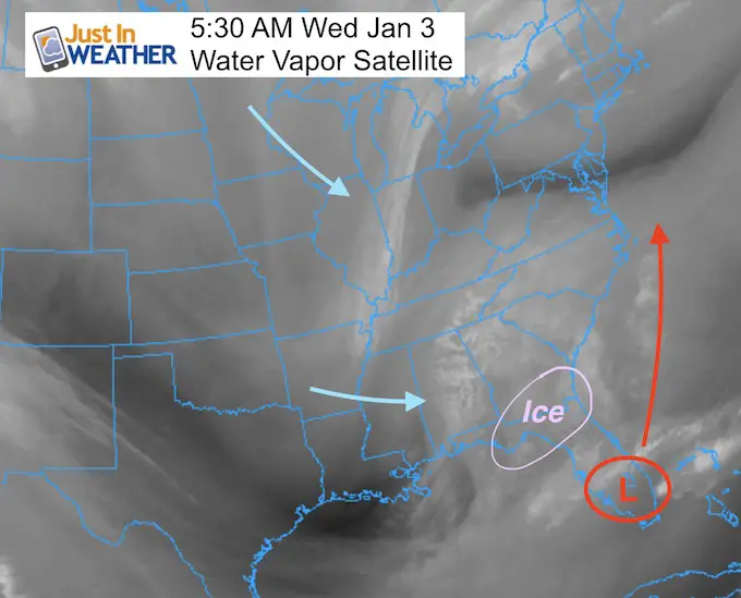
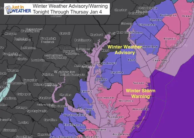
The storm is just forming this morning and already producing freezing rain down to Jacksonville, FL. Today we will watch it develop and track out way with light snow reaching southern Virginia and Maryland by midnight. Then comes the tough part to determine how far west the snow will fall. There is high confidence that moderate snow will fall in southern Maryland and Delmarva through Thursday. Winter Storm Warning and Winter Weather Advisories have been issues, but there will be more snow falling farther north not under any alert at this tine. There is lower confidence on the back end of the snow that may bring some road issues to metro Baltimore. Please see the notes and multiple snow maps below.
Current Warnings and Advisories
Today:
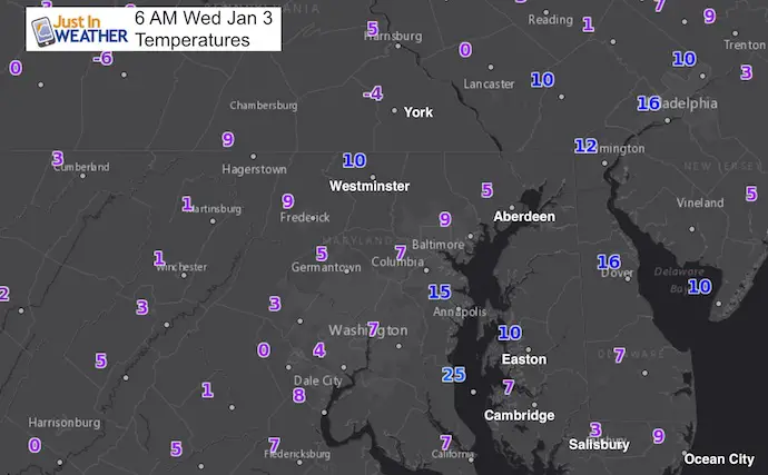
Stats For January 3
Normal High: 42ºF
Record High: 68ºF in 2000
Normal Low: 25ºF
Record Low: 0ºF in 1979
Snow Record: 1.6″ in 1988
Sunrise: 7:26 AM
Sunset 4:56 PM
*Daylight = 47 seconds longer than yesterday
*Bay Water Temperature = 36ºF at Thomas Pt. Light House
Seasonal Snow To Date (at BWI): 4.3″
Keep In Touch All Winter
Click here to sign up for email alerts…. Just in case you don’t get the post on your social media feed

This Morning
This Afternoon
Storm Info
Just Developing This Morning
Snow and ice in northern Florida and Georgia
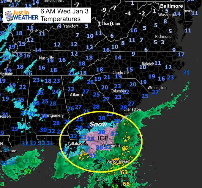
Light snow should move into southern Maryland between 9 PM and Midnight. This will slowly spread north overnight but run into very dry air. So the back edge of the snow will have hard work to break through. Plan on metro snow by daybreak, but we have a wide spread of 3 to 7 AM for it to begin. This will make calls for school and work tough. I will have a better timeline to show in my next post.
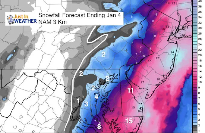
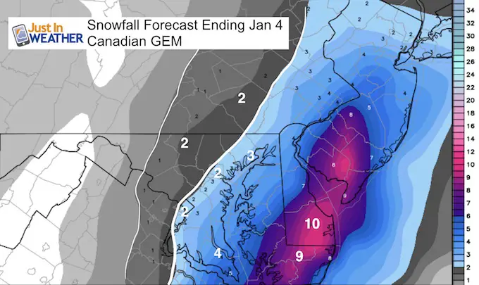
—-> slider: Compare 7 AM The NAM 3Km to GFS and Canadian Models
[metaslider id=56560]
Snow Forecasts
This is my first call snowfall map… I only made some minor adjustments to the coding for each zone. I will have my new call later this morning.
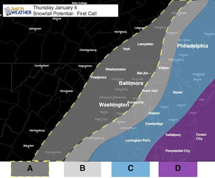
A: Back edge of light snow.
- Dusting to 2 inches (on the high end) possible. Aiming for this to start by daybreak and end early afternoon Thursday.
B: Dusting to 1 to 4 inches
- This is the back edge of where I feel confident the snow will fall with impact. The Bay Bridge may be near the dividing line with more snow south and east. This should begin by 4 AM
C: 4 Inches Or More
- There will be a sharp drop off of snow to the west and big increase to the east. This should begin by midnight.
D: 6 to 12 inches
- There will be places near Salisbury and central Delmarva the get close to a foot of snow. This will being after 8 PM
Computer Model Forecasts
National Weather Service Forecast Maps
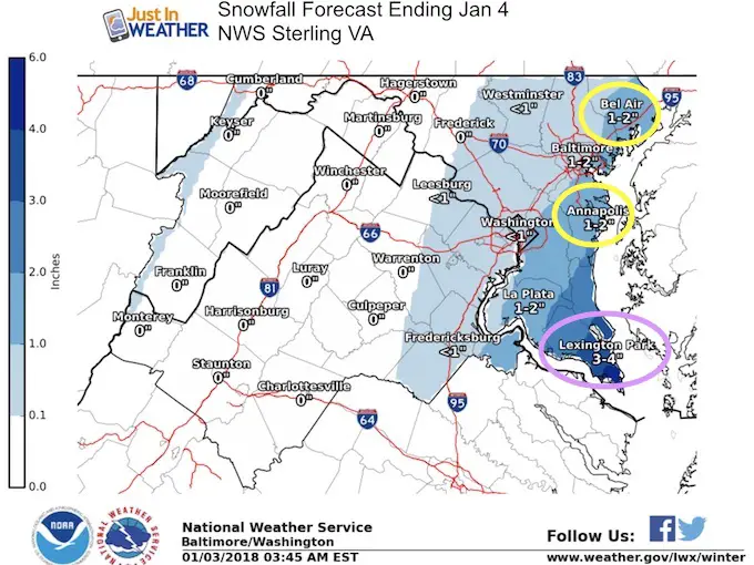
Locally: The Sterling VA Office for Baltimore/Washington has upped the Annapolis total to 1 inch and brought Lexington Park into the 3/4 inch range.
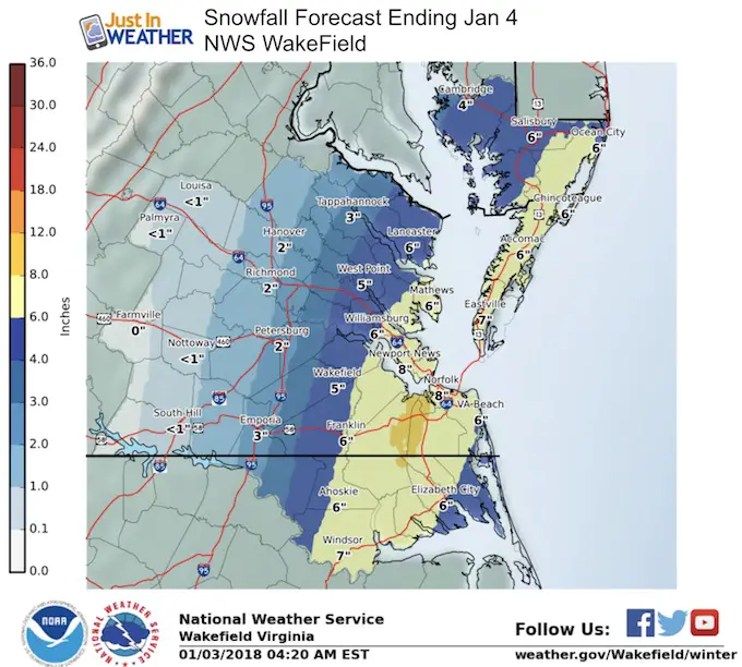
The snow amounts shown for southeast VA to Maryland’s Southern Eastern Shore are form NWS Wakefield VA. This reflects the higher edge but still is conservative compared to some modeling….
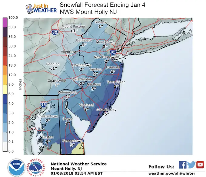
The northern Delmarva forecast comes from NWS Philadelphia out of Mount Holly NJ. This brings Easton , Rock Hall, and Chestertown now in the 2 to 4 inch range.
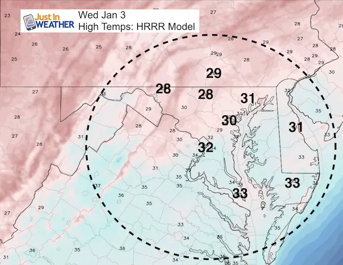
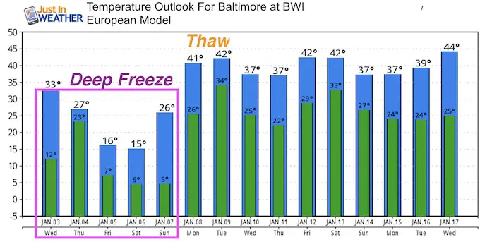
Temperature Outlook
We are promised colder air and stronger winds into the weekend. The ‘thaw’ from this deep freeze should be by Monday next week
Please share your thoughts, best weather pics/video, or just keep in touch via social media
-
Facebook: Justin Berk, Meteorologist
-
Twitter: @JustinWeather
-
Instagram: justinweather
FITF Gear

Snowstix- We Need You To Measure Snow Too
We are giving 10% of each sale to programs that benefit pediatric oncology patients.

 Get the award winning Kid Weather App I made with my oldest son and support our love for science, weather, and technology. Our 3 year anniversary of the release and our contribution to STEM education is this November. It has been downloaded in 60 countries, and works in both temperature scales. With your support we can expand on the fun introduction to science and real weather.
Keep In Touch All Winter
Click here to sign up for email alerts…. Just in case you don’t get the post on your social media feed
Also See:
My Winter Outlook 2017-2018 for more snow
La Nina Formed: What it could mean to our winter
NOAA Winter Outlook: Not The Best But Not The Worst For Snow
Two Farmers Almanacs Winter 2018 Outlooks
Winter Weather Folkore: Suggestions from Animals and Crops
First Frost and Freeze Dates For Maryland (southern PA and northern VA)
My Preliminary Winter Outlook Notes
Low Snow Winters In Baltimore: To Repeat Or Not Repeat
NOAA Ranks Blizzard 2016 4th Worst Snowstorm On Record
Blizzard 2016 Record Top Snowstorm: Area Totals
Extreme Weather of 2015 balanced out on both ends