 January 2 2018
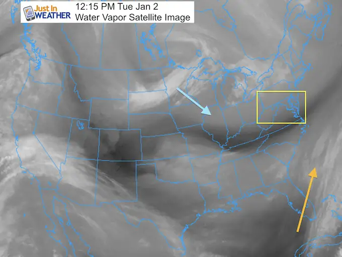
This evening update shows that one thing many have wanted, and some have been afraid to hear. The models appear to showing a shift of the coastal storm track to the west. But, the storm HAS NOT EVEN FORMED YET! The ingredients are coming together from thousands off miles apart to join forced and develop the start of wintry weather Wednesday morning over north Florida. We know the storm will form an be a beast. But precisely where it will develop and move is the tough part of this forecast.
I have been torn between my Atmospheric Memory theory keeping this storm farther off the coast and the recent trend of southern storms in December that have verified a little farther north. This is what I mentioned in my prior post, and now there is support to show that adjustment of only 50 to 100 miles closer with results of snow that are rather dramatic for some.
This reminds me of the January 25th, 2000 storm that featured the new NWS Cray Supercomputer and modeling showing the storm moving off of the coast. I saw the hint that there may be a coastal hugger at play and went on TV with a forecast for Annapolis of ‘Flurries or A Foot?” Yes, my News Director was not happy. But it was the first mention of snow for anyone west of the bay. Needless to say, Baltimore ended up with 18 inches of fluff and thunder snow.
I am NOT suggesting that is the case here, but I am aware of the subtle things to search for and stay a step ahead. My initial call has not changed.. yet.
Please compare to my prior post if you want to see the model adjustments… My First Call For Snowfall January 3 and 4
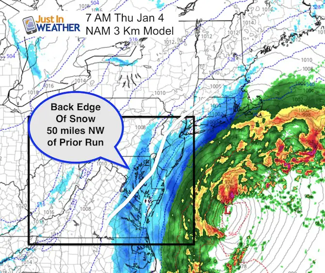
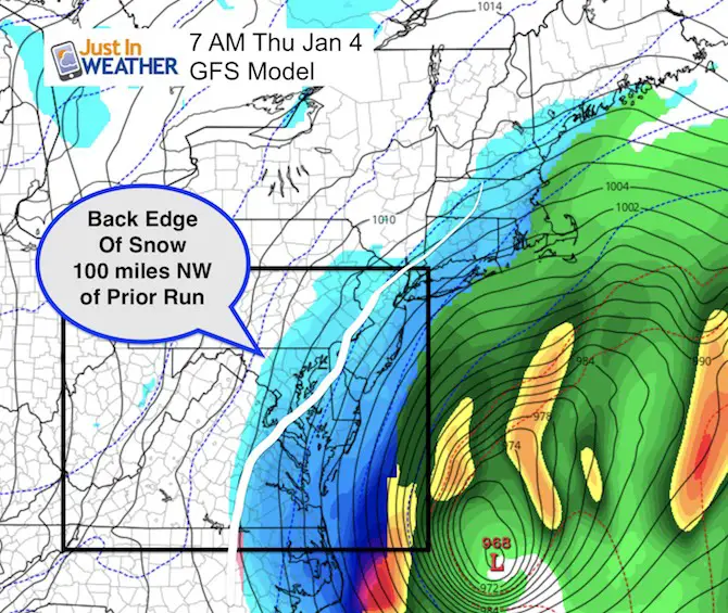
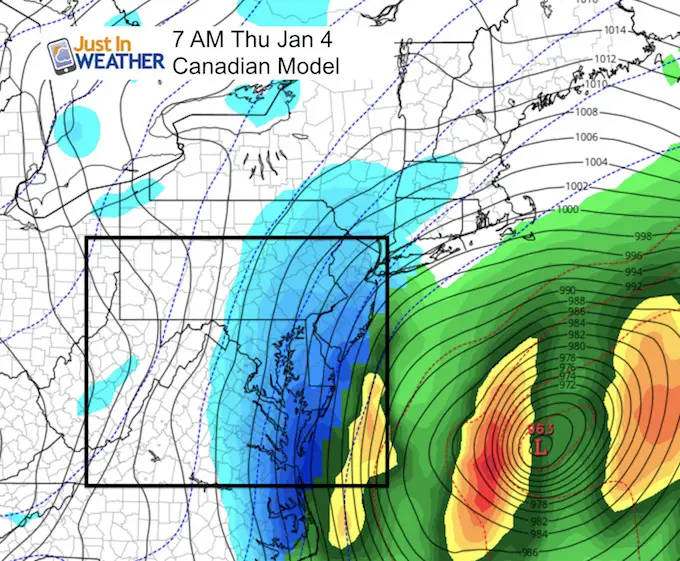
Below are a comparison of three computer models wth their forecast plot for 7 AM on Thursday morning, the closest approach for our region. Then compare my first call for snowfall to the computer model projections and forecast maps from regional National Weather Service offices.
To save time, I am skipping the set up and jumping right into prime time for this event for us. Note, the snow should begin to overspread the region overnight Wednesday and peak around 7 AM Thursday morning.
Thursday Morning at 7 AM
Again, the storm has NOT formed yet. So the region where it develops is broad based, and the track will be easier when we have a surface Low to plot.
NAM 3 Km Model
This has been a good performer with the snow events we had in December. This shows the shift of 50 miles northwest. The snow sharply cutting off near Baltimore/I-95.
GFS Model
This shift is more dramatic, about 100 miles to the northwest. This brings light snow or flurries into the northern Baltimore suburbs… But accumulating snow possible near I-95, Annapolis, and definitely southern Maryland and Delmarva!
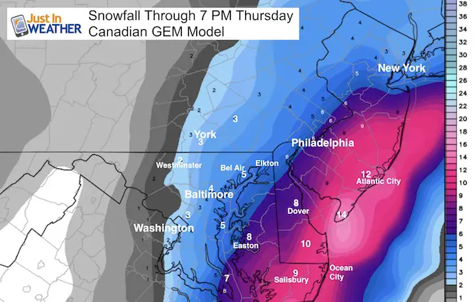
Canadian GEM
This model often performs best in arctic patterns. It was the first to show this storm, and first to push it off of the coast. Now it leads the charge to bring it west…
This is the same image I showed in my prior report since there was no update since the morning run….
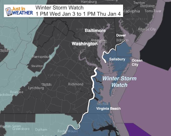
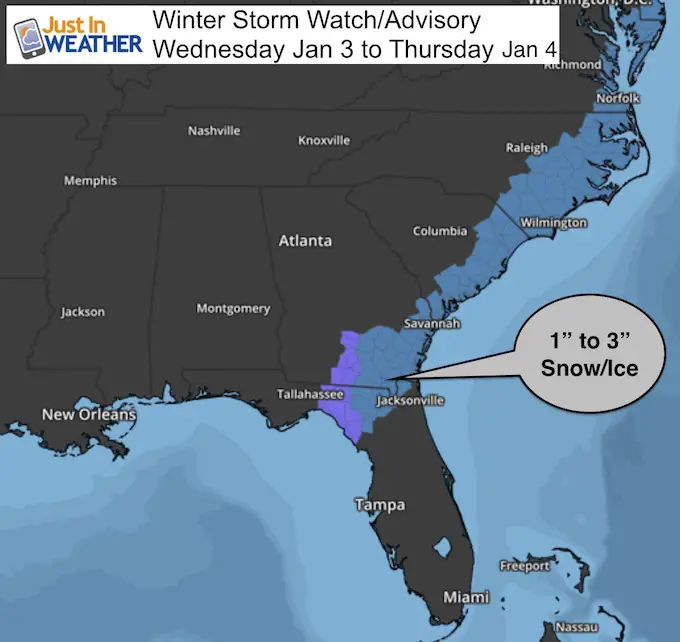
Reminder of Current Local Watches
Upgrading to ‘Warnings’ on Delmarva and adding Advisories from NWS farther north may happen this evening.
How Much Snow?
My First Call
- I am showing my call first in this section. Please use this as guidance for the LOW END CONFIDENCE NUMBER.
- This is what I posted earlier and have not made any changes (yet).
- It is human nature to see the higher numbers and lock on them. I am hesitant to go there since there is such a sharp cut off..
- There will be a sharp drop off of snow on the west end. The dotted yellow lines show the region I still think had the most wiggle room to possibly get some impact or nothing at all. Annapolis will be on the edge of my confident line to get stickage worthy of an impact Thursday morning. Southern Maryland and Delmarva are in for sure…
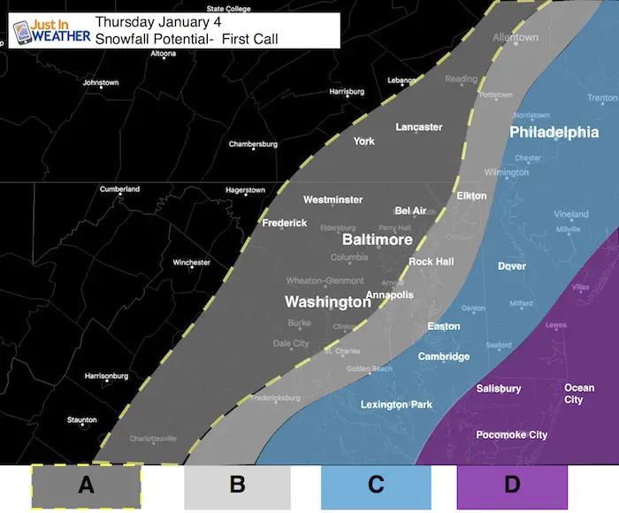
A: Back edge of flurries and light snow.
- IF the storm verifies north as the Canadian Model shows, then this is the region that will have the biggest adjustment entering the storm event.
B: Dusting to 1 inch
- This is the back edge of where I feel confident the snow will fall. The Bay Bridge may be near the dividing line with more snow south and east.
C: 2 Inches Or More
- There will be a sharp drop off of snow to the west and big increase to the east.
D: 4 Inches Or More…
- There is major upside potential for some areas to get in close to double digits.

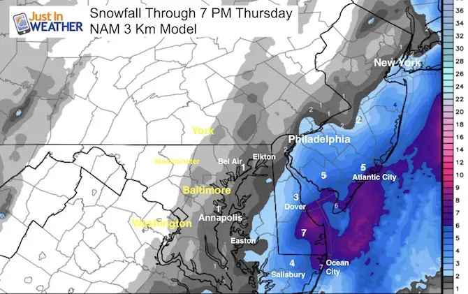
Forecast Model Snow Forecasts
NAM 3 Km Snow Forecast
This is very aggressive for coastal areas. Notice the sharp drop off of snow to the west. This now shows 1 inch for Annapolis
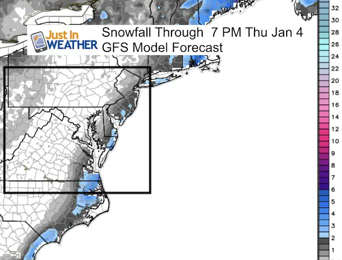
GFS Snow Forecast
This product has not shown snow very well this season. The coastal areas here are seen with 2 to 5 inches. Also seen here is the sharp cut off of snow to the west.
Canadian GEM Snow Forecast
This shows a lot of southern and eastern Delmarva with over 8 inches of snow. notice the 2 inch line west to Washington and Frederick, north to York and Harrisburg. If you want snow, you are rooting for this model. It all depends on the storm verifying north when it forms tomorrow.
National Weather Service Forecast Maps
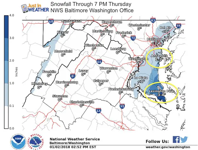
Locally: The Sterling VA Office for Baltimore/Washington has upped the Annapolis total to 1 inch and brought Lexington Park into the 3/4 inch range.
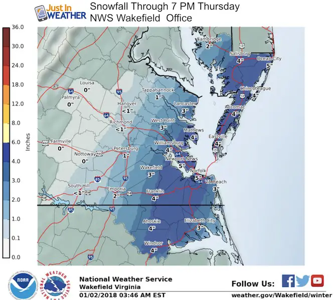
The snow amounts shown for southeast VA to Maryland’s Southern Eastern Shore are form NWS Wakefield VA. This appears to be a little conservative. I did go 45″ or more for Salisbury to Ocean City, but modeling puts them in the 6 to 10 inch range.
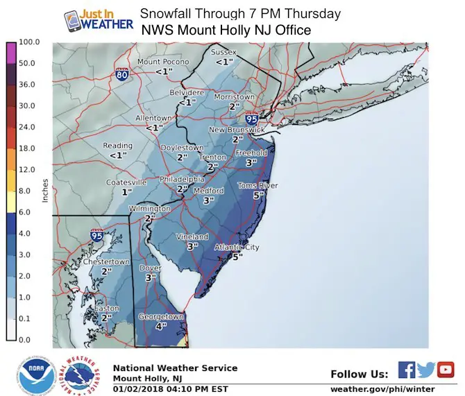
The northern Delmarva forecast comes from NWS Philadelphia out of Mount Holly NJ. This brings Easton , Rock Hall, and Chestertown now in the 2 inch or more range.
Reminder:
This storm has not even formed yet, but we should see snow and ice Wednesday morning way down in northern Florida. The location of the Low Pressure will determine if we get this storm to hug the coast closer or push farther away.
Keep In Touch All Winter
Click here to sign up for email alerts…. Just in case you don’t get the post on your social media feed
Please share your thoughts, best weather pics/video, or just keep in touch via social media
-
Facebook: Justin Berk, Meteorologist
-
Twitter: @JustinWeather
-
Instagram: justinweather
FITF Gear

Snowstix- We Need You To Measure Snow Too
We are giving 10% of each sale to programs that benefit pediatric oncology patients.

 Get the award winning Kid Weather App I made with my oldest son and support our love for science, weather, and technology. Our 3 year anniversary of the release and our contribution to STEM education is this November. It has been downloaded in 60 countries, and works in both temperature scales. With your support we can expand on the fun introduction to science and real weather.
Keep In Touch All Winter
Click here to sign up for email alerts…. Just in case you don’t get the post on your social media feed
Also See:
My Winter Outlook 2017-2018 for more snow
La Nina Formed: What it could mean to our winter
NOAA Winter Outlook: Not The Best But Not The Worst For Snow
Two Farmers Almanacs Winter 2018 Outlooks
Winter Weather Folkore: Suggestions from Animals and Crops
First Frost and Freeze Dates For Maryland (southern PA and northern VA)
My Preliminary Winter Outlook Notes
Low Snow Winters In Baltimore: To Repeat Or Not Repeat
NOAA Ranks Blizzard 2016 4th Worst Snowstorm On Record