 Thursday December 28 2017
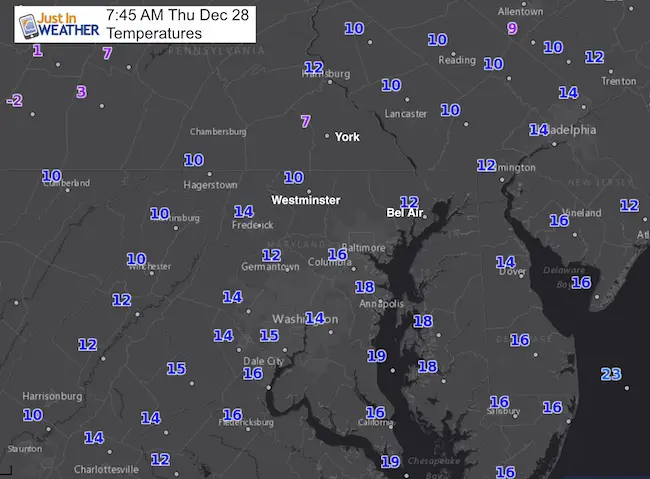
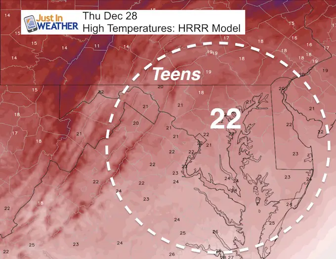
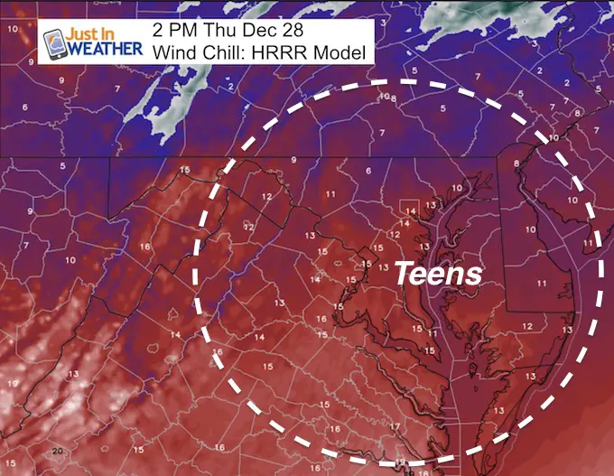
This month and year are going out in style. We are just a few days into a two week stretch of sub freezing temperatures. We did not set a record this morning, but it is cold enough and temps won’t move much today. This is the type of cold that will ice up the Chesapeake Bay likely beyond the Bay Bridge. There is a lot more to go… For starters, today’s Military Bowl in Annapolis will have temperatures in the lower 20s and wind chills in the teens. There is plenty more where that came from. This may further chase people indoors from the Ravens game (later start) and you might want to reconsider any outdoor plans to celebrate New Year’s Eve. In between, the ‘light snow’ event on Saturday is still on, and we may have something next next week. But like the others, I would not get excited about any potential storm that far away.
Here’s the break down:
Stats For December 28
Normal High: 42ºF
Record High: 74ºF in 1946
Normal Low: 26ºF
Record Low: 10ºF in 1950
Snow Record: 2.0″ in 1993
Sunrise: 7:25 AM
Sunset 4:52 PM
*Daylight = 7 seconds longer than yesterday
*Bay Water Temperature = 40ºF at Thomas Pt. Light House
Snow To Date (at BWI): 3.8″
Keep In Touch All Winter
Click here to sign up for email alerts…. Just in case you don’t get the post on your social media feed

Today:
Temperatures are expected to only reach the lower 20s. Here, the focus is on Annapolis for the Military Bowl.
Wind Chills: Teens
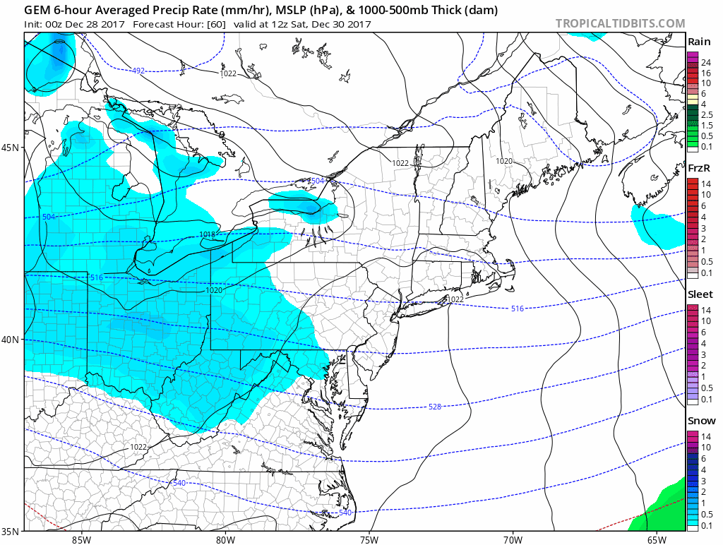
Weekend: Light Snow Saturday
This event has more support to back up this Canadian GEM Model. This looks like a daylight event that has the moisture to produce a dusting to 2 inches. I will have a first call snowfall map later today.
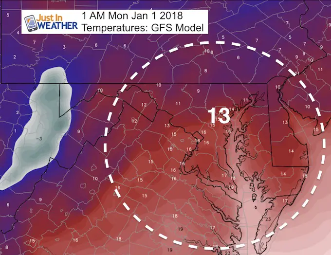
New Year 2018: Re-think Being Outside
This may be the coldest New Year’s Eve in over 50 years. The Baltimore temperatures will be in the lower teens.
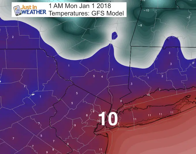
Times Square: Maybe Another Time
The New York City forecast is around 10ºF
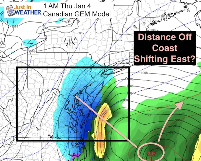
Coastal Storm And Reinforcing Arctic Cold Core:
The final push from this pattern will be next Wednesday and Thursday. This does depend on a possible coastal storm.
I do not want to put much weight in a storm next week. It is too early and I DO NOT trust modeling this season. The Canadian Model here still has it, but shifted the storm 100 miles east in the latest run overnight. The European Model still has a large event for us, but the GFS Model does not even show it forming.
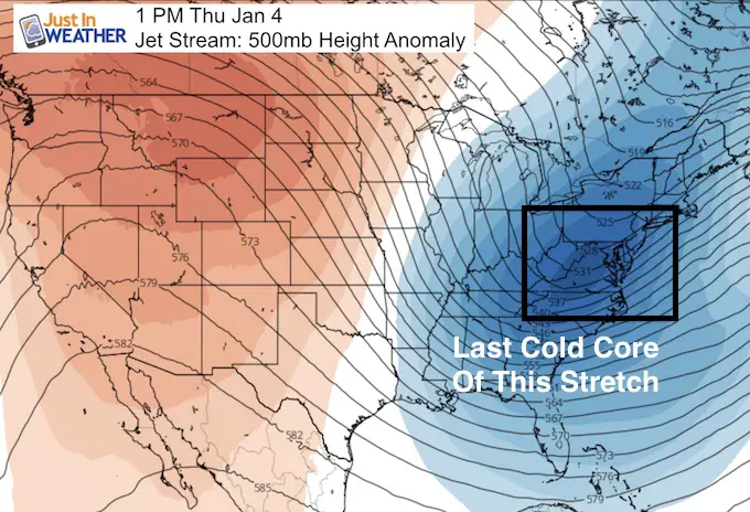
Arctic Cold Core
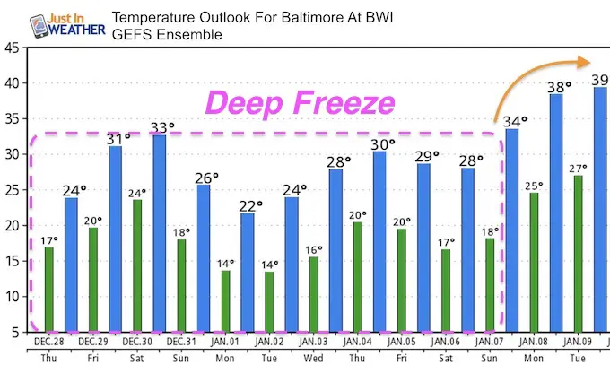
January 4th will be the final push of the arctic air. It will be that cold core that will feed the storm but also determine if it stays close enough or gets pushed off of the coast… Regardless, our sub freezing air stays for the entire first week of January and then some.
Temperature Outlook
Please share your thoughts, best weather pics/video, or just keep in touch via social media
-
Facebook: Justin Berk, Meteorologist
-
Twitter: @JustinWeather
-
Instagram: justinweather
FITF Gear

Snowstix- We Need You To Measure Snow Too
We are giving 10% of each sale to programs that benefit pediatric oncology patients.

 Get the award winning Kid Weather App I made with my oldest son and support our love for science, weather, and technology. Our 3 year anniversary of the release and our contribution to STEM education is this November. It has been downloaded in 60 countries, and works in both temperature scales. With your support we can expand on the fun introduction to science and real weather.
Keep In Touch All Winter
Click here to sign up for email alerts…. Just in case you don’t get the post on your social media feed
Also See:
My Winter Outlook 2017-2018 for more snow
La Nina Formed: What it could mean to our winter
NOAA Winter Outlook: Not The Best But Not The Worst For Snow
Two Farmers Almanacs Winter 2018 Outlooks
Winter Weather Folkore: Suggestions from Animals and Crops
First Frost and Freeze Dates For Maryland (southern PA and northern VA)
My Preliminary Winter Outlook Notes
Low Snow Winters In Baltimore: To Repeat Or Not Repeat
NOAA Ranks Blizzard 2016 4th Worst Snowstorm On Record
Blizzard 2016 Record Top Snowstorm: Area Totals
Extreme Weather of 2015 balanced out on both ends