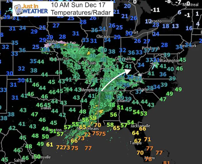
 Sunday December 17 2017
On this date in 1932, Baltimore has 11.5 inches of snow. Most of us have no memory of that, and may feel like this past week of snow will fade in our memories as well. But do not fret, it’s just a blip. Milder air has already moved in as the larger storm track is taking the next Low Pressure center well to our west. This will bring in some rain later today and keep us mild for the net few days. The warm up may end up warmer than models show, which means that we could get near 60ºF, but then chip away. The longer range pattern shows yet another storm ahead of the arctic outbreak to arrive around Christmas. This is still not set in stone, but the holiday may be stormy as winter fights back hard.
Below is a look at the rain timeline today and then the longer range outlook…
Stats For December 17
Normal High: 45ºF
Record High: 68ºF in 1984
Normal Low: 28ºF
Record Low: 5ºF in 1951
Snow Record: 11.5″ in 1932
Sunrise: 7:20 AM
Sunset 4:46 PM
*Bay Water Temperature = 44ºF at Thomas Pt. Light House
Snow To Date (at BWI): 3.8″
Keep In Touch All Winter
Click here to sign up for email alerts…. Just in case you don’t get the post on your social media feed
—-> Slider: Rain Timeline Today
[metaslider id=55881]
High Temperatures
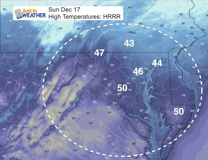

Outlook
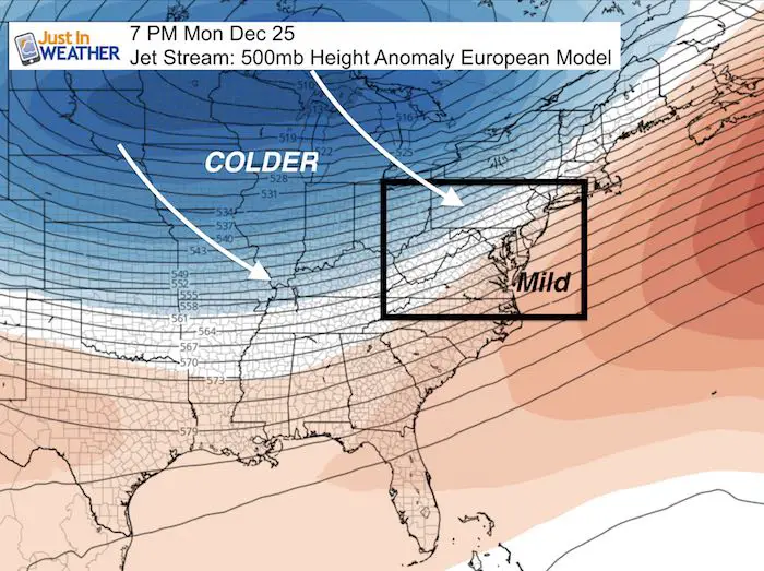
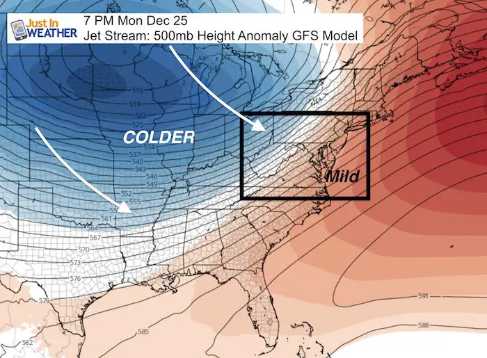
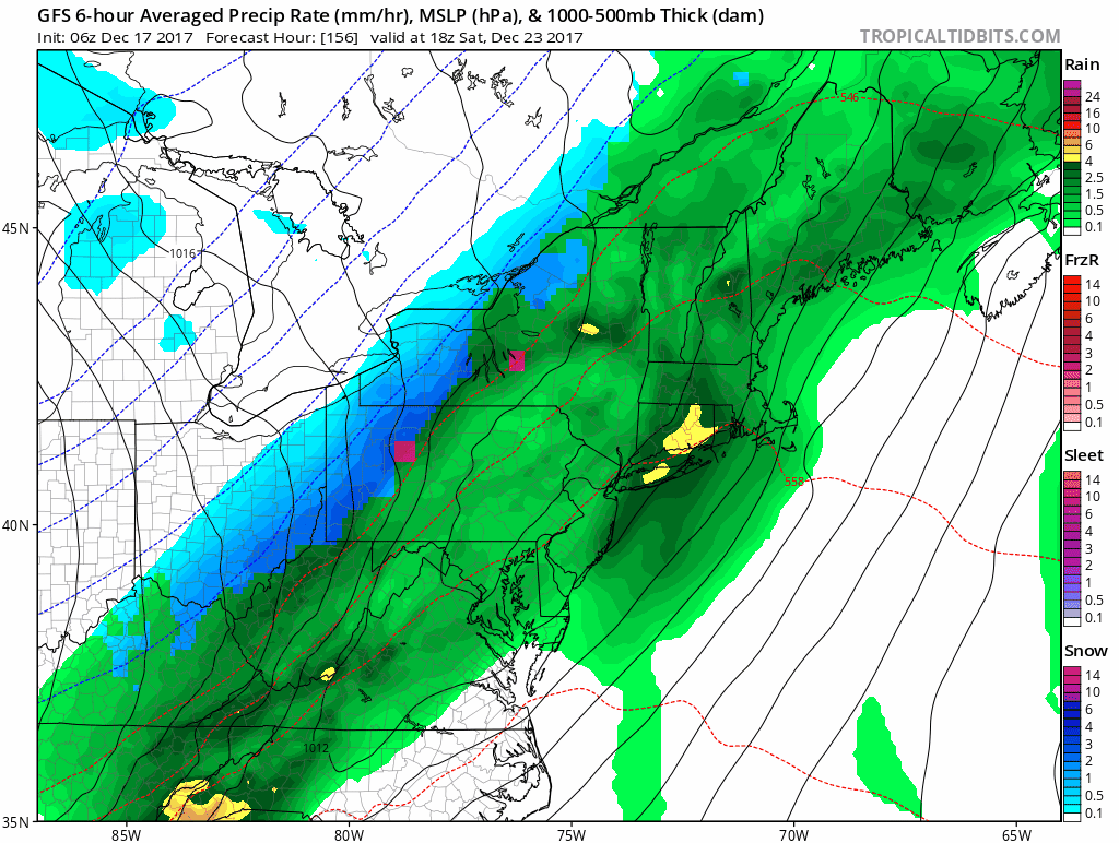
Skipping ahead much of this week, we need to look at the upper level pattern heading into Christmas. We will see a warm up, but the arctic air is recharging and will then charge our way. It is tough to pin down the time it will arrive since this is still 8 days away and the storm track could shift 100 miles east or west. Just remember the last minute adjustments we had to make with the three snow events this past week. So please know this is NOT set in stone and will be shifting in location and time a little. I will track daily to point out the trends…
The European Model is colder/earlier than the GFS here. Both show the transition around Christmas….
Rain/Snow ‘Suggestion’ Animation
Here is a look at the GFS Model bringing in rain and some wintry mix. Remember the European Model is colder and brings that mix into central Maryland….
Please share your thoughts, best weather pics/video, or just keep in touch via social media
-
Facebook: Justin Berk, Meteorologist
-
Twitter: @JustinWeather
-
Instagram: justinweather
FITF Gear
We can promise all apparel orders in by midnight tonight will be delivered before Christmas.

Snowstix- We Need You To Measure Snow Too
We are giving 10% of each sale to programs that benefit pediatric oncology patients.

 Get the award winning Kid Weather App I made with my oldest son and support our love for science, weather, and technology. Our 3 year anniversary of the release and our contribution to STEM education is this November. It has been downloaded in 60 countries, and works in both temperature scales. With your support we can expand on the fun introduction to science and real weather.
Keep In Touch All Winter
Click here to sign up for email alerts…. Just in case you don’t get the post on your social media feed
Also See:
My Winter Outlook 2017-2018 for more snow
La Nina Formed: What it could mean to our winter
NOAA Winter Outlook: Not The Best But Not The Worst For Snow
Two Farmers Almanacs Winter 2018 Outlooks
Winter Weather Folkore: Suggestions from Animals and Crops
First Frost and Freeze Dates For Maryland (southern PA and northern VA)
My Preliminary Winter Outlook Notes
Low Snow Winters In Baltimore: To Repeat Or Not Repeat
NOAA Ranks Blizzard 2016 4th Worst Snowstorm On Record