December 16 2017
The final measurements are in from Friday’s snow. This marks the third event in a week and brings the seasonal total for Baltimore’s BWI up to 3.8″. That is more snow than all of last winter, proving my blanket call that it will snow more. But in all seriousness, this puts us ahead of an average December and the most snow to date since December 2009.
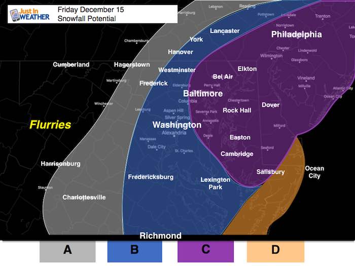
Below is a a map of my forecast, then compare to the snow reports. There were good and bad things about my forecast. The worst part of the day was my website crashing. I sincerely apologize, but have been assured by my web team that the problem has been fixed. As far as my forecast: Please and then give me a grade.
What went right:
The timing of the snow building in the morning and ending for most between 4 and 5 PM
The peak snow time and worst road conditions between 2 and 5 PM. This justified many schools that decided to closer early.
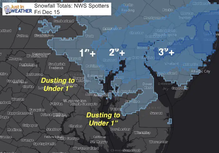
The heaviest snow was on the east side of Baltimore.
My wider snow ranges accounting for the bands and sticking snow. My middle range was a dusting to 2 inches. My big range was between 1 and 3 inches including Baltimore, Harford, and Cecil Counties in Maryland.
What went wrong:
- I had stated ambience snow for metro Baltimore, and that was correct for the morning, but the afternoon ramp up was only a lat call on my part. I hope you saw my report early on Friday in time to prepare.
- The snow needed adjustment in the last day leading up and over performed.
- The snow amounts in Southern Maryland did not stick. That was a poor showing.
- Overall, the timing for the snowfall and poor road conditions worked out as expected, but it was late catching up.
GRADE: I give myself a B. I’d love to hear your thoughts.
My Call For Snowfall:
- A: Back edge of flurries or light snow that may drop of coating.
- B: Between a coating to 2 inches. This depends on where the snow bands set up.
- C: Between 1 to 3 inches. This depends on where the snow bands set up.
- D: May have rain or sleet during the day and change to snow after 3 PM. Snow this evening could drop a coating to 1 inch and lead to slick travel.
Snow Report:

Snow Spotter Reports:
DISTRICT OF COLUMBIA

...District of Columbia...
   Dalecarlia Reservoir   0.5   800 AM 12/16  Co-Op Observer

MARYLAND

...Anne Arundel County...
   Chelsea Beach          0.8   800 AM 12/16  CoCoRaHS
   1 NNE Fort Meade       0.8   700 AM 12/16  CoCoRaHS
   Bwi Airport            0.7   700 PM 12/15  Airport
   3 SW Londontowne       0.6   700 AM 12/16  CoCoRaHS
   1 NW Herald Harbor     0.5   550 PM 12/15  Trained Spotter
   1 SSE Crofton          0.5   537 PM 12/15  NWS Employee
   Ridgeway               0.5   816 AM 12/16  CoCoRaHS
   1 NNE Odenton          0.5   700 AM 12/16  CoCoRaHS
   3 E Laurel             0.4   700 AM 12/16  CoCoRaHS
   Deale                  0.3   700 AM 12/16  CoCoRaHS

...Baltimore County...
   1 NE Kingsville        2.0   458 PM 12/15  Trained Spotter
   Long Green             1.9   700 AM 12/16  CoCoRaHS
   1 NNE Upper Falls      1.8   530 PM 12/15  Trained Spotter
   1 E Kingsville         1.8   430 PM 12/15  CoCoRaHS
   1 N Middle River       1.6   529 PM 12/15  Trained Spotter
   2 ESE White Marsh      1.5   700 AM 12/16  CoCoRaHS
   2 NW Long Green        1.5   400 PM 12/15  Trained Spotter
   1 ENE White Marsh      1.5   450 PM 12/15  Trained Spotter
   2 NE Jacksonville      1.3   834 AM 12/16  CoCoRaHS
   3 NW Long Green        1.2   700 AM 12/16  CoCoRaHS
   1 W Parkton            0.9   915 PM 12/15  Trained Spotter
   2 NNW Brooklandville   0.9   340 PM 12/15  Trained Spotter
   1 E Bentley Springs    0.8   400 PM 12/15  Trained Spotter
   Reisterstown           0.8   506 PM 12/15  County Emrg Mgmt
   1 SW Glyndon           0.5   430 PM 12/15  Trained Spotter

...Baltimore City...
   1 N Hamilton           1.3   600 AM 12/16  CoCoRaHS
   SE Pimlico             1.0   400 PM 12/15  Trained Spotter
   2 ESE Arlington        1.0   700 PM 12/15  Broadcast Media

...Calvert County...
   Dunkirk 3.2nne         0.2   800 AM 12/16  CoCoRaHS
   6 NNE Eagle Harbor     0.2   700 AM 12/16  CoCoRaHS

...Carroll County...
   Gamber                 0.8   700 AM 12/16  CoCoRaHS
   NE Oakland             0.5   330 PM 12/15  Trained Spotter
   1 SE Eldersburg        0.3   400 PM 12/15  Trained Spotter
   3 NE Sykesville        0.3   700 AM 12/16  CoCoRaHS
   3 NE Taneytown         0.1   700 AM 12/16  CoCoRaHS

...Frederick County...
   2 SW Buckeystown       0.5   600 AM 12/16  CoCoRaHS
   Thurmont               0.5   700 AM 12/16  CoCoRaHS
   3 N Thurmont           0.5   700 AM 12/16  CoCoRaHS
   Emmitsburg             0.5   349 PM 12/15  Trained Spotter
   2 NNW New Market       0.3   800 AM 12/16  CoCoRaHS

...Harford County...
   1 W Bel Air            2.0   700 AM 12/16  CoCoRaHS
   1 NNE Bel Air          2.0   510 PM 12/15  Trained Spotter
   1 SW Bynum             2.0   529 PM 12/15  Trained Spotter
   Norrisville            1.4   700 AM 12/16  CoCoRaHS

...Howard County...
   Elkridge               0.8   512 PM 12/15  NWS Employee
   1 W Elkridge           0.6   700 AM 12/16  CoCoRaHS
   1 NW Ellicott City     0.5   521 PM 12/15  Trained Spotter
   1 NNE Laurel           0.5   700 AM 12/16  CoCoRaHS
   2 NNE Laurel           0.5   700 AM 12/16  CoCoRaHS
   1 N Columbia           0.4   700 AM 12/16  CoCoRaHS
   2 N Columbia           0.4   700 AM 12/16  CoCoRaHS

...Montgomery County...
   Damascus 3 Ssw Coop    0.3   700 AM 12/16  Co-Op Observer
   1 W Colesville         0.3   700 AM 12/16  CoCoRaHS
   Poolesville            0.3   800 AM 12/16  CoCoRaHS
   Takoma Park            0.3   700 AM 12/16  CoCoRaHS
   3 SSW Damascus         0.3   641 PM 12/15  Co-Op Observer
   1 ESE Norbeck          0.3   500 PM 12/15  Trained Spotter
   2 SSE Damascus         0.3   630 AM 12/16  CoCoRaHS
   1 SE Olney             0.3   700 AM 12/16  CoCoRaHS
   1 E Aspen Hill         0.2   700 AM 12/16  CoCoRaHS
   1 ENE Montgomery Vil   0.2   500 PM 12/15  Trained Spotter
   1 N White Oak          0.2   700 AM 12/16  CoCoRaHS
   Potomac                0.2   700 AM 12/16  CoCoRaHS
   Montgomery Village     0.2   700 AM 12/16  CoCoRaHS
   Congressional Manor    0.1   700 AM 12/16  CoCoRaHS
   4 NE Leesburg          0.1   800 AM 12/16  CoCoRaHS

...Prince Georges County...
   1 W Tantallon          0.3   700 AM 12/16  CoCoRaHS
   Oxon Hill Coop         0.3   700 AM 12/16  Co-Op Observer
   Oxon Hill              0.3   700 AM 12/16  CoCoRaHS
   Morningside            0.2   700 AM 12/16  CoCoRaHS
   2 E Baden              0.2   700 AM 12/16  CoCoRaHS

...St. Marys County...
   3 NW California          T   200 PM 12/15  Trained Spotter
   California               T   256 PM 12/15  Trained Spotter - Sleet

...Washington County...
   3 NNE Boonsboro        0.2   200 PM 12/15  Trained Spotter
...Caroline County...
   1 ENE Greensboro       0.5   700 AM 12/16  CoCoRaHS

...Cecil County...
   5 NW Elkton            2.3   700 PM 12/15  CoCoRaHS

...Kent County...
   Millington             1.6   805 PM 12/15  Trained Spotter

...Queen Anne`s County...
   Sudlersville           2.0   930 PM 12/15  Social Media

...Talbot County...
   1 SSW Easton           0.5   700 AM 12/16  CoCoRaHS
   1 NNW Easton           0.4   800 AM 12/16  CoCoRaHS
   Saint Michaels         0.2   730 AM 12/16  CoCoRaHS
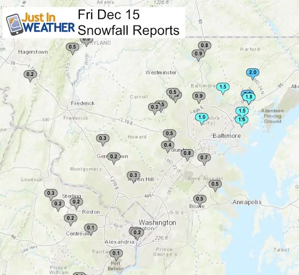
PENNSYLVANIA
York and Lancaster Counties reported between 1 and 1.5 inches
DELAWARE

...Kent County...
   Smyrna                 1.3   830 PM 12/15  DEOS
   2 W Milfrod            1.0   800 AM 12/16  CoCoRaHS
   W Dover                0.8   830 PM 12/15  DEOS
   4 NE Felton            0.7   800 AM 12/16  CoCoRaHS
   Dover                  0.6   830 PM 12/15  DEOS
   Frederica              0.6   830 PM 12/15  DEOS
   2 ENE Harrington       0.5   840 AM 12/16  CoCoRaHS
   Harrington             0.5   830 PM 12/15  DEOS
   5 WNW Harrington       0.5   605 PM 12/15  Trained Spotter
   Woodside               0.4   830 PM 12/15  DEOS

...New Castle County...
   Marshallton            3.2   600 PM 12/15  Trained Spotter
   5 N Newark             3.0   700 AM 12/16  CoCoRaHS
   Brandywine             3.0   610 PM 12/15  Broadcast Media
   Prices Corner          3.0   745 PM 12/15  Trained Spotter
   2 WNW Glasgow          2.4   700 AM 12/16  CoCoRaHS
   2 S Newark             2.4   512 PM 12/15  CoCoRaHS
   Middletown             2.3   347 AM 12/16  Trained Spotter
   Greenville             2.1   830 PM 12/15  DEOS
   New Castle County Ai   2.1   700 PM 12/15  ASOS/AWOS
   Hockessin              2.0   830 PM 12/15  DEOS
   Wilmington Manor       2.0   815 PM 12/15  Social Media
   Newark                 2.0   503 PM 12/15  Trained Spotter
   N Wilmington           2.0   540 PM 12/15  Trained Spotter
   Talley Brook           1.9   830 PM 12/15  DEOS
   Port Penn              1.9   830 PM 12/15  DEOS
   Claymont               1.9   830 PM 12/15  DEOS
   Glasgow                1.7   830 PM 12/15  DEOS
   Blackbird              1.7   830 PM 12/15  DEOS
   2 ESE Barksdale        1.5   750 AM 12/16  CoCoRaHS
   4 NNW Middletown       1.5   700 AM 12/16  CoCoRaHS
   New Castle             1.3   830 PM 12/15  DEOS

...Sussex County...
   3 SE Milford           0.5   700 AM 12/16  CoCoRaHS
   Seaford                0.5   700 AM 12/16  CoCoRaHS
   7 E Selbyville         0.5   600 AM 12/16  CoCoRaHS
   4 SW Lewes             0.3   700 AM 12/16  CoCoRaHS
   4 NNE Laurel           0.3   700 AM 12/16  CoCoRaHS
   7 ENE Dagsboro         0.1   700 AM 12/16  CoCoRaHS
   4 E Delmar             0.1   700 AM 12/16  CoCoRaHS
FITF Gear
We can promise all apparel orders in by midnight tonight will be delivered before Christmas.

Snowstix- We Need You To Measure Snow Too
We are giving 10% of each sale to programs that benefit pediatric oncology patients.

 Get the award winning Kid Weather App I made with my oldest son and support our love for science, weather, and technology. Our 3 year anniversary of the release and our contribution to STEM education is this November. It has been downloaded in 60 countries, and works in both temperature scales. With your support we can expand on the fun introduction to science and real weather.
Please share your thoughts, best weather pics/video, or just keep in touch via social media
-
Facebook: Justin Berk, Meteorologist
-
Twitter: @JustinWeather
-
Instagram: justinweather
Keep In Touch All Winter
Click here to sign up for email alerts…. Just in case you don’t get the post on your social media feed
Also See:
My Winter Outlook 2017-2018 for more snow
La Nina Formed: What it could mean to our winter
NOAA Winter Outlook: Not The Best But Not The Worst For Snow
Two Farmers Almanacs Winter 2018 Outlooks
Winter Weather Folkore: Suggestions from Animals and Crops
First Frost and Freeze Dates For Maryland (southern PA and northern VA)
My Preliminary Winter Outlook Notes
Low Snow Winters In Baltimore: To Repeat Or Not Repeat
NOAA Ranks Blizzard 2016 4th Worst Snowstorm On Record
Blizzard 2016 Record Top Snowstorm: Area Totals
Extreme Weather of 2015 balanced out on both ends