Thursday December 14
This active weather pattern has one more burst of snow up its sleeve. This one will be an upper level feature or jet streak that develops over the areas on Friday. Considering the light snow Wednesday evening that led to numerous school delays this morning… and we are talking about Maryland after all, we need to pay attention to the small events.
Stats For December 13
Normal High: 46ºF
Record High: 71ºF in 2015
Normal Low: 28ºF
Record Low: 11ºF in 1960
Snow Record: 4.2″ in 1951
Sunrise: 7:18 AM
Sunset 4:45 PM
*Bay Water Temperature = 45ºF at Thomas Pt. Light House
Click here to see: The December 9 Snow Report
Keep In Touch All Winter
Click here to sign up for email alerts…. Just in case you don’t get the post on your social media feed
FITF Gear
We can promise all apparel orders in by midnight Friday will be delivered before Christmas.
- Bulk Orders over $299 get 15%- Use Promo Code friendsbofjb
- Free Shipping to orders over $199- Use Promo Code shipmefree
Click here or see the shop below
Satellite: Water Vapor Loop
Active south branch of the jet stream is what is going try to lift back north. At this time it looks like light snow will try to break out on the southern half of our area. This is something that will evolve overhead and be tough to track on the move in until we see it show up on radar.
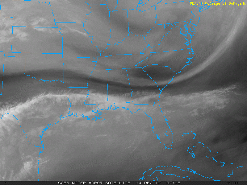
Light snow or flurries will develop around mid day. This will begin in central Virginia and stretch across metro Washington and Baltimore. But most of the action will be south of I-95 into the afternoon, then shift to the Eastern Shore/ Delmarva for the evening. The air temperatures will be flirting with freezing but the daytime sun angle will help roads.
However, should you be in a spot with steady light snow after 4PM, then we could have some road issues into the evening. That includes a rough reference south of The Bay Bridge.
—> slider: Radar Simulation
[metaslider id=55731]
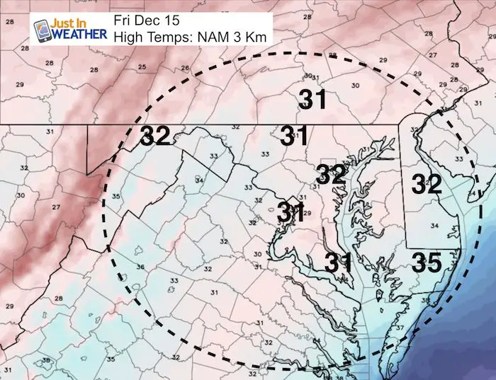
High Temperatures Friday
Faith in the Flakes Online Store
- Bulk Orders over $299 get 15%- Use Promo Code friendsbofjb
- Free Shipping to orders over $199- Use Promo Code shipmefree

Snowstix- We Need You To Measure Snow Too
We are giving 10% of each sale to programs that benefit pediatric oncology patients.

 Get the award winning Kid Weather App I made with my oldest son and support our love for science, weather, and technology. Our 3 year anniversary of the release and our contribution to STEM education is this November. It has been downloaded in 60 countries, and works in both temperature scales. With your support we can expand on the fun introduction to science and real weather.
Please share your thoughts, best weather pics/video, or just keep in touch via social media
-
Facebook: Justin Berk, Meteorologist
-
Twitter: @JustinWeather
-
Instagram: justinweather
Keep In Touch All Winter
Click here to sign up for email alerts…. Just in case you don’t get the post on your social media feed
Also See:
My Winter Outlook 2017-2018 for more snow
La Nina Formed: What it could mean to our winter
NOAA Winter Outlook: Not The Best But Not The Worst For Snow
Two Farmers Almanacs Winter 2018 Outlooks
Winter Weather Folkore: Suggestions from Animals and Crops
First Frost and Freeze Dates For Maryland (southern PA and northern VA)
My Preliminary Winter Outlook Notes
Low Snow Winters In Baltimore: To Repeat Or Not Repeat
NOAA Ranks Blizzard 2016 4th Worst Snowstorm On Record
Blizzard 2016 Record Top Snowstorm: Area Totals
Extreme Weather of 2015 balanced out on both ends