 December 10 2017
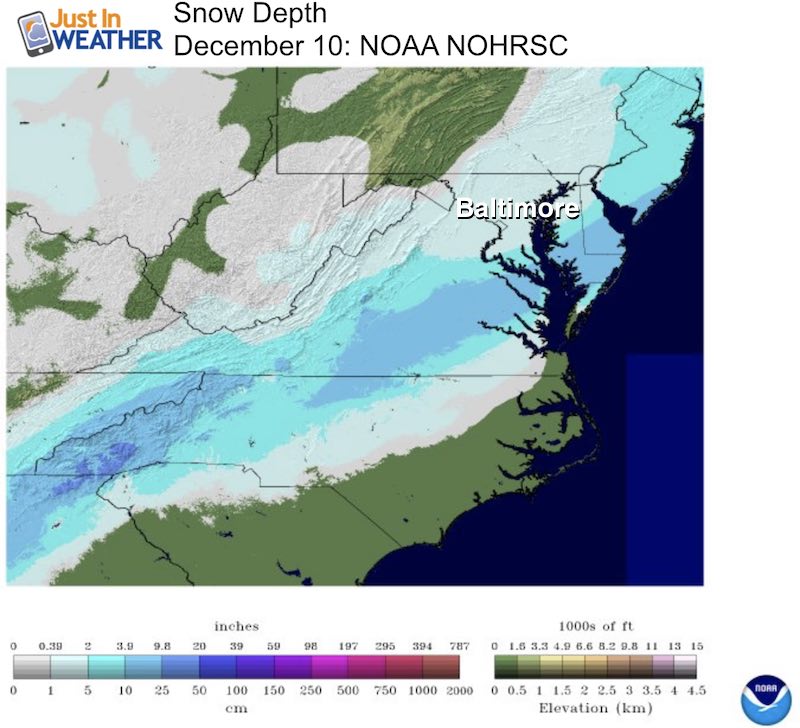
Our first snow storm of the season on December 9 had a slow start, but a strong finish. Here is a compilation of the snow reports around the region along with a comparison to my final snow forecast. The significant notes about this storm are:
- Delayed start until after sunrise. That was four or more hours later that expected.
- Since the snow competed with the sunlight, less could stick early and cut back on early totals.
- The surge of snow in the afternoon made up for lost time with accumulations.
- Late afternoon and evening snow with colder air made for tough travel.
Baltimore’s BWI: 2.8 inches
- This official report from The National Weather Service fit my main call, but fell below my final call of 4 inches.
- This is 0.2 below the entire season total last winter = 3.0 inches
- This is 0.2 average Baltimore December snow total = 3.0 inches
Grade My Forecast
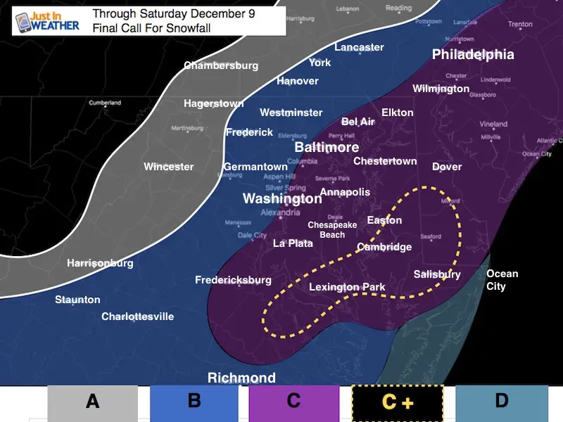
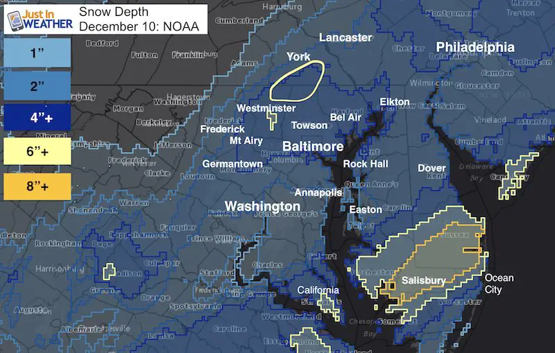
I am putting my map here so you can compare to the larger region map and then read the reports below.
I was cautious with this storm until Thursday. I was conservative with my snow forecast until Friday night after seeing the over-achieving amounts in southern Maryland and lower Eastern Shore. That last bump was a little aggressive, but still fit pretty well.
The delay of the arrival made all the difference with how much stuck early.
What I got right: The wet roads during the day; the snow surge in the afternoon; highlighting for roads developing and more accumulation into the evening.
- Snow amounts north of Baltimore were at or exceeded my forecast.
- Carroll, Northern Baltimore, and Southern York County got 6 to 8 inches. This continues to be an over performing region.
- Highest amounts on the Lower Eastern Shore
What I got wrong: I went agains all of my reports about the warm bay and upped the total snow in the I-95 and Bay areas.
- The Washington to Annapolis portion of Maryland was on the lower end of snow due to the later start time. This was my poorest performing area and deserving of a C-.
If I stayed with my original forecast, this would have been a solid A.
I give my forecast a B
Please share your grade with me and be honest. I know you may grade for you location and not the storm as a whole… but I hope you ended up getting the snowy day you expected after all.
Please share your thoughts, best weather pics/video, or just keep in touch via social media
-
Facebook: Justin Berk, Meteorologist
-
Twitter: @JustinWeather
-
Instagram: justinweather
Official Snow Report: NWS Report Map
These are from NWS Baltimore/Washington
Please note that the other NWS regional offices do not make it easy to see their snow reports in an organized list like this. That limits what I can share at this time.
Maryland: Top part of list
Virginia: Bottom part of list
********************STORM TOTAL SNOWFALL********************

LOCATION          STORM TOTAL     TIME/DATE   COMMENTS
                     SNOWFALL           OF
                     /INCHES/   MEASUREMENT

DISTRICT OF COLUMBIA

...District Of Columbia County...
   1 WSW National Zoo     2.4   901 PM 12/09  Trained Spotter

MARYLAND

...Anne Arundel County...
   1 SSW South Gate       3.5   845 PM 12/09  Trained Spotter
   3 WNW Riveria Beach    3.2  1015 PM 12/09  Trained Spotter
   2 NNE Crofton          3.2   800 PM 12/09  NWS Employee
   1 NW Herald Harbor     3.1   930 PM 12/09  Trained Spotter
   1 NW Annapolis         3.0   800 PM 12/09  Trained Spotter
   Bwi Airport            2.8  1200 AM 12/10  Airport
   Crofton                2.5  1100 PM 12/09  NWS Employee
   2 WSW Harmans          2.0   930 PM 12/09  Trained Spotter

...Baltimore County...
   1 E Bentley Springs    6.0   700 PM 12/09  Trained Spotter
   S Parkton              5.5   700 PM 12/09  Trained Spotter
   1 E Glyndon            5.0   700 PM 12/09  TRAINED SPOTTER
   1 SW Glyndon           5.0   617 PM 12/09  Trained Spotter
   1 WSW Glyndon          4.8   801 PM 12/09  TRAINED SPOTTER
   Reisterstown           4.5   736 PM 12/09  State Emrg Mgmt
   4 N Long Green         4.1   942 PM 12/09  TRAINED SPOTTER
   1 NNE Upper Falls      3.9   914 PM 12/09  Trained Spotter
   1 E Kingsville         3.9   910 PM 12/09  COCORAHS
   2 NW Long Green        3.8   830 PM 12/09  Trained Spotter
   2 NNW Brooklandville   3.8   755 PM 12/09  Trained Spotter
   2 E Perry Hall         3.5   920 PM 12/09  Trained Spotter
   Cockeysville           3.5   711 PM 12/09  Broadcast Media
   1 ENE White Marsh      3.5   855 PM 12/09  Trained Spotter
   1 SSE Catonsville      2.5  1030 PM 12/09  Trained Spotter

...Baltimore City...
   SE Pimlico             3.5   915 PM 12/09  Trained Spotter

...Calvert County...
   2 WNW Huntingtown      3.0   900 PM 12/09  Trained Spotter
   1 S Prince Frederick   2.5   900 PM 12/09  Trained Spotter

...Carroll County...
   2 SE Westminster       6.5   900 PM 12/09  Trained Spotter
   NE Oakland             6.1   640 PM 12/09  Trained Spotter
   1 WNW Gamber           5.7   630 PM 12/09  COCORAHS
   3 SE Winfield          5.4   550 PM 12/09  Trained Spotter
   4 NE Millers           5.0   700 PM 12/09  Co-Op Observer
   SE Westminster         4.5   600 PM 12/09  Trained Spotter
   1 SE Eldersburg        4.3   550 PM 12/09  Trained Spotter
   1 W Westminster        4.0   600 PM 12/09  COCORAHS

...Charles County...
   1 SW Dentsville        2.3   954 PM 12/09  TRAINED SPOTTER
   La Plata               1.8   840 PM 12/09  TRAINED SPOTTER

...Frederick County...
   N New Market           3.0   615 PM 12/09  Trained Spotter
   3 N Thurmont           1.4   630 PM 12/09  Trained Spotter

...Harford County...
   3 W Norrisville        5.5   700 PM 12/09  Trained Spotter
   3 WNW Abingdon         4.0   800 PM 12/09  Trained Spotter
   1 SW Bynum             4.0   911 PM 12/09  Trained Spotter

...Howard County...
   Ellicott City          3.5   828 PM 12/09  Broadcast Media
   2 N Columbia           3.3   847 PM 12/09  TRAINED SPOTTER
   Elkridge               3.3   803 PM 12/09  Other Federal
   1 SSE Simpsonville     3.3   730 PM 12/09  Trained Spotter
   1 NW Ellicott City     3.1   743 PM 12/09  TRAINED SPOTTER
   2 W Elkridge           3.0   910 PM 12/09  Trained Spotter
   2 W Savage             3.0   910 PM 12/09  Trained Spotter
   Columbia               2.0   620 PM 12/09  NWS Employee
   1 ENE Columbia         1.5   917 PM 12/09  Trained Spotter

...Montgomery County...
   Germantown             5.5   610 PM 12/09  Broadcast Media
   3 SSW Damascus         5.2   831 PM 12/09  Co-Op Observer
   1 ESE Clarksburg       4.6   715 PM 12/09  Other Federal
   2 W Derwood            4.4   650 PM 12/09  NWS Employee
   1 ESE Montgomery Vil   4.0   700 PM 12/09  COCORAHS
   Gaithersburg           3.5   714 PM 12/09  County Emrg Mgmt
   Poolesville            3.5   530 PM 12/09  TRAINED SPOTTER
   1 ENE Potomac          3.5   806 PM 12/09  TRAINED SPOTTER
   1 S Olney              3.5  1000 PM 12/09  TRAINED SPOTTER
   1 ESE Norbeck          3.3   800 PM 12/09  Trained Spotter
   1 ENE Montgomery Vil   3.2   830 PM 12/09  Trained Spotter
   1 SSW Montgomery Vil   3.0   700 PM 12/09  Trained Spotter
   1 ENE Garrett Park     2.5   755 PM 12/09  Trained Spotter
   Glen Echo              2.1   838 PM 12/09  NWS Employee

...Prince Georges County...
   1 E Bowie              2.5   630 PM 12/09  COCORAHS
   1 S Forest Heights     1.4   645 PM 12/09  Trained Spotter

...St. Marys County...
   1 ENE Ridge            6.2  1100 PM 12/09  Trained Spotter
   1 NNE Park Hall        5.2   830 PM 12/09  Trained Spotter
   2 WSW Clements         3.0  1100 PM 12/09  Trained Spotter
Snowstix- We Need You To Measure Snow Too
We are giving 10% of each sale to programs that benefit pediatric oncology patients.

Faith in the Flakes Online Store
PJ bottoms still inside out- They have to be to help bring on the snow.

VIRGINIA

...Albemarle County...
   Crozet                 3.0   839 PM 12/09  Trained Spotter
   1 S Boyd Tavern        1.4   600 PM 12/09  Trained Spotter

...Arlington County...
   1 WNW Barcroft         2.3   931 PM 12/09  TRAINED SPOTTER
   Reagan National Airp   2.0   700 PM 12/09  Airport
   1 NNE Westover         1.8   548 PM 12/09  Trained Spotter
   1 S Rosslyn            1.2   715 PM 12/09  Trained Spotter
   2 W Reagan National    1.0   728 PM 12/09  TRAINED SPOTTER

...City of Fairfax...
   1 N Fairfax            2.5  1045 PM 12/09  NWS Employee

...City Of Falls Church County...
   1 W Falls Church       2.2   825 PM 12/09  Trained Spotter

...City of Fredericksburg...
   2 NW Fredericksburg    1.2   800 PM 12/09  TRAINED SPOTTER

...City of Harrisonburg...
   Harrisonburg           2.0   445 PM 12/09  Broadcast Media

...Fairfax County...
   3 N Chantilly          3.6  1030 PM 12/09  NWS Employee
   1 S Centreville        3.5   735 PM 12/09  TRAINED SPOTTER
   2 ENE Herndon          3.2   825 PM 12/09  Trained Spotter
   1 NNE Herndon          3.2   615 PM 12/09  Trained Spotter
   1 NNE Fairfax Statio   3.0   852 PM 12/09  TRAINED SPOTTER
   1 SE Centreville       3.0   922 PM 12/09  TRAINED SPOTTER
   1 SE I66 And I495 In   3.0   900 PM 12/09  NWS Employee
   W Centreville          2.9   915 PM 12/09  Trained Spotter
   1 ENE The I66 And I4   2.4   800 PM 12/09  COCORAHS
   1 SSW Franconia        2.1   900 PM 12/09  Trained Spotter
   1 SSE Dunn Loring      2.0   930 PM 12/09  Trained Spotter
   1 NE The I395 And I4   2.0   826 PM 12/09  TRAINED SPOTTER
   1 SE Langley           1.9   700 PM 12/09  Trained Spotter

...Fauquier County...
   4 SSE Warrenton        3.4   930 PM 12/09  Trained Spotter

...Loudoun County...
   3 WSW Ashburn          4.5   700 PM 12/09  NWS Employee
   Dulles International   4.0   700 PM 12/09  Airport
   2 E Leesburg           3.5   635 PM 12/09  Trained Spotter
   1 ESE Leesburg         3.1   657 PM 12/09  NWS Office
   2 NW Leesburg          3.0   602 PM 12/09  TRAINED SPOTTER
   Purcellville           2.2   647 PM 12/09  NWS Employee
   3 NW Hillsboro         1.8   648 PM 12/09  TRAINED SPOTTER
   1 WNW Lincoln          1.5   430 PM 12/09  Trained Spotter
   1 S Purcellville       1.5   427 PM 12/09  TRAINED SPOTTER

...Orange County...
   Thornhill              2.2   814 PM 12/09  TRAINED SPOTTER
   1 N Flat Run           2.0   450 PM 12/09  Trained Spotter

...Prince William County...
   1 SW Woolsey           5.0   630 PM 12/09  Trained Spotter
   3 N Independent Hill   2.1   801 PM 12/09  Trained Spotter
   1 W Dale City          2.0   828 PM 12/09  TRAINED SPOTTER
   1 E Dale City          1.5   619 PM 12/09  County Emrg Mgmt

...Rockingham County...
   4 ESE Linville         3.3   436 PM 12/09  TRAINED SPOTTER

...Stafford County...
   3 SSE White Oak        2.2   826 PM 12/09  COCORAHS
   1 SSW Spring Valley    2.1  1035 PM 12/09  Trained Spotter
   1 W Ramoth             2.0  1000 PM 12/09  Trained Spotter
   1 SSE Glendie          1.7   829 PM 12/09  TRAINED SPOTTER
   1 ESE Brooke           1.6   820 PM 12/09  Trained Spotter
   5 SSW White Oak        1.6   811 PM 12/09  Trained Spotter
   2 WNW Roseville        1.5   800 PM 12/09  Trained Spotter

...Warren County...
   2 N Linden             3.0   525 PM 12/09  Trained Spotter
   1 ENE Front Royal      2.0   505 PM 12/09  TRAINED SPOTTER
 Get the award winning Kid Weather App I made with my oldest son and support our love for science, weather, and technology. Our 3 year anniversary of the release and our contribution to STEM education is this November. It has been downloaded in 60 countries, and works in both temperature scales. With your support we can expand on the fun introduction to science and real weather.
Also See:
My Winter Outlook 2017-2018 for more snow
La Nina Formed: What it could mean to our winter
NOAA Winter Outlook: Not The Best But Not The Worst For Snow
Two Farmers Almanacs Winter 2018 Outlooks
Winter Weather Folkore: Suggestions from Animals and Crops
First Frost and Freeze Dates For Maryland (southern PA and northern VA)
My Preliminary Winter Outlook Notes
Low Snow Winters In Baltimore: To Repeat Or Not Repeat
NOAA Ranks Blizzard 2016 4th Worst Snowstorm On Record