10 PM Friday December 2017
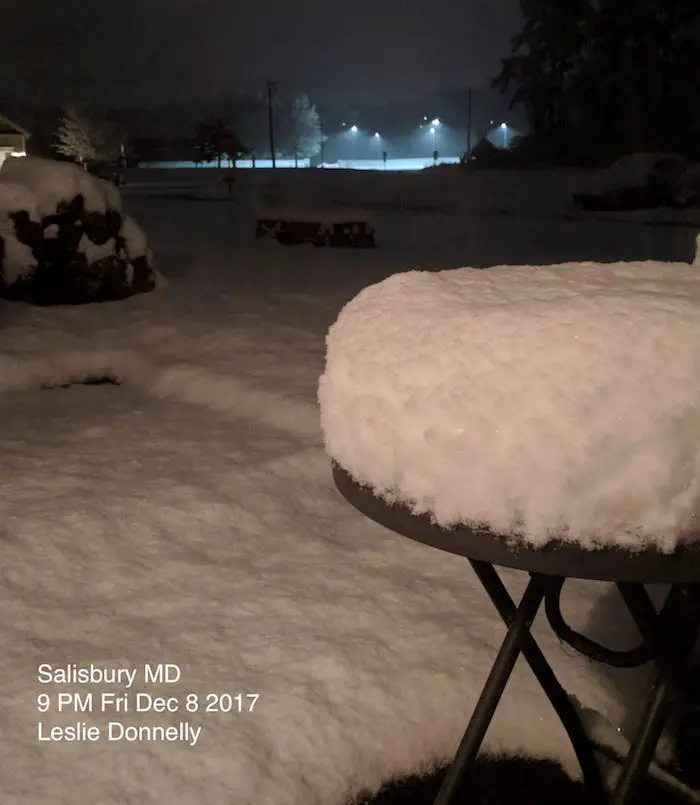
Already an over achiever! This photo from Salisbury at 9 PM already looks like over 6 inches of snow fell. Leslie Donnelly might in the bulls eye, but it definitely will be a spot that gets over 10 inches of snow. when I mentioned that online earlier today, a few scoffed. Its hard to ignore this. The storm has lined up a conveyor belt of moisture that is stretched across southern Maryland and the Delmarva. At this point I don’t care what the models show. It’s all about the radar, surface obs, and photos. But I wanted to update my final map only to match what I have been saying. That includes the doubled digit snow totals and including the north end to York PA.
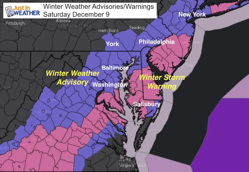
The National Weather Service has expanded the Winter Weather Advisory (finally) for Southern Pennsylvania to include York and Lancaster Counties for 1 to 3 inches of snow. This is a southern storm and the Winter Storm Warning matches up with my snow forecast below.
Keep In Touch All Winter
Click here to sign up for email alerts…. Just in case you don’t get the post on your social media feed.
Doppler Radar at 9:50 PM
This has looked the same for a few hours with the edge of the snow just south of Annapolis, but southern Maryland getting in on the fun. This is the way is was supposed to look as the snow will begin to push north into metro Washington and Baltimore between Midnight and 4 AM.
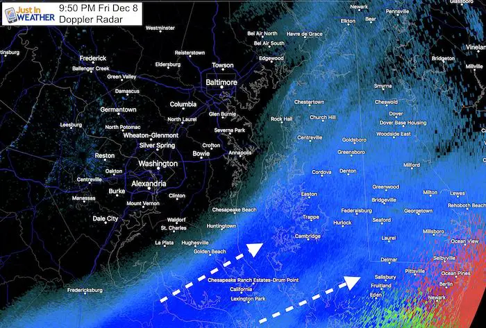
The snow will move back north between midnight and 4 AM. See the radar simulation here.
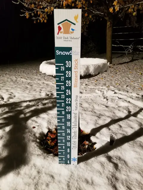
Moderate snow already produced over 3 inches of snow in Leonardtown as of 7 PM as seen below. This is from Barbara Whiskey, owner of Wild Birds Unlimited using a custom SnowStix.
Faith in the Flakes Online Store
PJ bottoms still inside out- They have to be to help bring on the snow.

My Final Snow Map
OK, before you get on my case saying that this doesn’t count since the snow already began…. I was mentioning snow into southern PA to near York on the north end and double digits in Southern Maryland this afternoon. I just realized I needed to update my map here. So let this be the one to grade me by after the storm ends.
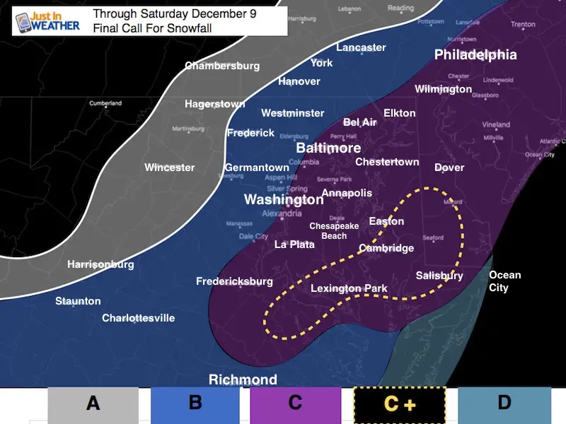
A: Maybe a dusting up to 1 inch
Flurries or light snow on back edge of snow.
B: 1 to 4 inches
This is a wide range, but I needed to break up the lighter snow region versus the main event.
Steady light snow begins before sunrise for most and lasts into the afternoon. It may take a few more hours to get to PA. Roads more likely to be slick through mid day.
C: 4 to 10 inches
This wider range is due to the warming from the Chesapeake Bay. Heaviest snow will fall in this zone and some spots could get more. But the overall range should verify with melting and compacting. Roads will be slick early but may be passable after 9 or 10 AM. More snow will lingering later afternoon and evening on the Delmarva.
C+: (Southern MD and central Delmarva could push 10 inches plus!)
This includes Salisbury
D: Dusting to 3 inches
Coastal areas will be warmer and from rain, then back to snow Saturday afternoon. Most accumulation will be after 3 PM
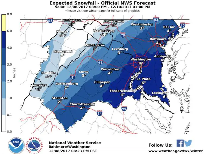
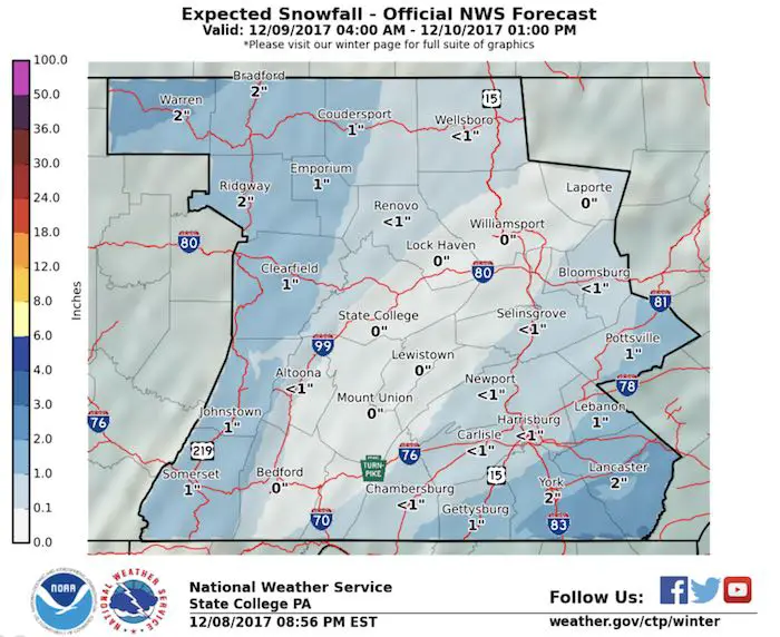
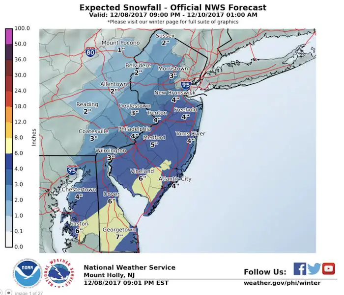
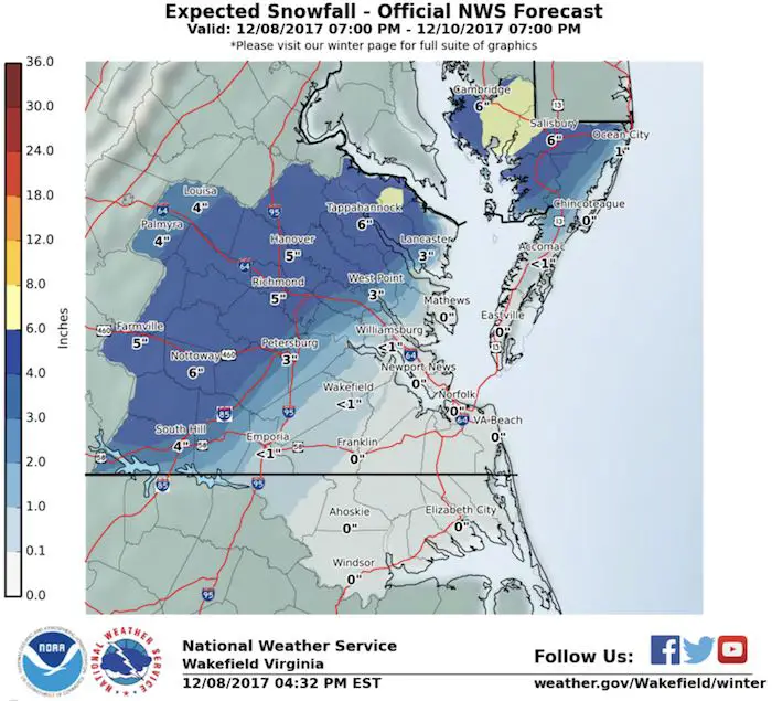
Compare to National Weather Service Updated Snow Maps
Snowstix- New Colors in 30″ and 36″
We are giving 10% of each sale to programs that benefit pediatric oncology patients.

 Get the award winning Kid Weather App I made with my oldest son and support our love for science, weather, and technology. Our 3 year anniversary of the release and our contribution to STEM education is this November. It has been downloaded in 60 countries, and works in both temperature scales. With your support we can expand on the fun introduction to science and real weather.
Please share your thoughts, best weather pics/video, or just keep in touch via social media
-
Facebook: Justin Berk, Meteorologist
-
Twitter: @JustinWeather
-
Instagram: justinweather
Also See:
My Winter Outlook 2017-2018 for more snow
La Nina Formed: What it could mean to our winter
NOAA Winter Outlook: Not The Best But Not The Worst For Snow
Two Farmers Almanacs Winter 2018 Outlooks
Winter Weather Folkore: Suggestions from Animals and Crops
First Frost and Freeze Dates For Maryland (southern PA and northern VA)
My Preliminary Winter Outlook Notes
Low Snow Winters In Baltimore: To Repeat Or Not Repeat
NOAA Ranks Blizzard 2016 4th Worst Snowstorm On Record
Blizzard 2016 Record Top Snowstorm: Area Totals
Extreme Weather of 2015 balanced out on both ends