 Thursday October 12
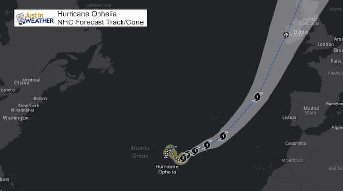
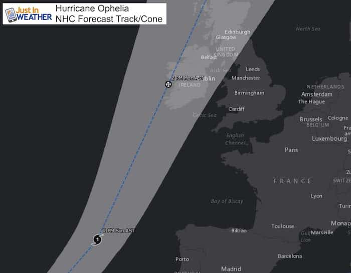
Hurricane Ophelia is in the open water of the central Atlantic where storms don’t normally get attention. Especially in the month of October, when a storm like this would tend to fade away or ride north and weaken. This is very different and already setting records. With winds of 100 mph, this is now a Category 2 hurricane and sitting nearly stationary on the edge of the warm water that can feed it. The forecast takes the track on a fast speed to hit Ireland on Monday between noon and 2 PM local time. It could possibly still remain a hurricane at that time. The strongest winds will be on the east side, so the British Islands will take quite a wallop from this storm.
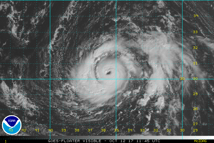
Hurricane Ophelia Visible Satellite Loop
The eye of Ophelia is more vivid and the symmetry looks healthy as the hurricane strengthened today.
There are many things about this storm that make it so unusual. Below are the latest stats and forecast maps. But first…
What Makes Hurricane Ophelia Such A Big Deal:
- 10th hurricane in a row! Each of the last 10 storms reached hurricane intensity. The only other documented times were in 1878, 1886, and 1893 in the pre-satellite era)
- 100 mph winds makes this the strongest October hurricane this far east in the Atlantic. Usually the water is just too cool to support this.
- 1961 was the last time a hurricane hit Europe
- 1987 Great Storm: That was a post tropical storm that hit France and England on Oct 16-17, which would be the same dates Ophelia hits. The highest measured gust of 135 mph was recorded at Pointe Du Roc, Granville, France and the highest gust in the U.K. of 120 mph was recorded at Shoreham-by-Sea.
Food For Thought: Winter Impact?
A strong storm pushing far north in latitude can change the jet stream pattern. This can translate to a shift in ridges and troughs months down the line into winter. Yes, a tropical system into Europe can result in pushing the jet stream farther north in Western Europe, which often is balanced by a trough or cooler pattern on the other side of the Atlantic in Eastern US. Comparing the few analogue years listed above… the resulting winters were near to above normal for the eastern US.
Snow in Baltimore
- 1961-1962 = 35.2″
- 1987-88 = 20.4″
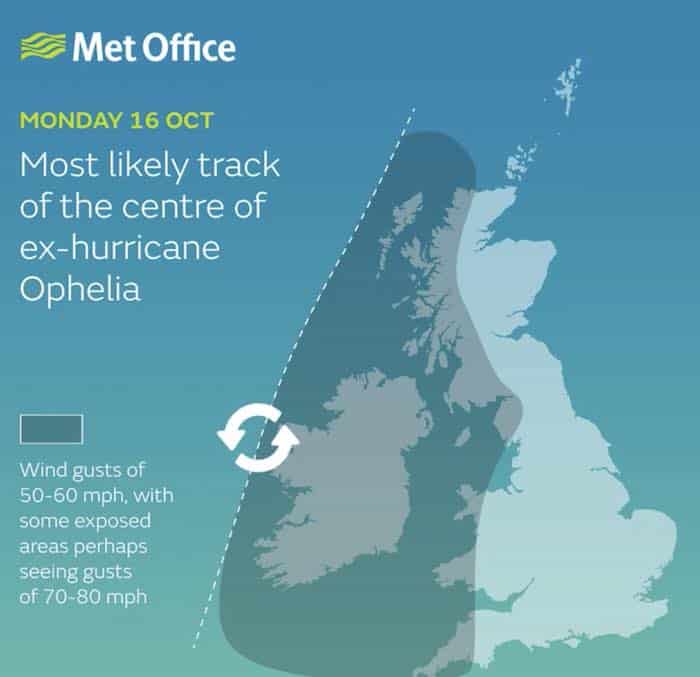
UK Met Office Concerned
UKMET posted this image earlier today… Before Ophelia grew to a Category 2. The forecast to remain a hurricane for landfall changed since this was released. The wind forecast will be adjusted upwards.
Reminder that the strongest winds will be on the east/right side of the center of the storm.
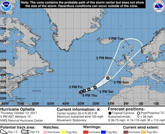
Ophelia Stats from the National Hurricane Center
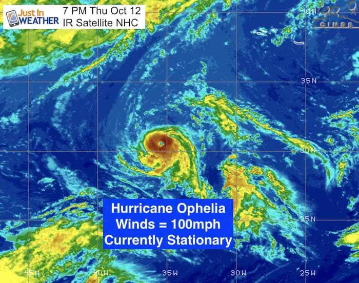
SUMMARY OF 500 PM AST
———————————————-
LOCATION…30.4N 35.5W
ABOUT 715 MI…1150 KM SW OF THE AZORES
MAXIMUM SUSTAINED WINDS…100 MPH…155 KM/H
PRESENT MOVEMENT…STATIONARY
MINIMUM CENTRAL PRESSURE…973 MB…28.74 INCHES
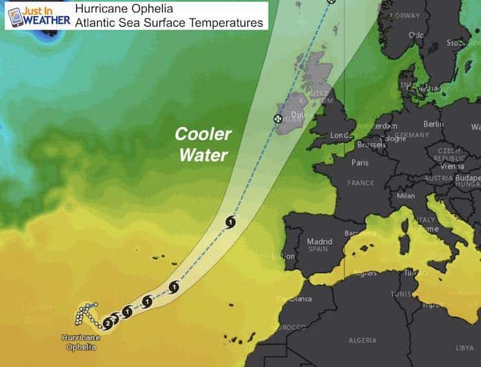
Sea Surface Temperatures
Warm water feeds into tropical storms, This needs to be at least 78ºF. The orange and yellow shades here represent the edge of that warm water. The green shade has temps in the 60s… which will force the storm to weaken. A fast mover is what will allow this to survive the trip as this track places it on Ireland Monday afternoon local time.
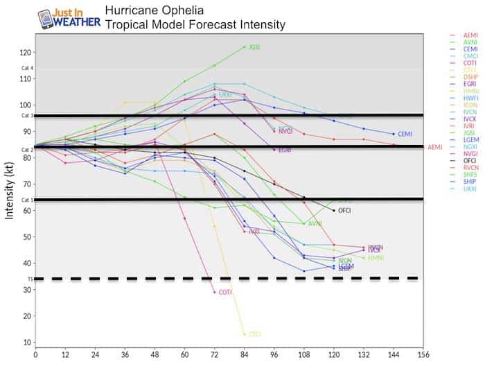
Forecast Model Intensity
There is a good change Ophelia maintains this wind speed, or even grows stronger over the next 48 hours. The models split on further growth or weakening. This will depend on the influence of the cooler water.
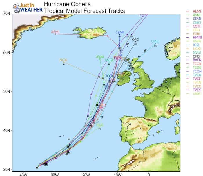
Forecast Model Tracks
I have pointed out the model errors in the hurricanes all season verifying to the east. If so, then the likelihood of an Ireland landfall is pretty high.
European Model Forecast
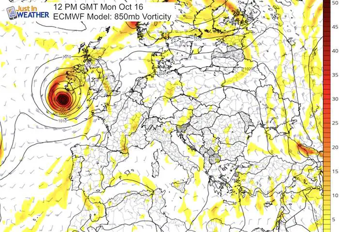
Forecast Track Close
Landfall is forecasted to be between noon and 2 PM local time on Monday October 16. This is the center of the cone of uncertainly, but given the tendency for storms to track to the east of the forecast, the a landfall seems likely.
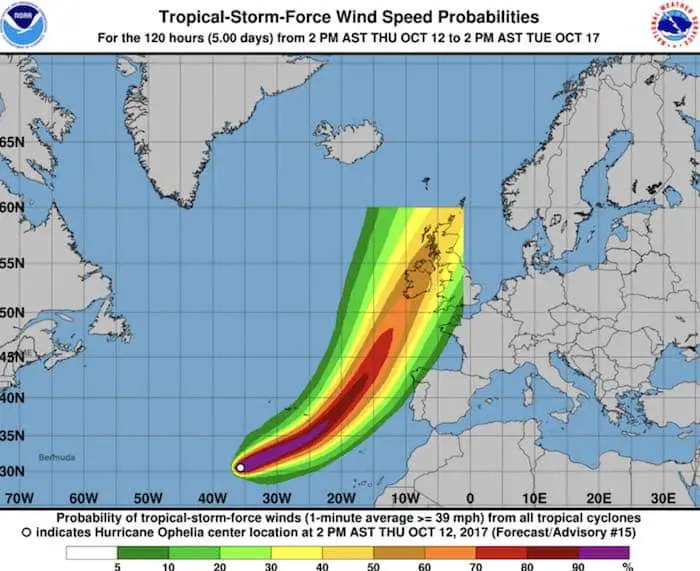
National Hurricane Center Maps
The Tropical Storm Force Wind map shows the edge the zone coverage. This highlights the rare storm we have to experience.
Sign up for email updates on new posts
Since you may miss some posts via social media, click here for email alerts as a way to make sure you don’t miss any. *You may have to refresh that page once for your browser to clear out the images.
Trust in this Bust- Limited Edition Shirt
This is not a forecast, but a fundraiser for breast cancer research at BCRF- the highest rated cancer research charity. This soft Bella T-Shirt is to promote the strength of the ‘good bust’ and the heart that beats strong beneath it. Proceeds will be donated in honor of my mother Linda Berk, a 3-time breast cancer survivor. Click on the shirt image to join us.

Please share your thoughts, best weather pics/video, or just keep in touch via social media
-
Facebook: Justin Berk, Meteorologist
-
Twitter: @JustinWeather
-
Instagram: justinweather