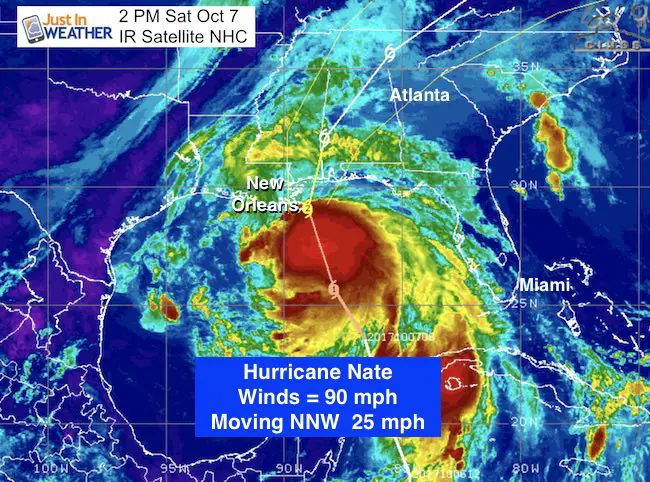
 2 PM Saturday October 7
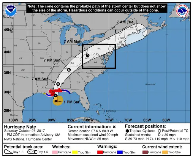
Hurricane Nate now has winds of 90 mph and is continuing to organize. The Gulf of Mexico warm water and lack of wind sheer aloft is allowing the storm to strengthen as it organizes. It should become a Category 2 storm in a few hours, it is just running out of time. The faster forward speed of 25 mph will place it on the shores east of New Orleans tonight. That location will push the worst conditions on the east side with storm surge of 8 to 10 feet in Mississippi and Alabama. The forward speed also means the storm will move farther inland before it weakens.
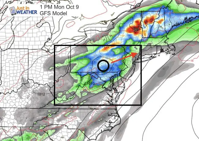
What this means for us in the Mid Atlantic
- A stronger storm will carry more moisture. Heavier rain and more flooding possible.
- A stronger storm will pack faster winds.
- A faster moving storm can push farther inland before weakening. Nate should be downgraded to a Depression on Sunday, but tropical storm force wind gusts (over 40 mph) more likely as the Low passes by.
- There will be a slight risk for severe storms with high wind gusts and an isolate tornado mid day Monday.
- A faster moving storm adjusts the arrival time and the track will be a little farther west of the prior track because the cold front expected to help guide Nate is not in place yet.
*See all the storm graphics below
2 PM EDT Stats
LOCATION…27.6N 88.9W
ABOUT 105 MI…170 KM S OF THE MOUTH OF THE MISSISSIPPI RIVER
ABOUT 195 MI…315 KM S OF BILOXI MISSISSIPPI
MAXIMUM SUSTAINED WINDS…90 MPH…150 KM/H
PRESENT MOVEMENT…NNW OR 340 DEGREES AT 25 MPH…40 KM/H
MINIMUM CENTRAL PRESSURE…982 MB…29.00 INCHES
Warnings and Watches are listed at the bottom of this post
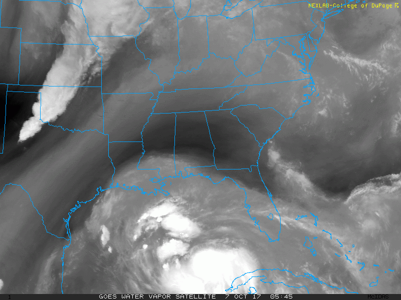
Water Vapor Satellite Loop
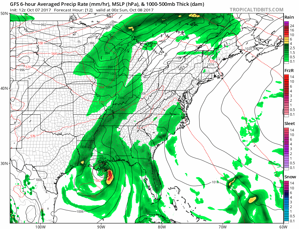
Forecast Animation (GFS Model)
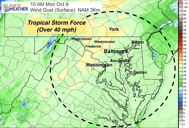
Winds:
The strongest part of the storm is on the east side. Since the Low will track along the mountains, that will keep the threat of the worst conditions between I-81 and I-95. This will bring the risk of severe storms with gusty winds or and isolated tornado Monday mid-day. The fastest winds are likely to be between Frederick and York.
—> slider: Winds Aloft
[metaslider id=53559]
Surface Winds
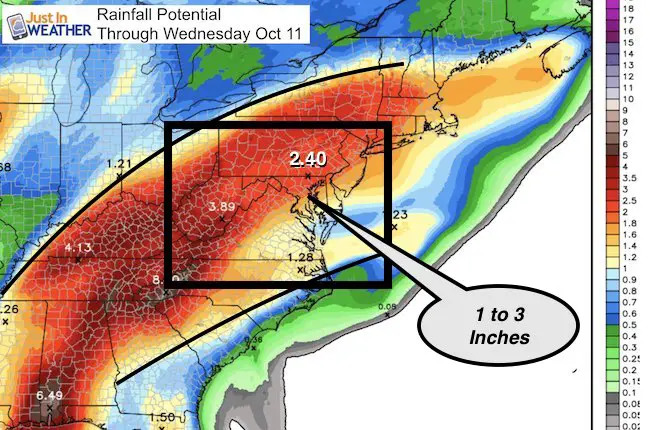
Rainfall = Potential Flooding
 Get the award winning Kid Weather App I made with my oldest son and support our love for science, weather, and technology. Our 3 year anniversary of the release and our contribution to STEM education is this November. It has been downloaded in 60 countries, and works in both temperature scales. With your support we can expand on the fun introduction to science and real weather.
Forecast Track
SUMMARY OF WATCHES AND WARNINGS IN EFFECT:
A Hurricane Warning is in effect for…
* Grand Isle Louisiana to the Alabama/Florida border
* Metropolitan New Orleans and Lake Pontchartrain
A Storm Surge Warning is in effect for…
* Morgan City Louisiana to the Okaloosa/Walton County Line Florida
* Northern and western shores of Lake Pontchartrain
A Tropical Storm Warning is in effect for…
* Lake Maurepas
* West of Grand Isle to Morgan City Louisiana
* East of the Alabama/Florida border to Indian Pass Florida
A Hurricane Watch is in effect for…
* Lake Maurepas
* East of the Alabama/Florida border to the Okaloosa/Walton County
Line
* West of Grand Isle to Morgan City Louisiana
A Storm Surge Watch is in effect for…
* East of the Okaloosa/Walton County Line to Indian Pass Florida
A Tropical Storm Watch is in effect for…
* West of Morgan City to Intracoastal City Louisiana
Trust in this Bust- Limited Edition Shirt
This is not a forecast, but a fundraiser for breast cancer research at BCRF- the highest rated cancer research charity. This soft Bella T-Shirt is to promote the strength of the ‘good bust’ and the heart that beats strong beneath it. Proceeds will be donated in honor of my mother Linda Berk, a 3-time breast cancer survivor. Click on the shirt image to join us.

Please share your thoughts, best weather pics/video, or just keep in touch via social media
-
Facebook: Justin Berk, Meteorologist
-
Twitter: @JustinWeather
-
Instagram: justinweather