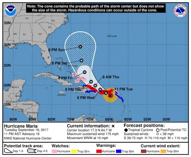
 11 PM Tuesday September 19
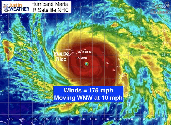
Hurricane Maria has winds of 175 mph and about to strike St. Croix and Puerto Rico. The pressure level of 909 mb makes this among the top 10 storms in the Atlantic basin. The 11 PM Advisory from The National Hurricane Center has not changed. New data from the current Air Force Reconnaissance flight should be in the next 1 to 2 hours and then updated. This is a small storm, however. The eye is only 10 miles across. The hurricane force winds extend 35 miles from the center. So 40 miles away, winds are under 75 mph. The wind damage will be devastating but confined to a small region around the path of the eye. The storm surge and rain flooding will expand the damage to a much large area.
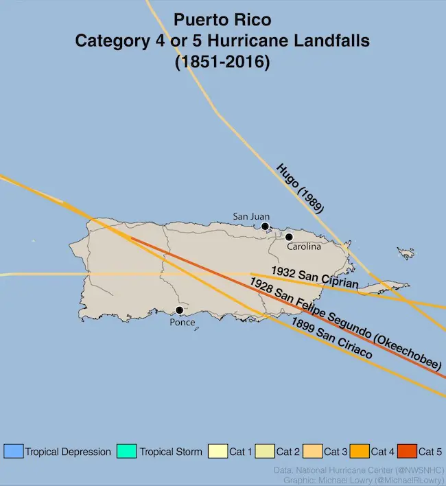
Hurricane History On Puerto Rico
Maria will be the strongest storm to hit Puerto Rico as it is forecast to cross directly over the island. Since 1851, only 4 storms at Category 4 or 5 have hit the island. This plot below is from Michael Lowry.
Maria Will Bring These Deadly Conditions
- Storm Surge: Over 9 Ft
- Winds: 175 mph gusting over 200 mph
- Rainfall: 20+ inches
- The islands are mountainous! This will enhance the rain, flooding, and cause mudslides.
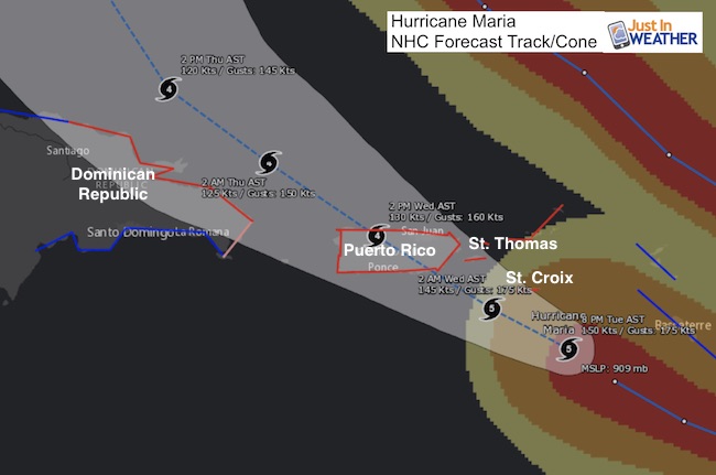
Forecast Path For Maria
Latest Stats
LOCATION…17.3N 64.7W
ABOUT 30 MI…45 KM SSE OF ST. CROIX
ABOUT 120 MI…190 KM SE OF SAN JUAN PUERTO RICO
MAXIMUM SUSTAINED WINDS…175 MPH…280 KM/H
PRESENT MOVEMENT…WNW OR 300 DEGREES AT 10 MPH…17 KM/H
MINIMUM CENTRAL PRESSURE…909 MB…26.85 INCHES
Important Note About Wind Field
35 miles = Hurricane force winds. The 160 mph winds are immediately around the eye wall
140 miles = Tropical Storm Force winds. So 31 miles form the eye wall winds drop to 73 mph or less. But the storm surge does reach much farther than the hurricane force winds. That is the most deadly part of the storm.
Warnings And Watches
A Hurricane Warning is in effect for…
* U.S. Virgin Islands
* British Virgin Islands
* Puerto Rico, Culebra, and Vieques
* Dominican Republic from Cabo Engano to Puerto Plata
A Tropical Storm Warning is in effect for…
* Saba and St. Eustatius
* St. Maarten
* Guadeloupe
* Dominican Republic west of Puerto Plata to the northern border of
the Dominican Republic and Haiti
* Dominican Republic west of Cabo Engano to Punta Palenque
A Hurricane Watch is in effect for…
* Saba and St. Eustatius
* St. Maarten
* St. Martin and St. Barthelemy
* Isla Saona to Cabo Engano
* Turks and Caicos Islands and the Southeastern Bahamas
Puerto Rico Radar
Long Range Forecast
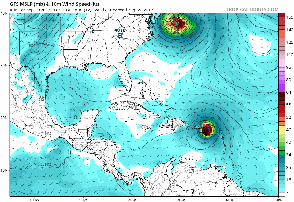
This is the GFS Model generated this afternoon. It is bringing Maria close to the Outer Banks next week, then similar to Jose passing off the coast to our east. The European Model will be germinated overnight with a new update in the morning.
Please share your thoughts, best weather pics/video, or just keep in touch via social media
-
Facebook: Justin Berk, Meteorologist
-
Twitter: @JustinWeather
-
Instagram: justinweather
 Get the award winning Kid Weather App I made with my oldest son and support our love for science, weather, and technology. Our 3 year anniversary of the release and our contribution to STEM education is this November. It has been downloaded in 60 countries, and works in both temperature scales. With your support we can expand on the fun introduction to science and real weather.
Keep on Trekking
Continue to be part of our Maryland Trek and Support Cool Kids Campaign. This was our best event yet and we want the message to carry throughout the year.
Proceeds go to programs that help children and their families ensuring cancer treatment.
