 September 19 2017
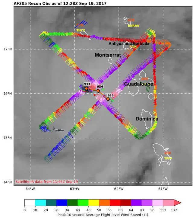
The latest Air Force Reconnaissance mission flying into Hurricane Maria shows the organization and possibly further intensification of this Category 5 storm. After hitting Dominica overnight, the winds were knocked down a little, but recovered back to 160 mph in the latest National Hurricane Center report. The Air Force mission data will be incorporated in the next report and is showing signs of possibly getting stronger.
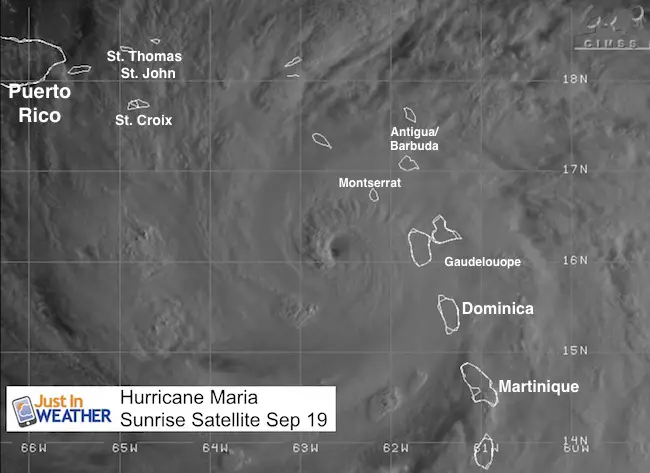
The GOES visible satellite image above shows the storm at sunrise with low angle sun enhancing the shadows of the high clouds around the eye wall. This storm is over very warm water with little to no wind sheer aloft to inhabit growth.
Air Force 305 Mission 4
12:28 Z is 7:28 AM EDT
This shows the path of the flight into the storm crossing the eye wall a few times. The winds are represented by barbs for direction and color for speed. 137 knots at the edge of the legend is equal to 158 mph, the criteria for Category 5
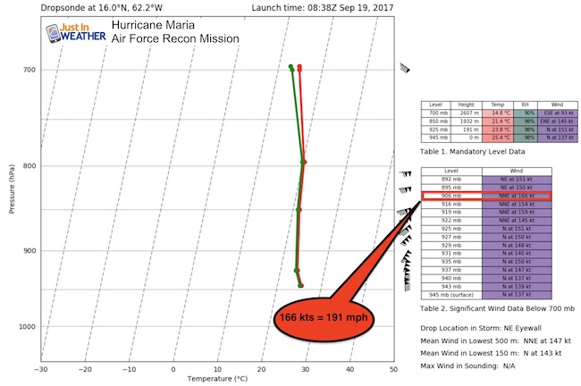
Dropsonde at The Northeast Eye Wall
This is when a package of instruments is dropped from the plane into the storm and the measurements are remotely recorded. This was at the location of the northeast eye wall. That is the strongest part of the storm.
Notice the 905 mb level I highlighted. This shows a wind speed of 166 knots = 191 mph
The mean or average wind speed at 500 meters aloft was 147 knots = 169 mph
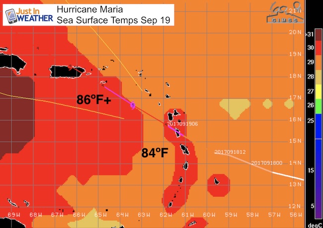
Sea Surface Temperatures
Water temps over 86ºF is pure fuel to energize a tropical cyclone.
Forecast
This is the worst case scenario for The US Virgin Islands and Puerto Rico as the path will have the stronger (right side) of the eye passing over that region. This will be a harder hit on those islands than Irma did for them. They are didn’t see the worst of Irma and yet still have a lot of damage and debris left uncleaned. There is not point to over dramatize this. It will sadly be much worse this time.
Important Note About Wind Field
30 miles = Hurricane force winds. The 160 mph winds are immediately around the eye wall
160 miles = Tropical Storm Force winds. So 31 miles form the eye wall winds drop to 73 mph or less. But the storm surge does reach much farther than the hurricane force winds. That is the most deadly part of the storm.
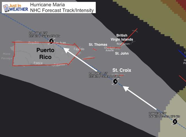
- Storm Surge: 7 to 11 Ft
- Rainfall: 10 to 20 inches (enhanced by mountains)
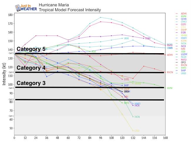
Intensity Forecast
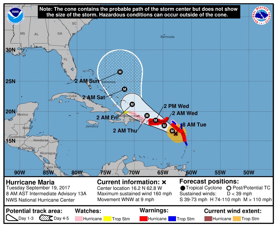
National Hurricane Center Track/Cone
SUMMARY OF WATCHES AND WARNINGS IN EFFECT:
A Hurricane Warning is in effect for…
* Guadeloupe
* Dominica
* St. Kitts, Nevis, and Montserrat
* U.S. Virgin Islands
* British Virgin Islands
* Puerto Rico, Culebra, and Vieques
A Tropical Storm Warning is in effect for…
* Antigua and Barbuda
* Saba and St. Eustatius
* St. Maarten
* Anguilla
* Martinique
A Hurricane Watch is in effect for…
* Saba and St. Eustatius
* St. Maarten
* St. Martin and St. Barthelemy
* Anguilla
* Isla Saona to Puerto Plata
See the full report from this morning here.
The next update from the National Hurricane Center will be at 11 AM EDT
Please share your thoughts, best weather pics/video, or just keep in touch via social media
-
Facebook: Justin Berk, Meteorologist
-
Twitter: @JustinWeather
-
Instagram: justinweather
 Get the award winning Kid Weather App I made with my oldest son and support our love for science, weather, and technology. Our 3 year anniversary of the release and our contribution to STEM education is this November. It has been downloaded in 60 countries, and works in both temperature scales. With your support we can expand on the fun introduction to science and real weather.
Keep on Trekking
Continue to be part of our Maryland Trek and Support Cool Kids Campaign. This was our best event yet and we want the message to carry throughout the year.
Proceeds go to programs that help children and their families ensuring cancer treatment.
