 11 AM Sunday September 10
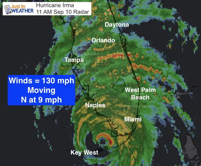
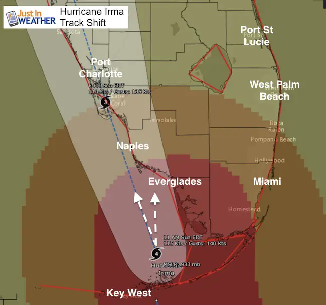
Hurricane Irma remains a strong Category 4 storm with 130 mph winds after moving north of the Cudjoe Key landfall this morning. It is 80 miles from Naples. The motion veered north and that could make it hit land in southwest mainland Florida sooner. It could hit Everglades City and Marco Island, and if so, then be south of Naples. That would change the dynamics of the storm surge until after the eye passes at Naples and would lower the water level threat a little there. At this point a few miles makes a big difference as the eye needs to remain over water to maintain strength. The immediate eye wall has the strongest winds and storm surge as well. This past hour a 120 mph wind gust was measured just east of Key West, 106 mph in Big Pine Key and gusts to 100 mph all the way to Miami. Naples had a gust to 79 mph recently.
Larger Storm
- 80 miles – Hurricane Force Wind Field
- 220 mile – Tropical Storm Force Wind Field
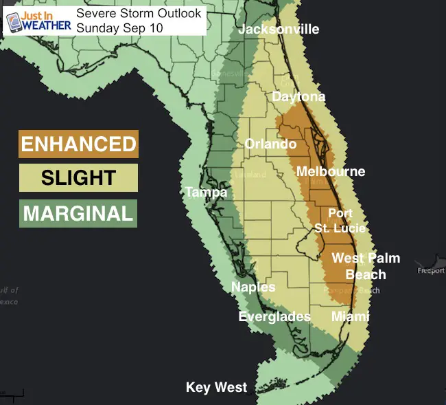
Tornado Risk
The highest chance of tornadoes is on the east coast of Florida as winds off of the Atlantic move faster then slow across land. The resulting wind sheer as the winds aloft remain strong help develop the spin ups and this will remain all day well hundreds of miles away from the eye.
Satellite Loop
7 hours shows the wobbling and reorganizing of the eye as the storm moves away from Cuba and towards Florida
11 AM Stats
LOCATION…25.0N 81.5W
ABOUT 80 MI…125 KM SSE OF NAPLES FLORIDA
ABOUT 115 MI…180 KM SSE OF FT. MYERS FLORIDA
MAXIMUM SUSTAINED WINDS…130 MPH…215 KM/H
PRESENT MOVEMENT…N OR 350 DEGREES AT 9 MPH...15 KM/H
MINIMUM CENTRAL PRESSURE…933 MB…27.55 INCHES
Hurricane Warning And Track
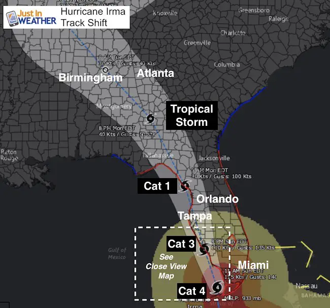
Notice the shift to the north on the right side of the former forecast cone. A wobble and adjustment is common for a hurricane near land. If this does make landfall sooner, it would weaken sooner, and might take down some of the storm surge farther up the coast… but the damage threat will remain for most of Florida and move north all day.
Landfall could be anywhere from Port Charlotte to Sanibel or Naples, Marco Island or Everglades as seen at this time. Too close to call but leaning on the last two listed here.
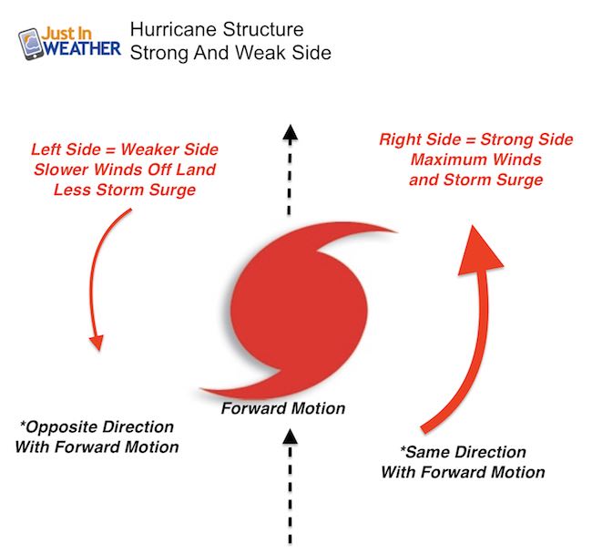
Remember this storm has a wave memory or momentum of a prior 185 mph wind storm. The storm surge will be the top of the potential. The east/right side of the eye will have the worst impact!
See the list of warnings and watches below
Reminder: Storm Structure
Track Farther North- Just off the west coast
Based off of the earlier track. Need to adjust the long range track to the right
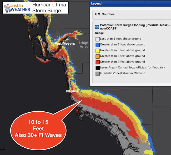
Storm Surge Max to 10 15 Ft
Add in 30+ Ft waves on top and the water level along the coast could reach 45 Ft above normal. That would cover, damage, and likely wipe out structures 3 to 4 stories tall!
Yes, the water level can drop a lot on outer edge of the storm was the water gets sloshed around the eye depending on wind direction. Low water in Naples will be replaced quickly by strong return as eye passes overhead or to their east (inland).
A Storm Surge Warning is in effect for…
* South Santee River southward to Jupiter Inlet
* North Miami Beach southward around the Florida peninsula to the
Ochlockonee River
* Florida Keys
* Tampa Bay
Surge Forecast
Cape Sable to Captiva…10 to 15 ft
Captiva to Ana Maria Island…6 to 10 ft
Card Sound Bridge through Cape Sable, including the Florida Keys…
5 to 10 ft
Ana Maria Island to Clearwater Beach, including Tampa Bay…
5 to 8 ft
North Miami Beach to Card Sound Bridge, including Biscayne Bay…
3 to 5 ft
South Santee River to Fernandina Beach…4 to 6 ft
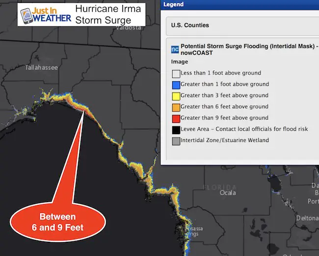
Clearwater Beach to Ochlockonee River…4 to 6 ft
Fernandina Beach to Jupiter Inlet…2 to 4 ft
North of North Miami Beach to Jupiter Inlet…1 to 2 ft
Worst Impact Area
Farther North Up The Coast
Warnings and Watches
Almost the entire state is under the risk of Hurricane Force Winds and Tornados. Tropical Storm Watch through Atlanta, GA for Monday!
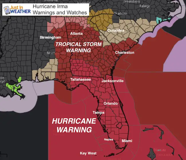
SUMMARY OF WATCHES AND WARNINGS IN EFFECT:
A Hurricane Warning is in effect for…
* Fernandina Beach southward around the Florida peninsula to Indian
Pass
* Florida Keys
* Lake Okeechobee
* Florida Bay
* Cuban provinces of Matanzas and La Habana
A Hurricane Watch is in effect for…
* North of Fernandina Beach to Edisto Beach
A Tropical Storm Warning is in effect for…
* West of Indian Pass to the Okaloosa/Walton County Line
* North of Fernandina Beach to South Santee River
A Tropical Storm Watch is in effect for…
* Bimini and Grand Bahama
Arrival time of Tropical Storm Force Winds
Keep on Trekking
Continue to be part of our Maryland Trek and Support Cool Kids Campaign. This was our best event yet and we want the message to carry throughout the year.
Proceeds go to programs that help children and their families ensuring cancer treatment.

Please share your thoughts, best weather pics/video, or just keep in touch via social media
-
Facebook: Justin Berk, Meteorologist
-
Twitter: @JustinWeather
-
Instagram: justinweather
 Get the award winning Kid Weather App I made with my oldest son and support our love for science, weather, and technology. Our 3 year anniversary of the release and our contribution to STEM education is this November. It has been downloaded in 60 countries, and works in both temperature scales. With your support we can expand on the fun introduction to science and real weather.