 8 AM Sunday September 10
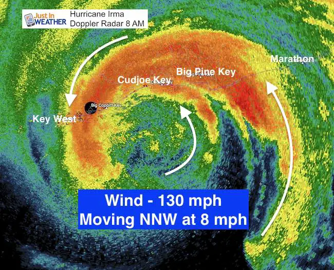
I do not want to enhance the hype but this is as bad as it gets! Hurricane Irma did strengthen early this morning back to a Category 4 storm. The eye wall is 20 miles to the southeast of Key West, which may help them a little. Their last wind was 94 mph. The direct hit and passage of the eye will be between Big Coppott, Cudjoe, and Big Pine Key. Marathon Key is on the stronger east side. I’ve annotated the wind direction to show the flow better. All areas here will be in the steady 100 mph wind zone this hour and for the next few hours. The winds are 130 mph gusting to 160 mph around the eye way. The size of the impact zone has grown larger. Miami has winds gusted to 68 mph already. Numerous tornados have been reported as far away as West Palm Beach and Jupiter on the east coast. That will expand north through Florida all day.
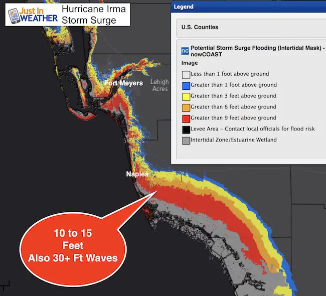
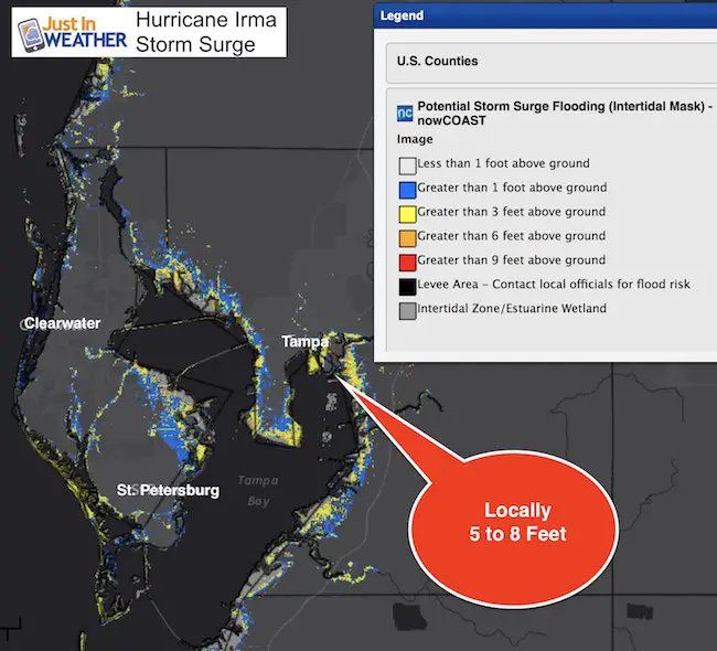
Storm surge will be up to 15 feet with waves 30 + Feet high. That will completely cover buildings 2 to 3 floors tall with the worst expected near Naples. A max hit around Tampa as well later. Sadly many who stayed are in danger of death or being trapped or stuck for a long time. Surge maps below.
Note: The dark black circle by Key West is the actual radar location can blocked out since it can’t see in a short radius.
Larger Storm
- 80 miles – Hurricane Force Wind Field
- 220 mile – Tropical Storm Force Wind Field
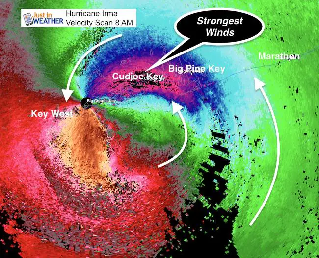
This Velocity Scan shows the strongest winds in the black shading. Doppler is showing faster winds than hunter aircraft (so I won’t mention them here) which may be a function of the error at such intense conditions.
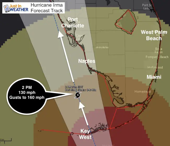
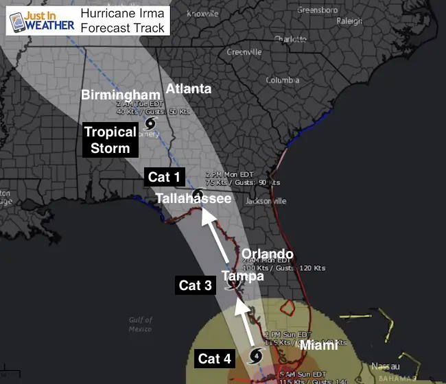
The slow forward movement and up tick in intensity will lead to maximum impact on southwest Florida. The slower speed has also allowed it to make a smoother turn and the trend keeps is just west of the Florida mainland. The edge of the eye may remain just offshore of the west coast all day. If the core remains over water, it will allow Irma to maintain intensity longer. There is no way to sugar coat this… This is the worst case scenario for all of west Florida and many who remained will be killed or stuck for a long time. I have friends who are in the path, so please understand that it hurts me to mention that.
Note: Tina Fling informed me that her son is one of those meteorologists bunkered in the Key West NWS Office. She will share any direct updates from him during the day.
Satellite Loop
7 hours shows the wobbling and reorganizing of the eye as the storm moves away from Cuba and towards Florida
8 AM Stats
LOCATION…24.5N 81.5W
ABOUT 20 MI…30 KM ESE OF KEY WEST FLORIDA
ABOUT 110 MI…180 KM S OF NAPLES FLORIDA
MAXIMUM SUSTAINED WINDS…130 MPH…215 KM/H
PRESENT MOVEMENT…NNW OR 330 DEGREES AT 8 MPH…13 KM/H
MINIMUM CENTRAL PRESSURE…929 MB…27.43 INCHES
Hurricane Warning And Track
Notice the shift to the west of the coast. This may allow the intensity to hold strength while the strongest part of the eye wall hits land. This could be the worst set up for the Keys to Naples. The forecast updated to show remaining a Cat 4 longer due to the eye remaining over water.
Remember this storm has a wave memory or momentum of a prior 185 mph wind storm. The storm surge will be the top of the potential. The east/right side of the eye will have the worst impact!
See the list of warnings and watches below
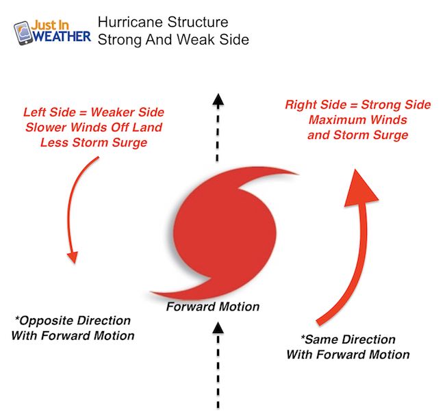
Reminder: Storm Structure
Track Farther North- Just off the west coast
Storm Surge Max to 10 15 Ft
Add in 30+ Ft waves on top and the water level along the coast could reach 45 Ft above normal. That would cover, damage, and likely wipe out structures 3 to 4 stories tall!
A Storm Surge Warning is in effect for…
* South Santee River southward to Jupiter Inlet
* North Miami Beach southward around the Florida peninsula to the
Ochlockonee River
* Florida Keys
* Tampa Bay
Surge Forecast
Cape Sable to Captiva…10 to 15 ft
Captiva to Ana Maria Island…6 to 10 ft
Card Sound Bridge through Cape Sable, including the Florida Keys…
5 to 10 ft
Ana Maria Island to Clearwater Beach, including Tampa Bay…
5 to 8 ft
North Miami Beach to Card Sound Bridge, including Biscayne Bay…
3 to 5 ft
South Santee River to Fernandina Beach…4 to 6 ft
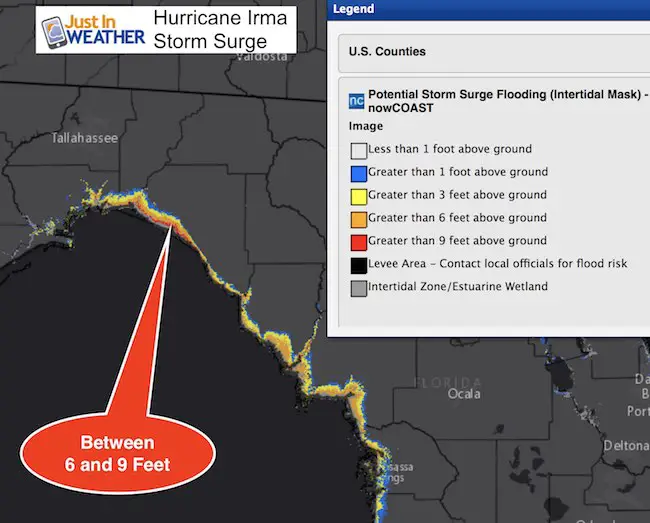
Clearwater Beach to Ochlockonee River…4 to 6 ft
Fernandina Beach to Jupiter Inlet…2 to 4 ft
North of North Miami Beach to Jupiter Inlet…1 to 2 ft
Worst Impact Area
Farther North Up The Coast
Warnings and Watches
Almost the entire state is under the risk of Hurricane Force Winds and Tornados. Tropical Storm Watch through Atlanta, GA for Monday!
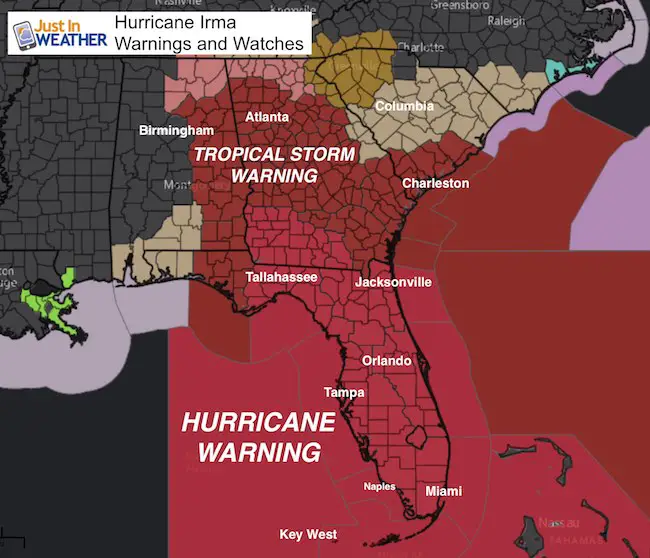
SUMMARY OF WATCHES AND WARNINGS IN EFFECT:
A Hurricane Warning is in effect for…
* Fernandina Beach southward around the Florida peninsula to Indian
Pass
* Florida Keys
* Lake Okeechobee
* Florida Bay
* Cuban provinces of Matanzas and La Habana
A Hurricane Watch is in effect for…
* North of Fernandina Beach to Edisto Beach
A Tropical Storm Warning is in effect for…
* West of Indian Pass to the Okaloosa/Walton County Line
* North of Fernandina Beach to South Santee River
A Tropical Storm Watch is in effect for…
* Bimini and Grand Bahama
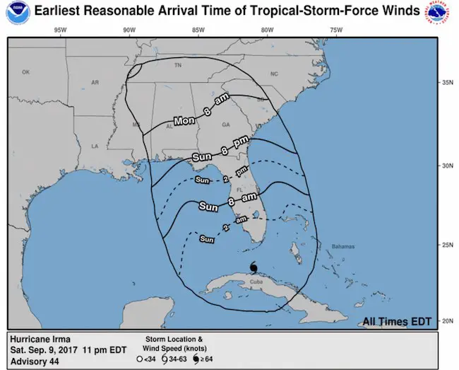
Arrival time of Tropical Storm Force Winds
Keep on Trekking
Continue to be part of our Maryland Trek and Support Cool Kids Campaign. This was our best event yet and we want the message to carry throughout the year.
Proceeds go to programs that help children and their families ensuring cancer treatment.

Please share your thoughts, best weather pics/video, or just keep in touch via social media
-
Facebook: Justin Berk, Meteorologist
-
Twitter: @JustinWeather
-
Instagram: justinweather
 Get the award winning Kid Weather App I made with my oldest son and support our love for science, weather, and technology. Our 3 year anniversary of the release and our contribution to STEM education is this November. It has been downloaded in 60 countries, and works in both temperature scales. With your support we can expand on the fun introduction to science and real weather.