Wednesday September 6
Today Hurricane Irma set a record in the Atlantic basin maintaining winds of 185 mph for 24 hours. It beat Hurricane Allen from 1980 that was stronger at 190 mph, but held the speed over 180 mph for 18 hours that year. While at this speed, the eye passed within 50 miles north of San Juan, Puerto Rico. At this time, the hurricane force winds reached 50 miles form the center and the tropical storm force winds reached 185 miles away. The island was being battered.
Here we can see a 4 hour loop of Doppler Radar out of San Juan, PR. It was 4:36 PM to 8:46 PM AST. Below you can compare this to the satellite loop of various spectrums.
Infrared Satellite of various spectrums
Note, the first view is the infrared satellite (from space) with National Hurricane Center coloring of cloud tops. This enhancement shows height and intensity of convection. It may look like radar, but it is not showing rainfall intensity. Just the colder/higher cloud tops.
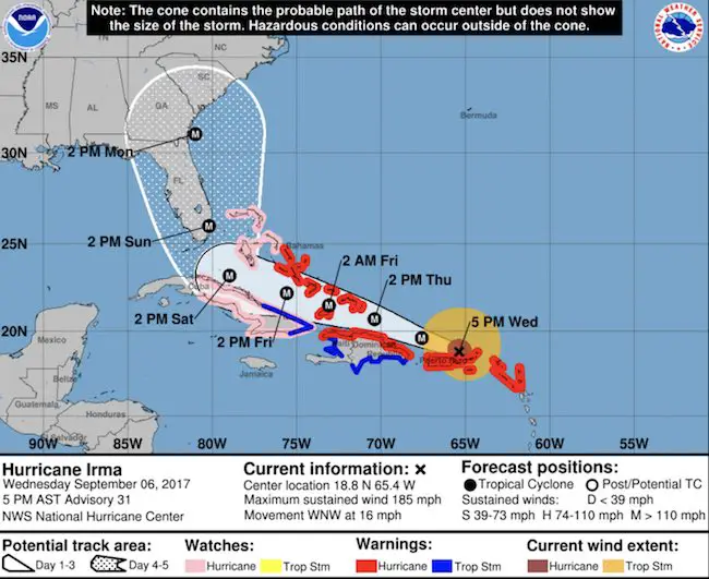
For more on Irma and the latest track towards the mainland US, see my prior report here
Click the image to see the latest on Irma’s Path (Wednesday Afternoon Sep 6)
Keep on Trekking
Continue to be part of our Maryland Trek and Support Cool Kids Campaign. This was our best event yet and we want the message to carry throughout the year.
Proceeds go to programs that help children and their families ensuring cancer treatment.

Please share your thoughts, best weather pics/video, or just keep in touch via social media
-
Facebook: Justin Berk, Meteorologist
-
Twitter: @JustinWeather
-
Instagram: justinweather
 Get the award winning Kid Weather App I made with my oldest son and support our love for science, weather, and technology. Our 3 year anniversary of the release and our contribution to STEM education is this November. It has been downloaded in 60 countries, and works in both temperature scales. With your support we can expand on the fun introduction to science and real weather.