Wednesday August 2
Severe storms have erupted early this afternoon as suggested this morning. If you followed my posts online I showed the castleling clouds and then the early pop up showers in southern York County that included hail. More daily heating has helped enhance the atmosphere and the subtle boundaries are hinting at where more storms may form and the focus dropping south into central Maryland later this afternoon.
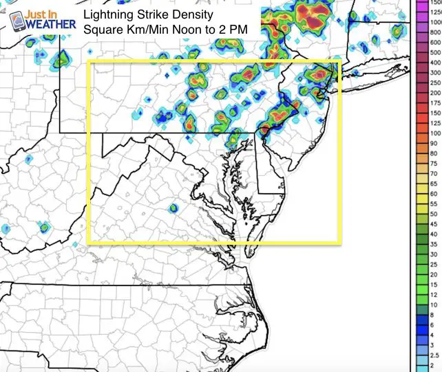
Lighting Density
This product shows the 2 hour summary ending at 2 PM of lightning. Under these storms its has been intense cloud to ground and frequent. They make loud boomers and can be dangerous.
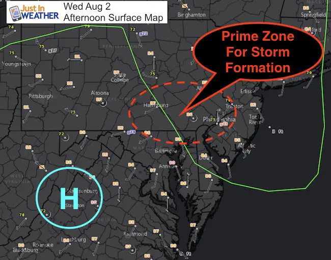
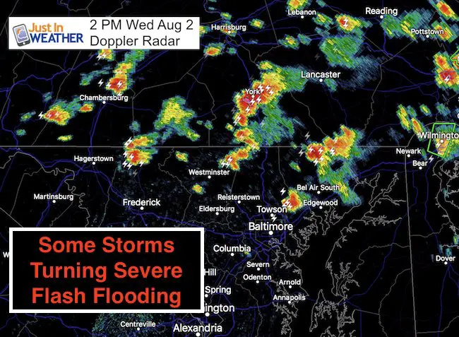
Surface Map and Doppler at 2 PM
There is a weak area of High Pressure in Virginia and the trough in eastern Pennsylvania acting on the high humidity. This red circle is the same region I showed this morning and where the storms ignited so far today. Compare to the Doppler Radar from 2 PM below…
Why can we expect:
I see the energy focus shifting southward to metro Baltimore. Perhaps again acting on a Bay Breeze Boundary around I-95 to give rise to new storms mid afternoon.
- Severe Storms With Large Hail: Any storm may produce quarter size hail
- Frequent lightning
- Winds exceeding 60 mph
- Flash Flooding
Radar Simulation —-> slider
[metaslider id=50455]
Weather Alert Notes
Watch means in might happen in a given region. Time frame is over a few hours.
Warning means it is happening now and being tracked through specific towns during a 30 to 60 minute span.
Please check back later for more and be safe
Please share your thoughts, best weather pics/video, or just keep in touch via social media
-
Facebook: Justin Berk, Meteorologist
-
Twitter: @JustinWeather
-
Instagram: justinweather
 Get the award winning Kid Weather App I made with my oldest son and support our love for science, weather, and technology. Our 3 year anniversary of the release and our contribution to STEM education is this November. It has been downloaded in 60 countries, and works in both temperature scales. With your support we can expand on the fun introduction to science and real weather.
Maryland Trek 2017
Donations now being accepted. Please select “Cool Kids Campaign” in the options to add to our entire team’s total.
Milestones this year:
- I will do my 1000th mile on Day 1 in Garrett County
- We aim to reach $100,000 for Cool Kids Campaign for the entire event.

Kent Island Tornado
Doppler Radar Loop: Likely Tornado On Kent Island July 24
Tornado Damage Photos On Kent Island: July 24 2017
Waterspout Video and Photos July 15 2017
Waterspouts photos August 21 2016
Faith in the Flakes
The store is closing for the season. Next week we wil be shifting back to spring mode. This will include a severe weather STEM assembly program.
-
Sign up for email updates on new posts
Since you may miss some posts via social media, click here for email alerts as a way to make sure you don’t miss any. *You may have to refresh that page once for your browser to clear out the images.
Also See: