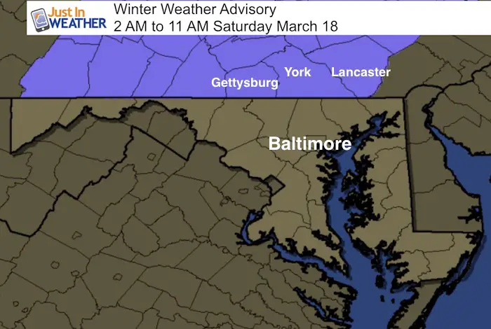
 March 17 – The luck of the Irish may be helping the Maryland thaw but not Pennsylvania. A warm front ahead of a Mid Wester Low Pressure will arrive this evening. There may be some sleet and snow mixed in with some rain this evening, but warming should take over. But near and especially north of the boarder in PA, colder temps will allow for some icing to develop. The Winter Weather Advisory includes Adams, York, and Lancaster Counties and northbound. Deeper snow pack and colder air, plus the rugged hills and valleys will help the cold hold longer.
Some roads and sidewalks could get icy overnight and into Saturday morning. While the Advisory lasts until 11 AM, I think most areas should be fine just after sunrise. It will be a quiet day, then were watch the second part of this system drag down colder air Saturday night. This is when snow will return and extend southward into Maryland. If you have plans late Saturday night or Church plans early Sunday, this could play a role in your travels. See the Maos below.
—-> slider Wintry Mix Tonight
[metaslider id=45595]
—> slider Snow Returns Sunday Morning
A secondary Low will form with this pattern. It will drag in colder air and bring in snow Saturday night into Sunday. Notice the last few maps and where the freezing line is. I expect there will be some accumulation and some road problems… but it would be hard to get more than 1 inch out of this. At this point, the snow may may be briefly moderate in Harfrod, Cecil and Kent Counties in Maryland… and northern Delaware to Philadelphia. Just consider a slight delay for your plans.
[metaslider id=45596]
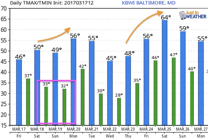
Temperature Outlook
Sprig Officially begins Monday morning. Temperatures will be warming up next week

 Get the award winning Kid Weather App I made with my oldest son and support our love for science, weather, and technology. Our 3 year anniversary of the release and our contribution to STEM education is this November. It has been downloaded in 60 countries, and works in both temperature scales. With your support we can expand on the fun introduction to science and real weather.
Please share your thoughts, best weather pics/video, or just keep in touch via social media
-
Facebook: Justin Berk, Meteorologist
-
Twitter: @JustinWeather
-
Instagram: justinweather
Faith in the Flakes
The store is closing for the season. Next week we wil be shifting back to spring mode. This will include a severe weather STEM assembly program.
-
Sign up for email updates on new posts
Since you may miss some posts via social media, click here for email alerts as a way to make sure you don’t miss any. *You may have to refresh that page once for your browser to clear out the images.
Also See:
My Winter Outlook for 2016-2017: Colder with snow spread out more
NOAA Winter Outlook for 2016 to 2017
La Nina Formed: What it could mean to our winter
Farmers Almanacs Split On Cold And Snow
Extreme Weather of 2015 balanced out on both ends
Low Snow Winters In Baltimore: Records Might Surprise You
