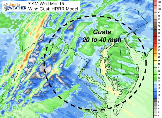
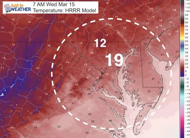
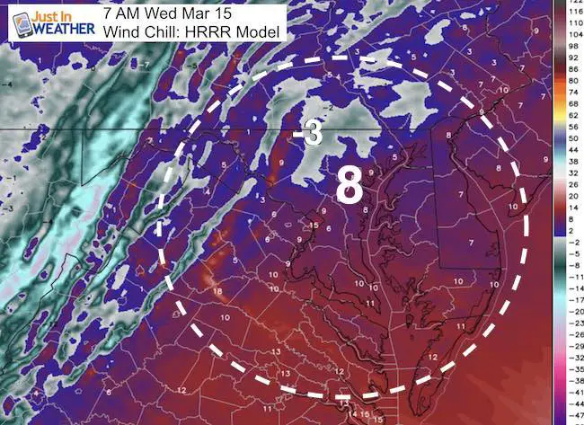
 March 15 – The storm is located in northern New England and is the gift that keeps on giving. We have set up a winter pattern to make up for lost time as strong winds and bitterly cold air is in place. The focus this morning should be the wind chills. By noon, one more piece of energy will produce a band of snow. That could be enough to coat the roads in a heavier squall. But while the visibly may drop low and appear like a storm is raging, it shouldn’t last more than an hour or so at the most.
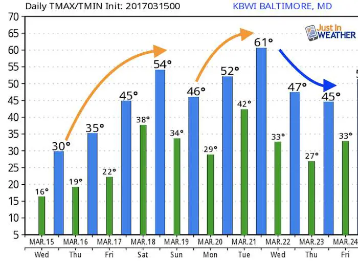
The day itself will remain cold, but March sun angle will help to thaw any iced over pavement. It’s any coating off snow or puddles this afternoon that will refreeze again tonight. So another round of salting will be on order. Then we gradually warm up ahead of the next system that should bring rain Friday night and Saturday.If it helps, spring begins next Monday March 20
This Morning
Strong Winds and Restrictions On Bridges
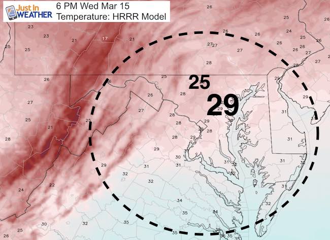
Cold Temps But Colder Wind Chill
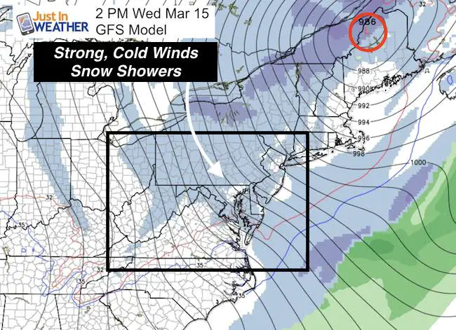
—> slider Snow Showers
*Snow squalls could briefly drop visibility and bring a coating to a quick inch
[metaslider id=45496]
#FITF Gear
We are doing a special run of more Faith in the Flakes shirts this week. Click here for the online store to get yours.
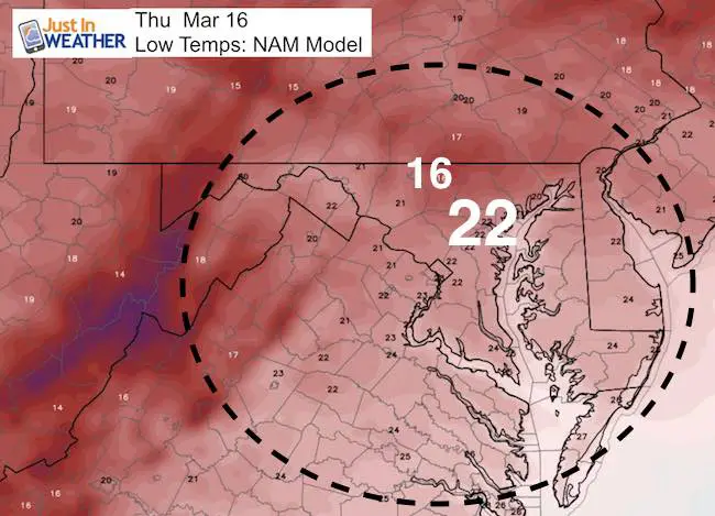
Re-Freeze: Evening and Overnight Low Temperatures
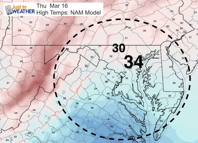
Slight Thaw Tomorrow
Outlook
Next Storm Should Bring Rain Friday Night-Saturday
—> slider
[metaslider id=45514]
Temperatures
 Get the award winning Kid Weather App I made with my oldest son and support our love for science, weather, and technology. Our 3 year anniversary of the release and our contribution to STEM education is this November. It has been downloaded in 60 countries, and works in both temperature scales. With your support we can expand on the fun introduction to science and real weather.
Please share your thoughts, best weather pics/video, or just keep in touch via social media
-
Facebook: Justin Berk, Meteorologist
-
Twitter: @JustinWeather
-
Instagram: justinweather
Faith in the Flakes Online- Flannel PJs Printed Inside Out
Store Now Open

- We’ve added Flannel PJ Pants that will be printed inside out. They have to be, to make it snow ?
- Free Personal Delivery for orders of 20 items or more to schools and businesses.
- Click this image for the online store.
- Look for more items to be added soon.
- Also see the info for the STEM Assembly Spirit Wear program: Put your school name on the shirts and raise money for you PTO/PTA in the process.
Sign up for email updates on new posts
Since you may miss some posts via social media, click here for email alerts as a way to make sure you don’t miss any. *You may have to refresh that page once for your browser to clear out the images.
FITF SNOW STICKS
 Available in 2 Ft, 30 Inches, and 3 Ft Sizes. Also with Orange/Black or Purple/Black. Click on the image to see the options offered by my friend Thatcher at Signs By Tomorrow in Timonium.
Go to http://www.signsbytomorrow.com/timonium/ to order yours today! Click the ‘Request a Quote’ button at the top of the page. In comment box include color, size and payment information. Please indicate whether you’d like to have us UPS ship them to you or if you would like to pick up in our store. Snow Sticks will ship or will be ready for pick up in our store 48 hrs after order is placed, Mon-Fri.
Also See:
My Winter Outlook for 2016-2017: Colder with snow spread out more
NOAA Winter Outlook for 2016 to 2017
La Nina Formed: What it could mean to our winter
Farmers Almanacs Split On Cold And Snow
Extreme Weather of 2015 balanced out on both ends
Low Snow Winters In Baltimore: Records Might Surprise You