Friday March 10 – The snow event this morning seems to have behaved as expected. That being the timing, duration, and the extent of snow. Basically, the track pushed the snow where it was suppose to go and that was a critical part of what I look for to see how the models are handling our new pattern… A real winter pattern dominated by the northern branch of the jet stream. We still need to get snow reports and compare to my map, but now I have more confidence looking forward. This includes the hard freeze this weekend and coastal storm next week. Yes, that is still ‘on’. So if you thought today was a tease, we have more on the way. At this point, anything would be more, right? But please read carefully as I have points I want to make.
I want to thank Mother Seton School for hosting a great assembly this morning, and I have a meeting this afternoon about my spring severe storm assembly program. So this will be brief… I will elaborate more later
Weekend Freeze
The snow may have melted but a hard freeze is moving in tonight. Lows Saturday morning will be in the mid teens to low 20s. This may be an early crop and blossom killer. It will also take a lot of heat out of the ground.
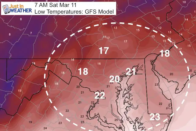
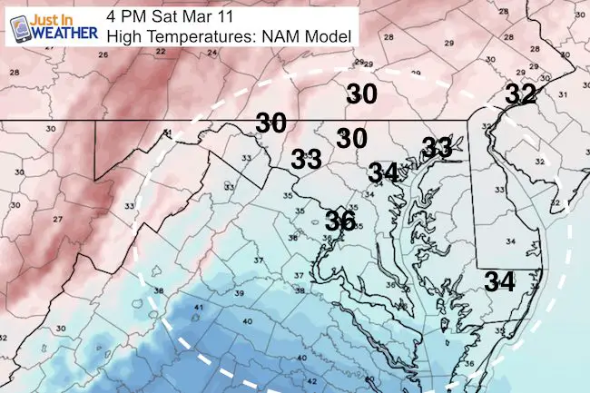
Saturday Afternoon will stay below freezing inland, but make it back to the mid 30s for some, but feel colder…. only to set up another hard freeze Sunday morning. Keep these numbers in mind. the Chesapeake Bay water is mild and could also play an warming effect on the next storm.
Race Weather:
If you are running in the Shamrock 5K in Baltimore or going to the parade on Sunday… Maybe I’ll see you. I will be bundled up though. Temps will stay in the 30s and I expect more will bag the race for a jog rather than PR. Cold stays longer and cools down the ground.
Coastal Storm- FITF:
As of now, I have more trust that the storm will form and bring the best chance of snow all winter. This will be a system that doesn’t exist yet and will be the result of some phasing of the northern and southern branches of the jet stream. This is the best chance to show off your FITF gear again with reason.
Timing:
Monday Night to Tuesday Night, maybe snow showers into Wednesday.
Stickage:
Getting the snow to lay and stay will be easier not week after the weekend freeze and cold afternoons. The ground will be much colder and the arrival of snow overnight will help set up the base layer for the flakes friends to join in.
Model Maps
The GFS is showing something I don’t like as a snow lover, but I am glad to point out now. Notice the heavy snow show a mix near the Bay. wind direction as well as storm location will determine any warm air mixing in and change from snow to ‘other stuff’. This is a stronger system, and the European Model is even strong. But, the Canadian Model deserves it’s mention. This model was the first to show the Sunday storm this weekend miss us and develop the Tuesday storm. This model is best in cold patterns. While I respect it in winter… this is showing a coastal singular event that may not be as large and pull away sooner. I need to show this for contrast and refer to for future posts to see which has a better handle.
GFS Model —> slider
May introduce a mix around I-95/Bay Tuesday morning? This shows phasing of two systems, which will be the stronger solution and linger the snow longer…
Canadian GEM Model —> slider
Colder, but set up for single storm off of the coast… that could slide off shore sooner.
[metaslider id=44205]How Much Snow
I DO NOT believe in showing any model snowcaps now, let along giving amounts. As some of you may have noticed, some models have already scaled back. There are too many variables and once a large number is given, the public perception is to lock on that. It can’t be taken back without looking like the whole thing is wrong. So… Please wait for my first call by Saturday night or Sunday morning.
 Get the award winning Kid Weather App I made with my oldest son and support our love for science, weather, and technology. Our 3 year anniversary of the release and our contribution to STEM education is this November. It has been downloaded in 60 countries, and works in both temperature scales. With your support we can expand on the fun introduction to science and real weather.
Please share your thoughts, best weather pics/video, or just keep in touch via social media
-
Facebook: Justin Berk, Meteorologist
-
Twitter: @JustinWeather
-
Instagram: justinweather
Faith in the Flakes Online- Flannel PJs Printed Inside Out
Store Now Open

- We’ve added Flannel PJ Pants that will be printed inside out. They have to be, to make it snow ?
- Free Personal Delivery for orders of 20 items or more to schools and businesses.
- Click this image for the online store.
- Look for more items to be added soon.
- Also see the info for the STEM Assembly Spirit Wear program: Put your school name on the shirts and raise money for you PTO/PTA in the process.
Sign up for email updates on new posts
Since you may miss some posts via social media, click here for email alerts as a way to make sure you don’t miss any. *You may have to refresh that page once for your browser to clear out the images.
FITF SNOW STICKS
 Available in 2 Ft, 30 Inches, and 3 Ft Sizes. Also with Orange/Black or Purple/Black. Click on the image to see the options offered by my friend Thatcher at Signs By Tomorrow in Timonium.
Go to http://www.signsbytomorrow.com/timonium/ to order yours today! Click the ‘Request a Quote’ button at the top of the page. In comment box include color, size and payment information. Please indicate whether you’d like to have us UPS ship them to you or if you would like to pick up in our store. Snow Sticks will ship or will be ready for pick up in our store 48 hrs after order is placed, Mon-Fri.
Also See:
My Winter Outlook for 2016-2017: Colder with snow spread out more
NOAA Winter Outlook for 2016 to 2017
La Nina Formed: What it could mean to our winter
Farmers Almanacs Split On Cold And Snow
Extreme Weather of 2015 balanced out on both ends
Low Snow Winters In Baltimore: Records Might Surprise You
Faith in the Flowers
In a few weeks my friend Lexi Hack and I will be bringing back these shirts and the fundraiser for Save a Limb Fund at Sinai Hospital. Also stay tuned for my new Storm Smart Assembly program. A STEM based assembly on severe weather for elementary and middle schools.