Friday March 10 – The snow this morning was already showing up in Pennsylvania at 5 AM while light rain is developing in central Maryland. Temperatures were still rather mild (mid 40s) ahead of the front and the lag of colder air will mean that heavy snow will fall from colder clouds, but fall on warm ground and with temps just above freezing for a while. The makes it difficult to determine where the stickage will be. It’s one thing to get it on the grass and measure it, but the roads are really the concern. Heavy snow can cover roads with slush even when the air is still above freezing… if it is heavy enough. Also, visibility will be lowered with big flakes.

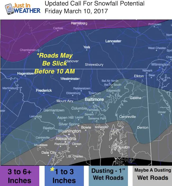
“If it doesn’t snow by you, it doesn’t mean it didn’t happen” – You can quote me on that. There may be three to 4 four of snow from Westminster to York PA this morning, while Towson may only have an hour or two. Meanwhile Baltimore and south may only get a brief band of snow around lunchtime.
Here’s the timeline to transition… it looks rain this morning will change over in a few hours. The snow line will stay north of Annapolis and the heaviest may be between 9 and 11 AM. At that point, traffic is lower and the higher sun angle should help limit stiackge on the roads. The freezing line will stay up in northern Maryland and southern PA where there may be a brief period of snow snow covered roads. Below is a look at the Tuesday Coastal storm.
Snow Timeline
Radar Simulation —> slider HRRR Model
York get snow between 7 and 8 AM. Westminster by 9 AM. But Towson and north Baltimore might not see the change until 11 AM
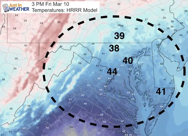
Temperatures
Still above freezing and snow on the north end near PA line.
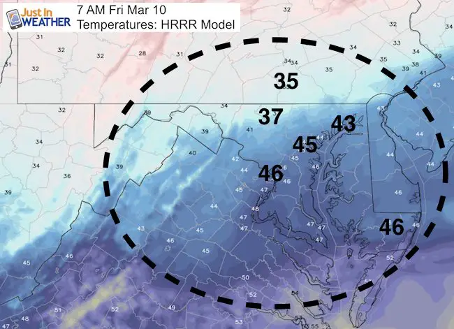
Coldest period of the morning….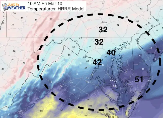
Windy, but above freezing. Temps will crash after dark.
My Final Call For Snowfall
- Note- mostly on the grass.
- Most roads will be wet.
- Most likely travel issues will be 7 to 10 AM north/west of Baltimore.
- Snow showers afternoon and evening
Weekend:
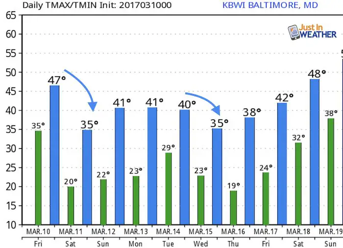
Note the Sunday Storm will stay south… But we will have a bitter hard freeze that will kill early sports and blossoms. Lows down near 20ºF Saturday through Monday morning.
Coastal Storm Tuesday
—> slider GFS Model
This is important to keep in mind: The track is still not a lock. A shift of even 50 miles can make or break the rain snow line that is very close to Washington and Baltimore. So no promises yet and I think posting snow maps for this event now is irresponsible and misleading.
[metaslider id=44180]
Temperature Outlook
 Get the award winning Kid Weather App I made with my oldest son and support our love for science, weather, and technology. Our 3 year anniversary of the release and our contribution to STEM education is this November. It has been downloaded in 60 countries, and works in both temperature scales. With your support we can expand on the fun introduction to science and real weather.
Please share your thoughts, best weather pics/video, or just keep in touch via social media
-
Facebook: Justin Berk, Meteorologist
-
Twitter: @JustinWeather
-
Instagram: justinweather
Faith in the Flakes Online- Flannel PJs Printed Inside Out
Store Now Open

- We’ve added Flannel PJ Pants that will be printed inside out. They have to be, to make it snow ?
- Free Personal Delivery for orders of 20 items or more to schools and businesses.
- Click this image for the online store.
- Look for more items to be added soon.
- Also see the info for the STEM Assembly Spirit Wear program: Put your school name on the shirts and raise money for you PTO/PTA in the process.
Sign up for email updates on new posts
Since you may miss some posts via social media, click here for email alerts as a way to make sure you don’t miss any. *You may have to refresh that page once for your browser to clear out the images.
FITF SNOW STICKS
 Available in 2 Ft, 30 Inches, and 3 Ft Sizes. Also with Orange/Black or Purple/Black. Click on the image to see the options offered by my friend Thatcher at Signs By Tomorrow in Timonium.
Go to http://www.signsbytomorrow.com/timonium/ to order yours today! Click the ‘Request a Quote’ button at the top of the page. In comment box include color, size and payment information. Please indicate whether you’d like to have us UPS ship them to you or if you would like to pick up in our store. Snow Sticks will ship or will be ready for pick up in our store 48 hrs after order is placed, Mon-Fri.
Also See:
My Winter Outlook for 2016-2017: Colder with snow spread out more
NOAA Winter Outlook for 2016 to 2017
La Nina Formed: What it could mean to our winter
Farmers Almanacs Split On Cold And Snow
Extreme Weather of 2015 balanced out on both ends
Low Snow Winters In Baltimore: Records Might Surprise You
Faith in the Flowers
In a few weeks my friend Lexi Hack and I will be bringing back these shirts and the fundraiser for Save a Limb Fund at Sinai Hospital. Also stay tuned for my new Storm Smart Assembly program. A STEM based assembly on severe weather for elementary and middle schools.