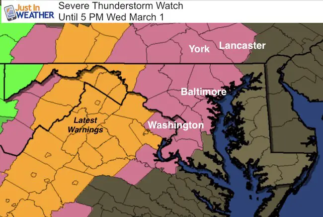
 1:05 PM Wednesday March 1 – We are under a Severe Thunderstorm Watch Until 5 PM. This means that storms will have the potential to reach limits that can produce winds over 58 mph, large hail over 1 inch in diameter, and an isolated tornado. The time frame is likely to be shaved off and cancelled since the quick moving line of storms passes through, For central Maryland and southern PA. that will be between 2 3 PM, then 4PM on the Eastern shore. Basically, shortly after I complete this post.
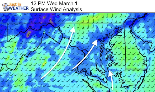
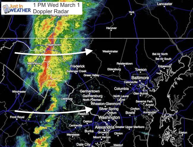
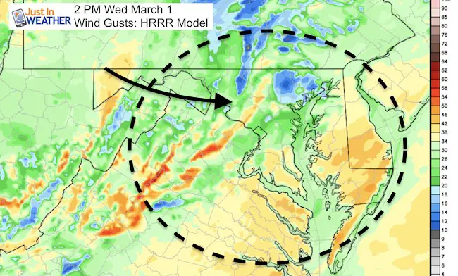
Below I am posting the latest radar to compare to the HRRR Model radar simulation slider. It is NIOT perfect, but a guide…and we can see expect a slight buffer to the time frame. Also, I’ve included a few other parameters. The wind direction is key to severe weather potential between the mountains and I-95 in Maryland. As I pointed out this past weekend and many times before, a southeast wind will maximize the storm potential, feeding winds in off of the Bay. Usually a SW wind flow like we have had today, will allow the storms to weaken a little along I-70, but remain strong near and north of the PA line. However, there is a hint of the southeast flow at the southern Chesapeake Bay. Should this draw farther north, it might help the activity between Kent Island and Baltimore.
See more about the Enhanced Risk of Storms today
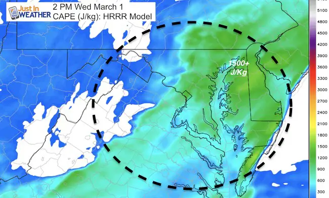
CAPE: Convective Available Potential Energy
There are some other elements that the short range models show could lead to peak activity along Carroll, Baltimore Counties and the northern Eastern Shore. The range of 1500 J/Kg or higher appears to pulse, but peak in Kent and Queens Annes County MD ahead of the storm. So if we can track a strong cell from Carroll to Baltimore as the simulation shows below, this may impact the Delmarva as well.
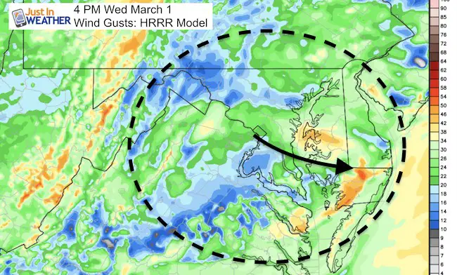
Winds will remain strong behind the line and might be an issue on the bridges for the commute home.
Radar SnapShot as of Post Time
Compare to the first image of the simulation below and see the projection is close, but allow for a 15 to 30 minute buffer.
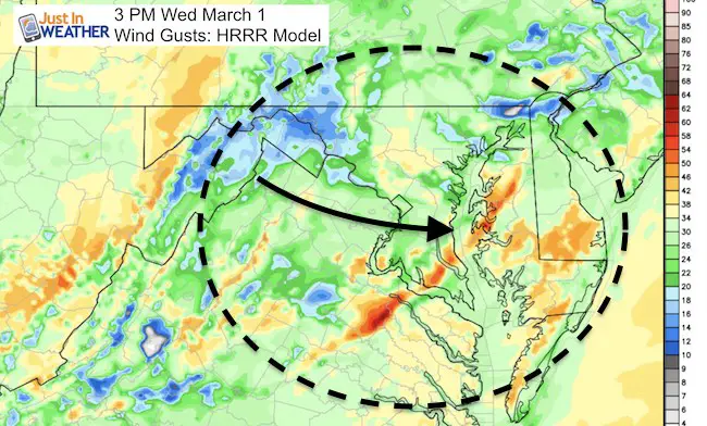
Radar Simulation —> slider HRRR Model
Peak activity will be 2 to 4 PM. Baltimore gets it around 3 PM
Click here to see: Live Interactive Radar
It is important to note that not all storms will turn severe. The slight and enhanced risk plots are based on the potential any individual storm will turn severe. Please keep this in mind during the day as well…
Note: Should there be any severe storms, sleep these terms in mind
Severe Thunderstorm: Storms with wind gusts over 58 mph an or large hail over 1 inch in diameter.
Watch: Potential for a region. Usually a 6 hour window
Warning: Tracking actual severe storms. This usually last 30 to 45 minutes and issued per county.
The most likely element will be Damaging Winds over 58 mph
Winds
The line is not the cold front… and winds will remain high with the risk of more showers.. but the most intense winds will be along the storm line and peak for 10 to 20 minutes
 Get the award winning Kid Weather App I made with my oldest son and support our love for science, weather, and technology. Our 3 year anniversary of the release and our contribution to STEM education is this November. It has been downloaded in 60 countries, and works in both temperature scales. With your support we can expand on the fun introduction to science and real weather.
Please share your thoughts, best weather pics/video, or just keep in touch via social media
-
Facebook: Justin Berk, Meteorologist
-
Twitter: @JustinWeather
-
Instagram: justinweather
Faith in the Flakes Online- Flannel PJs Printed Inside Out
Store Now Open

- We’ve added Flannel PJ Pants that will be printed inside out. They have to be, to make it snow ?
- Free Personal Delivery for orders of 20 items or more to schools and businesses.
- Click this image for the online store.
- Look for more items to be added soon.
- Also see the info for the STEM Assembly Spirit Wear program: Put your school name on the shirts and raise money for you PTO/PTA in the process.
Sign up for email updates on new posts
Since you may miss some posts via social media, click here for email alerts as a way to make sure you don’t miss any. *You may have to refresh that page once for your browser to clear out the images.
FITF SNOW STICKS
 Available in 2 Ft, 30 Inches, and 3 Ft Sizes. Also with Orange/Black or Purple/Black. Click on the image to see the options offered by my friend Thatcher at Signs By Tomorrow in Timonium.
Go to http://www.signsbytomorrow.com/timonium/ to order yours today! Click the ‘Request a Quote’ button at the top of the page. In comment box include color, size and payment information. Please indicate whether you’d like to have us UPS ship them to you or if you would like to pick up in our store. Snow Sticks will ship or will be ready for pick up in our store 48 hrs after order is placed, Mon-Fri.
Also See:
My Winter Outlook for 2016-2017: Colder with snow spread out more
NOAA Winter Outlook for 2016 to 2017
La Nina Formed: What it could mean to our winter
Farmers Almanacs Split On Cold And Snow
Extreme Weather of 2015 balanced out on both ends
Low Snow Winters In Baltimore: Records Might Surprise You