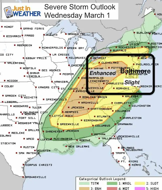
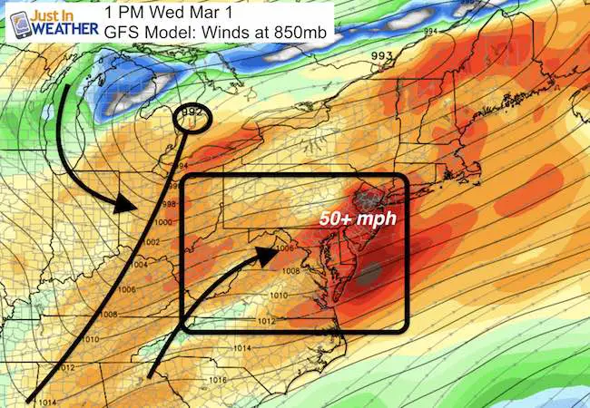
 March 1 – March is coming in like a lion for sure. A band of rain this morning may clip Baltimore and will reach the northern areas of Maryland and into PA. Then the surge of temps back to the 70s and a strong line of storms are likely to turn severe. The NOAA Storm Prediction Center has pushed the Enhanced Risk of Severe Storms farther east to include Westminster and York. This is a better likelihood of storms that could include winds gusting over 58 mph, large hail over 1 inch in diameter, and an isolated tornado is possible. Much of the rest of our area is in the slight risk for severe storms. Below is a timeline on the radar simulation that shows the peak activity will be between 1 and 3 PM.
Please keep scrolling below for much more info on the storms and shift on Friday to light snow.
Simulated Radar —> slider HRRR Model
The most active storms will be between 1 and 3 PM. A chance of rain will linger through the evening.
Severe Storm Breakdown
It is important to note that not all storms will turn severe. The slight and enhanced risk plots are based on the potential any individual storm will turn severe. Please keep this in mind during the day as well…
Note: Should there be any severe storms, sleep these terms in mind
Severe Thunderstorm: Storms with wind gusts over 58 mph an or large hail over 1 inch in diameter.
Watch: Potential for a region. Usually a 6 hour window
Warning: Tracking actual severe storms. This usually last 30 to 45 minutes and issued per county.
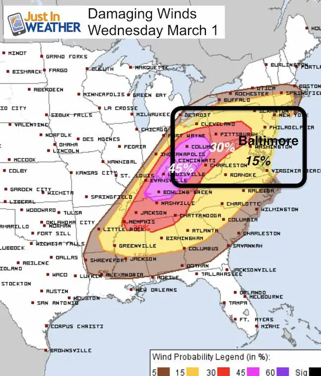
The most likely element will be Damaging Winds over 58 mph
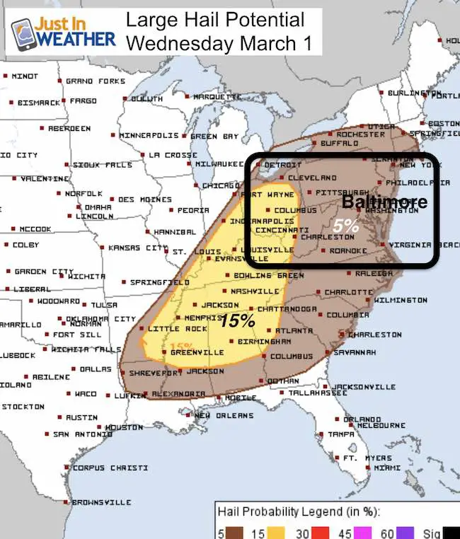
Large Hail over 1 inch diameter
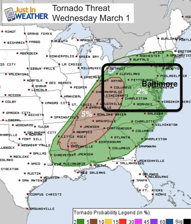
While there is a mention of an isolated tornado, the threat is 2% in any individual storm reaching those parameters
Severe Storms Well Ahead Of Cold Front that should arrive tonight.
Larger View Of Storm
GFS Model —> slider
[metaslider id=43800]
Clipper Type System: Light Snow Friday
—> slider GFS Model
Note: There is little chance for road stickage due to the warm ground and light snow. But some flakes may lay and stay on the grass
[metaslider id=43809]
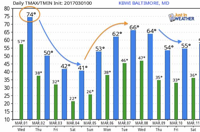
Temperature Outlook
The coldest air will be Saturday, then another warm up next week. I think the month of March will fluctuate like this a lot
 Get the award winning Kid Weather App I made with my oldest son and support our love for science, weather, and technology. Our 3 year anniversary of the release and our contribution to STEM education is this November. It has been downloaded in 60 countries, and works in both temperature scales. With your support we can expand on the fun introduction to science and real weather.
Please share your thoughts, best weather pics/video, or just keep in touch via social media
-
Facebook: Justin Berk, Meteorologist
-
Twitter: @JustinWeather
-
Instagram: justinweather
Faith in the Flakes Online- Flannel PJs Printed Inside Out
Store Now Open

- We’ve added Flannel PJ Pants that will be printed inside out. They have to be, to make it snow ?
- Free Personal Delivery for orders of 20 items or more to schools and businesses.
- Click this image for the online store.
- Look for more items to be added soon.
- Also see the info for the STEM Assembly Spirit Wear program: Put your school name on the shirts and raise money for you PTO/PTA in the process.
Sign up for email updates on new posts
Since you may miss some posts via social media, click here for email alerts as a way to make sure you don’t miss any. *You may have to refresh that page once for your browser to clear out the images.
FITF SNOW STICKS
 Available in 2 Ft, 30 Inches, and 3 Ft Sizes. Also with Orange/Black or Purple/Black. Click on the image to see the options offered by my friend Thatcher at Signs By Tomorrow in Timonium.
Go to http://www.signsbytomorrow.com/timonium/ to order yours today! Click the ‘Request a Quote’ button at the top of the page. In comment box include color, size and payment information. Please indicate whether you’d like to have us UPS ship them to you or if you would like to pick up in our store. Snow Sticks will ship or will be ready for pick up in our store 48 hrs after order is placed, Mon-Fri.
Also See:
My Winter Outlook for 2016-2017: Colder with snow spread out more
NOAA Winter Outlook for 2016 to 2017
La Nina Formed: What it could mean to our winter
Farmers Almanacs Split On Cold And Snow
Extreme Weather of 2015 balanced out on both ends
Low Snow Winters In Baltimore: Records Might Surprise You