Tornado Confirmed in York And More Storms Mid Week
Monday Feb 27 - We have a chilly start to the week as temperatures have dropped below freezing in many places. Another warm up is on the way with a

Monday Feb 27 - We have a chilly start to the week as temperatures have dropped below freezing in many places. Another warm up is on the way with a

Noon Saturday February 25 - We have a slight risk for severe storms this afternoon as a strong cold front passes through our region. At noon, the conditions do support

Saturday February 25 - A strong cold front will pass through today and sweep out this pre-spring airmass. Temperatures area already into the 60s, and will jump up ahead of

Sunday August 21 - A line of strong storms formed as expected this afternoon, but we only had a marginal threat of them turning severe. They did. A waterspout was

Sunday August 21 - Rain has already developed this morning well ahead of the cold front. You may have noticed the increasing wind along with some showers, if not then
Thursday July 28 - It was a matter of time that the heat wave would break down and fold up shop. Today might be the last day we hit the

Monday July 25 - This morning at 7 AM, the temperature at BWI was 79°F which is 5 degrees warmer that the same time on Sunday. On that pace, temps
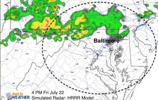
Friday July 22 - It's mid summer and we have a heat wave building. That should be expected and not a headline. But the famed Heat Dome across the nation

Monday July 18 - We have another cold front on the way today. Ahead of it, the heat and some humidity will surge back in. Temperatures will be in the
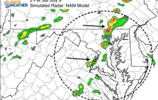
Saturday July 9 - We still have high humidity around this morning. A weak front will trigger some storms this afternoon that will help bringing a slight improvement for tomorrow.