Sever Thunderstorm Watch Today But Better Chance In Maryland Tonight June 3
Wednesday June 3 2020 A Severe Thunderstorm Watch has been issued until 3 PM. This follows a cluster of storms in central PA dropping to the southeast. The primary risk

Wednesday June 3 2020 A Severe Thunderstorm Watch has been issued until 3 PM. This follows a cluster of storms in central PA dropping to the southeast. The primary risk

Wednesday June 3 2020 It's going to be hot and humid today, perhaps the first 90s for many areas. The severe storm risk is coming into focus and today the

Tuesday June 2 2020 As if we didn't have enough going on, the weather is going to make some headlines. A few rain showers have reached the region this morning,

Sunday May 31 2020 We are about to close out another month, that last week was the second coolest on record. That modified quite a bit with very warm weather.
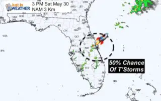
Saturday May 30 2020 One cold front has passed with only parts of the region getting in on the storms yesterday. The humidity has dropped a little, but it will
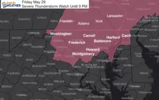
Friday May 29 2020 The heat and humidity have already develop strong and severe storms in our region. More are in the way. This was expected (see my morning report),

Friday May 29 2020 The humidity is about to break after one more hot and steamy day. The ingredients are with us to help feed developing storms this afternoon in

Thursday May 28 2020 You will definitely notice the muggy feel in the air. The remnant Low of Tropical Storm Bertha is moving into Ohio, but dragging very humid air

Wednesday May 27 2020 The second named tropical system of the year just made landfall near Mount Pleasant South Carolina. Tropical Storm Bertha has quickly increased winds to 50 mph,

Wednesday May 27 2020 This morning's weather is more humid and the fog reaches farther inland that before. The Dense Fog Advisory remains in place for much of Delmarva through 10