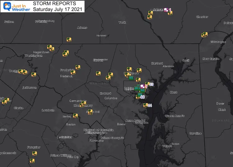
The break of the heat wave on Saturday July 17 came with strong and severe storms. The primary issue was that some storms were very slow movers. The result was flash flooding in pockets around central Maryland, while others missed out completely.
Here is a quick look at some of the rain and damage reports, storm videos, large hail, and amazing lightning photos.
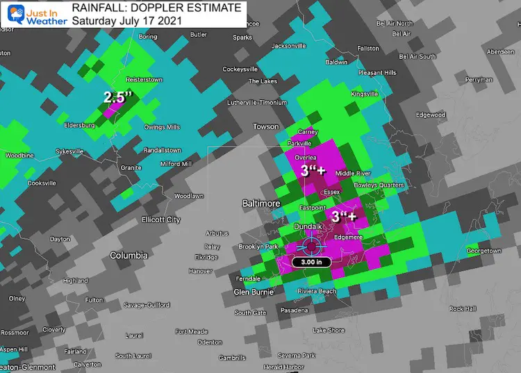
Rainfall
Rainfall topped 3 inches in some of the cells on the east side of Baltimore.
Another cluster topped 2 inches between Eldersburg and Reisterstown
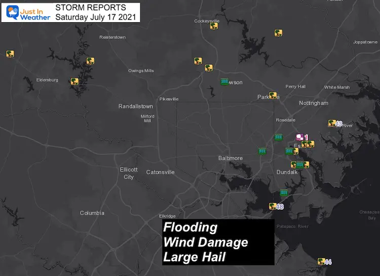
Storm Damage Reports
Here we see the cluster of Flooding Rain, Wind Damage, and Large Hail in the same areas where the heaviest rain fell.
Storm Damage: Blackjack Trucking
Look closely and you will see the hammer drop at the end. That is quite profound…
Thank you Jennifer Brienza Shiflett for sharing this with me. In her words:
“If you’ve been to our truck yard, then you know the big Sycamore tree that sat dead center where we parked our trucks. It was a big old guy that had been there for decades. It was so sturdy, we had a surveillance camera mounted to that tree. That camera recorded the mighty tree’s final moments in tonight’s storm.”
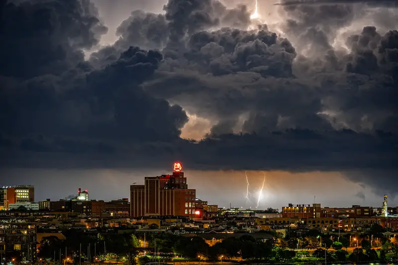
Lightning Photos:
There were a lot of amazing photos of the storm. The new version of this web site will allow for an easier way to share all of them. But since that is still one month away, I wanted to at least show two great storm pics from my friend Tim Shahan from Silo Point over downtown Baltimore.
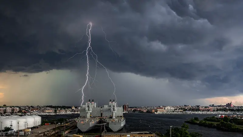
I could not decide which lightning image was more impressive.
Radar: Storms Developing Between 12:30 PM and 3:00 PM
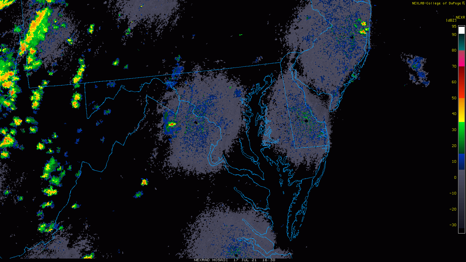
Wider View Map
Storm Report List
This list was created in a different format and copied here. I hope it displays on your device.
| 2021/07/17 08:08 PM | 6 SSE FISHING CREEK | ANZ534 | MD |
| [SOURCE: BUOY; CWA: LWX ] | |||
| 2021/07/17 07:11 PM | MOUNT PLEASANT | FREDERICK | MD |
| TREE DOWN ON MD-26 NEAR CRUM ROAD. [SOURCE: 911 CALL CENTER; CWA: LWX ] | |||
| 2021/07/17 07:10 PM | 1 WSW THURMONT | FREDERICK | MD |
| TREE DOWN ON FOXVILLE RD WEST OF PRYOR RD [SOURCE: 911 CALL CENTER; CWA: LWX ] | |||
| 2021/07/17 05:58 PM | 1 NW SMITHSBURG | WASHINGTON | MD |
| FOUR TELEPHONE POLES AND WIRES DOWN ON LEITERSBURG SMITHSBURG ROAD. [SOURCE: 911 CALL CENTER; CWA: LWX ] | |||
| 2021/07/17 05:01 PM | 3 NNW FRIENDSVILLE | GARRETT | MD |
| TREE DOWN ON STANTON FRIEND ROAD. [SOURCE: 911 CALL CENTER; CWA: LWX ] | |||
| 2021/07/17 04:28 PM | 2 E ROCKVILLE | MONTGOMERY | MD |
| LARGE BRANCH DOWN ON POWER LINES ON GRUENTHER AVE BETWEEN MARSHALL AVE AND BROADWOOD DRIVE. [SOURCE: TRAINED SPOTTER; CWA: LWX ] | |||
| 2021/07/17 04:13 PM | GAITHERSBURG | MONTGOMERY | MD |
| TREE AND WIRES DOWN ON GLEN MILL ROAD NEAR JOINERS LANE. [SOURCE: 911 CALL CENTER; CWA: LWX ] | |||
| 2021/07/17 04:02 PM | 2 SSE ROSEDALE | BALTIMORE | MD |
| TREE DOWN ON MD-150 (EASTERN AVE) NEAR DIAMOND POINT ROAD. [SOURCE: TRAINED SPOTTER; CWA: LWX ] | |||
| 2021/07/17 03:43 PM | 2 SSW MONTGOMERY VILLAG | MONTGOMERY | MD |
| TREE DOWN ON MIDCOUNTY HIGHWAY. [SOURCE: DEPT OF HIGHWAYS; CWA: LWX ] | |||
| 2021/07/17 03:40 PM | 1 WNW ESSEX | BALTIMORE | MD |
| TWO TREES FELL ONTO AN APARTMENT BUILDING ON GARDEN DRIVE CAUSING SIGNIFICANT STRUCTURAL DAMAGE. [SOURCE: 911 CALL CENTER; CWA: LWX ] | |||
| 2021/07/17 03:31 PM | 2 ESE WINFIELD | CARROLL | MD |
| TREE DOWN ON BUSHEY ROAD NEAR OLD WASHINGTON ROAD. [SOURCE: DEPT OF HIGHWAYS; CWA: LWX ] | |||
| 2021/07/17 03:30 PM | 2 ESE ROSEDALE | BALTIMORE | MD |
| [SOURCE: TRAINED SPOTTER; CWA: LWX ] | |||
| 2021/07/17 02:46 PM | LONG GREEN | BALTIMORE | MD |
| MULTIPLE TREES DOWN IN AND AROUND LONG GREEN. [SOURCE: 911 CALL CENTER; CWA: LWX ] | |||
| 2021/07/17 02:24 PM | 1 ENE BROOKLANDVILLE | BALTIMORE | MD |
| TREE DOWN ON A VEHICLE NEAR CLEARFIELD COURT AND TALLY HO ROAD. [SOURCE: 911 CALL CENTER; CWA: LWX ] | |||
| 2021/07/17 02:16 PM | 2 ESE ROCKVILLE | MONTGOMERY | MD |
| TREE AND POWER LINES DOWN ON VEHICLE. [SOURCE: BROADCAST MEDIA; CWA: LWX ] | |||
| 2021/07/17 02:10 PM | 1 SSE OAKLAND | CARROLL | MD |
| TREE DOWN ON OAKLAND MILLS ROAD NEAR LIBERTY ROAD. [SOURCE: 911 CALL CENTER; CWA: LWX ] | |||
| 2021/07/17 01:42 PM | 2 NE OAKLAND | BALTIMORE | MD |
Large Hail:
Quarter size or 1 inch in diameter. If you look closely, you can see the layers made with each trip up and down the clouds.
Larger than a quarter…
🧊 #hail justifying the ‘severe storm’ in Essex MD.
Photo from MaryBeth Waggoner@NWS_BaltWash @TonyPannWBAL pic.twitter.com/02km4Ribie— Justin Berk (@JustinWeather) July 17, 2021
Clouds Swirling Are Not Always A Tornado
Rotation, but not a tornado here…
🔄☁️🚫🌪
🗺 Perry Hall, MD
🕒 Before 3 PM
Thx Keith Boblits.
*Back/forth at end to enhance effect.
There can be cyclonic spin or eddies in the clouds that are not tornadoes.
Definitely a lot of turbulence!@NWS_BaltWash @TonyPannWBAL pic.twitter.com/IETdWwdHtm— Justin Berk (@JustinWeather) July 18, 2021
Maryland Trek 8 Begins on August 8
329 Miles From Wisp To Ocean City
To Honor Kids In Cancer Treatment and Support FREE Programs At Just In Power Kids
![]()
Still Time To Sponsor Our Team
Keep our expenses low.
Click Here to Help with Lodging, Meals, and Fuel

Sunshine State Of Mind
I am done with the cold and snow (for the season). I am embracing my wife’s mantra of Sunshine State of Mind.
This was designed by Shannon Berk and we will be wearing it through spring and to the beach.
Double Benefit: Proceeds will be split between our nonprofit Just In Power Kids and the development of my new weather website. That has been scheduled to be ready to launch in May.

14 Local Maryland Pages (and York PA)
We have made a page for Maryland Weather which gives you the current conditions for 14 present area locations.

Please share your thoughts, best weather pics/video, or just keep in touch via social media