Tuesday May 4 2021
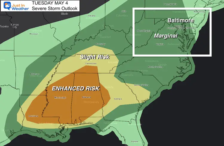
We are set up with the potential for another round of strong to severe storms this afternoon and evening. Below is a comparison of two computer model simulations that both show a strong cluster moving into metro Baltimore between 6 PM and 8 PM.
Let’s hope to not have a repeat of consecrated tornado warnings, but there is a very small risk for that. However we will have a greater potential for storms to contain dangerous lightning, flash flooding, wind gusts to 60 mph, and large hail
Before looking at the model simulations, I wanted to check out the conditions at the time of this post (1 PM). Also what we all can look for to see if this will play out or not.
Radar Snapshot: 1 PM
This cluster we expect is passing through western Maryland here.

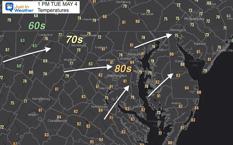
Temperatures: 1 PM
There is a distinct cool down behind the storms moving into the mountains. The contrast of cool air bumping into the warm and humid air we have in metro areas should normally feed into the storms as they move east.
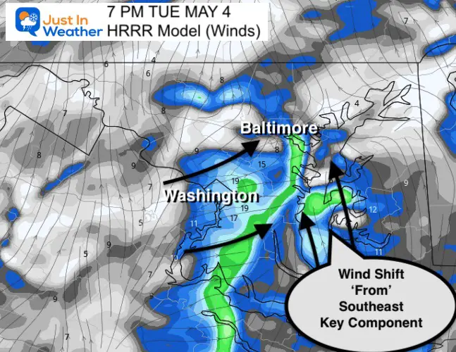
I’ve annotated the wind flow streamlines as well.
Wind Shift Needed
Winds are currently from the West-Southwest. That direction blows over the mountains and can break up storm lines or shift them north of Baltimore. This is because the winds ride along the ridges and try to skip the lower elevations.
Forecast Winds:
The HRRR Model shows the subtle and quick shift ‘from’ the southeast along the Bay just ahead of the storms.
- IF this develops, the chance of storms will be greater.
- IF winds remain form the west/southwest, the storms are likely to weaken, and or shift west and north of the cities.
Radar Simulations and Live Radar
I’ve placed the radar between the two simulations so it is easy for you to scroll and compare.
HRRR Model —-> slider


Live Radar and Lightning
NAM 3 Km Model —-> slider

Sunshine State Of Mind
I am done with the cold and snow (for the season). I am embracing my wife’s mantra of Sunshine State of Mind.
This was designed by Shannon Berk and we will be wearing it through spring and to the beach.
Double Benefit: Proceeds will be split between our nonprofit Just In Power Kids and the development of my new weather website. That has been scheduled to be ready to launch in May.

14 Local Maryland Pages (and York PA)
We have made a page for Maryland Weather which gives you the current conditions for 14 present area locations.

Please share your thoughts, best weather pics/video, or just keep in touch via social media