Press Release: World Meteorological Organization. See my report of the USA tracks and local impacts of last year’s hurricane season below.
Geneva, 17 March 2021 – The World Meteorological Organization’s Hurricane Committee has retired Dorian (2019) and Laura, Eta and Iota (2020) from the rotating lists of Atlantic tropical cyclone names because of the death and destruction they caused. It also decided that the Greek alphabet will not be used in future because it creates a distraction from the communication of hazard and storm warnings and is potentially confusing.

The Hurricane Committee, which serves North America, Central America and the Caribbean (WMO Regional Association IV), agreed to the changes in its naming convention at its virtual session from 15 to 17 March. The meeting reviewed the record-breaking 2020 Atlantic season and fine-tuned preparations for 2021, including the provision of forecasts and warnings, as well as impact assessments, for wind, storm surge and flooding hazards.
Members of the Hurricane Committee, who are from National Meteorological and Hydrological Services throughout the region, discussed the formation of named storms prior to the official start of the hurricane season on 1 June. But the committee agreed that there will be no changes to the official start date of the Atlantic hurricane season in 2021.
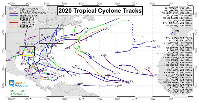
The 2020 season got off to an early and rapid start with a record nine named storms from May through July. It ended late, with two major hurricanes in November for the first time on record and at a time when the season is normally winding down. The season was so active that WMO’s 21-name rotating list was exhausted and the Greek alphabet was used for only the second time (the first time was in 2005).
Named Tropical Storm and Hurricane Tracks
If viewing on a phone, turn sideways or pinch to zoom for larger view
See below for a closer look at the USA and local tracks/impacts

“The RA-IV Hurricane Committee’s work is critical to keep our nations coordinated well before the next storm threatens”, said Ken Graham, Hurricane Committee Chair and National Hurricane Center Director. “Hurricanes don’t care about international boundaries. We all face similar dangers from tropical systems. Impacts from a single storm can affect multiple countries, so it is critical we have a plan, coordinate our efforts, and share challenges and best practices”.
Although the naming convention is only a small part of the Hurricane Committee’s life-saving work, it attracts the most public attention. Atlantic tropical cyclone name lists repeat every six years unless a storm is so deadly or costly that its name is retired from future lists.
In total,93 names have now been retired from the Atlantic basin list since 1953, when storms began to be named under the current system.
The Hurricane Committee agreed on the retirement of names from 2020, along with 2019, because this was not on the agenda of last year’s Hurricane Committee due to the unfolding COVID-19 crisis.
“Developing countries and small islands in the Caribbean and Central America are increasingly vulnerable to the impacts of tropical cyclones, which can overturn years of socio-economic development in a matter of hours. In 2020, we saw this once again with tragic effect,” says Evan Thompson, President of WMO’s Regional Association for North America, Central America and the Caribbean.
“We cannot prevent this incredible force of nature, but we do have the power to minimize the loss of life and property through cutting-edge forecasts and warnings and strong regional coordination and cooperation,” said Mr Thompson, who head’s Jamaica’s national meteorological service.

2019 – Dorian
Dorian was a Category 5 hurricane (on the Saffir-Simpson Hurricane Wind Scale) and the strongest hurricane to hit the northwestern Bahamas in modern records. Dorian caused catastrophic damage mainly in Abaco and eastern Grand Bahama Islands with total damage estimated at $3.4 billion (USD). More than 75 percent of all homes on the island were damaged. The Inter-American Development Bank (IDB), an agency which the government of the Bahamas asked to conduct a study following Dorian’s trail of destruction, stated that the hurricane left 29,500 people homeless and/or jobless.
Dexter will replace Dorian on the list of names in 2025.
2020 – Laura
Laura was a powerful category 4 hurricane (on the Saffir-Simpson Hurricane Wind Scale) that made landfall near Cameron, Louisiana, accompanied by a devastating storm surge of at least 5 meters (17 feet) above ground level. It was responsible for 47 direct deaths in the United States and Hispaniola, and more than $19 billion in damage.
Leah will replace Laura on the list of names in 2026.
2020 – Eta & Iota
Hurricanes Eta and Iota both made landfall less than two weeks apart during November 2020 in the same area of the Nicaraguan coast just south of Puerto Cabezas. The two powerful tropical cyclones caused extensive flooding in Nicaragua, Honduras and other adjacent Central American countries, resulting in at least 272 fatalities and damage losses of more than $9 billion.
Greek Alphabet
The annual name list has been exhausted on two occasions during the past 15 years, and it is likely that this will occur again in the future.
Hurricane Committee members agreed to create a supplemental list of names A-Z (excluding Q, U, as well as X, Y, and Z on the Atlantic list) that would be used in lieu of the Greek alphabet when the standard list is exhausted in a given season. Names on this list could be retired and replaced, when required. Names beginning with Q, U, X, Y and Z are still not common enough or easily understood in local languages to be slotted into the rotating lists.
The 2020 season showed that there were a number of shortcomings with the use of the Greek alphabet.
- There can be too much focus on the use of Greek alphabet names and not the actual impacts from the storm. This can greatly detract from the needed impact and safety messaging.
- There is confusion with some Greek alphabet names when they are translated into other languages used within the Region.
- The pronunciation of several of the Greek letters (Zeta, Eta, Theta) are similar and occur in succession. In 2020, this resulted in storms with very similar sounding names occurring simultaneously, which led to messaging challenges rather than streamlined and clear communication.
- Impacts from Eta and Iota were severe enough that those names have formally retired by the Hurricane Committee. There was no formal plan for retiring Greek names, and the future use of these names would be inappropriate.
A supplemental list of Atlantic tropical cyclone names in lieu of using the Greek Alphabet was agreed by the committee.
Clusters Of Storm Tracks
I have organized the most relevant tropical storms and hurricanes into a few slide shows below. This may help display the connection to our region and the similarity I’ve identified these clusters:
Atlantic Storms, Gulf/Louisiana, Yucatan, and Nicaragua
East Coast Storms –> slider
Storm List
- Arthur – May 16 to 19: Cape Hatteras then offshore
- Bertha – May 27 to 28: South Carolina then inland west of us.
- Fay – July 9 to 11: Close Coastal
- Isais – July 30 to August 5: Track Through Southern Maryland
- Kyle – August 14 to 16: Cape Hatteras then offshore
Gulf Storms: The Hot Zone!
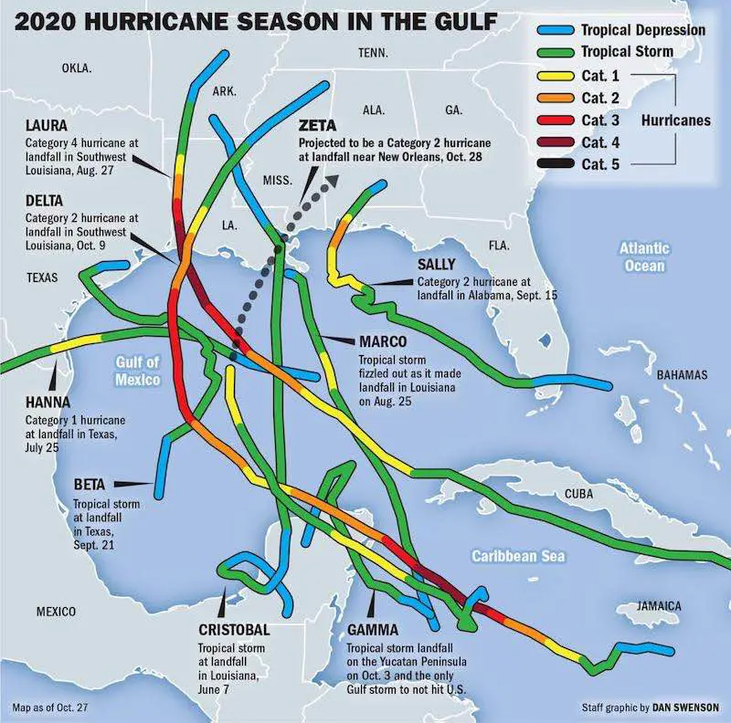
Louisiana Landfalls (5) And Gulf Storms
Image from NOLA was generated on Oct. 27 a day before Zeta made landfall

Gulf/ Louisiana Cluster —> slider
- Cristobal – June 1 to June 9
- Louisiana Landfall Cluster
- Marco – August 20 to 25
- Laura – August 20 to 29
- Sally – September 11 to 17
- *Laura and Sally most similar
- Beta – September 17 to 23
- Delta – October 5 to 10
Yucatan Cluster —> slider
- Marco – August 20 to 25
- Delta – October 5 to 10
- Zeta – October 24 to 29
Marco missed landfall on Mexico. This was 6 to 8 weeks prior. Delta and Zeta hit Cozumel 20 days apart.
Nicaragua Cluster —> slider
- Eta – October 31 to November 13
- Iota – November 8 to 17
*Both storms quickly exploded to major hurricanes in two days, then hit roughly the same area. Both within two weeks of each other.
Local Direct Impacts:
Fay: This was a Close Coastal that moved along the coast quickly and brought flooding to the region. If we have a storm like this in winter, it could be a snow producer near and west of the Bay.

Two Named Storms physically crossed Maryland (St. Mary’s County), while one was downgraded and the remains reached:
Isaias – This crossed St. Mary’s County to Easton then north into the Philadelphia suburbs.

Laura– This was downgraded before reaching us, but the remains crossed southern Maryland.

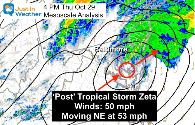
Zeta – This was downgraded to a ‘Post’ Tropical Storm before reaching us, but remains crossed southern Maryland near where Isais passed in St. Mary’s County. *This is key!

14 Local Maryland Pages (and York PA)
We have made a page for Maryland Weather which gives you the current conditions for 14 present area locations.
Please share your thoughts, best weather pics/video, or just keep in touch via social media
Facebook: Justin Berk, Meteorologist
Twitter: @JustinWeather
Instagram: justinweather

