It is a rare day as a weather forecaster to breathe a sigh of relief and still be on pins and needles. The snow that raced in this morning did what I expected, arriving a little earlier than model guidance.
That time window however, put a lot in jeopardy and I want to share a personal story exchange here.
It felt like an overachiever, but the report line up almost perfectly with my call for snowfall with a range of 1 to 4 inches. I am hard on myself with these grades, but this time I trust I deserve an A, and I will explain.
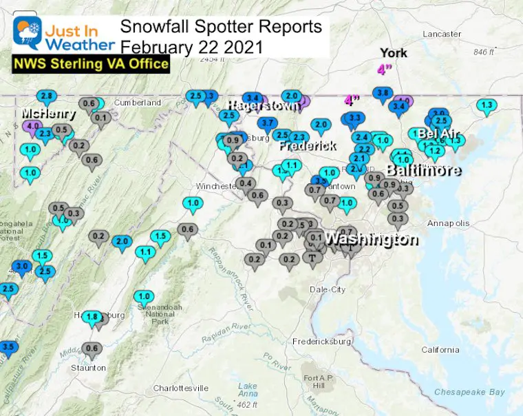
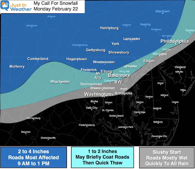
Compare this spotter map to my forecast map. Below I have a personal exchange with a school I consult for to share. Then please Grade My Forecast in the poll, and find the local maps and list of spotters.
NWS Snow Spotter Map
My Call For Snowfall
See the local county maps and spotter lists below
My Reports
I hope my reports all weekend helped. I made sure to emphasize the timing as being critical. A winter forecast can be made or broken by 1 degree or 1 hour. Last week it was that temperature aloft resulting in more sleet than snow. This time it was right in the middle of commute and bussing to schools (in session).
The models kept showing snow reaching metro areas close to 10 AM this morning. I have paid close attention to all of our events and try to find patterns. The one identifiable pattern all winter has been early arrivals, if only by an hour or two.
I hedged my forecast on the arrival closer to 8 AM on the west side of Baltimore, which would maximize the cold temps, stickage, and snowfall. That’s exactly what it did.
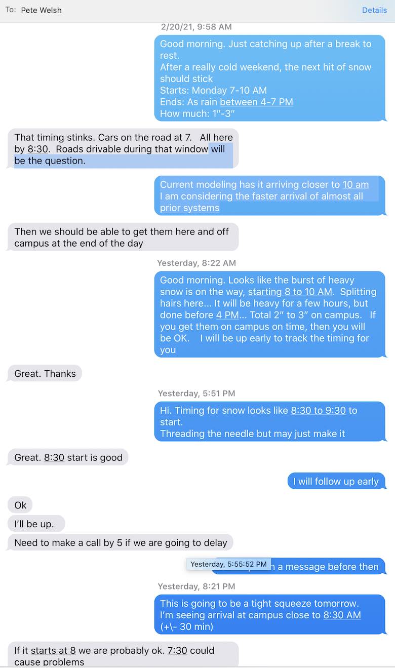
I want to try something different and show you the exchange I had with one of my consulting clients, McDonogh School in Owings Mills. I am in frequent contact with Pete Welsh (especially since Charlie Britton retired). They bus in students from a wide area ranging from near Westminster to Annapolis. Weather conditions can vary dramatically, but impact the entire scheduling.
Here are screen shots of our communication that may help explain the story and thought involved.
Texting with Pete Welsh at McDonogh School
There is a lot of consideration behind the scenes to prepare any needed adjustment to bussing kids to school. I can not speak for all schools, only those I work with. Most schools do only have a local area to worry about.
In the many years I’ve worked with McDonogh School, their large area becomes more complicated in winter and they take safety seriously.
Here is the text communication we had over the weekend and early this morning.
My texts are on the right, Pete’s are on the left…
Saturday/Sunday
Early Monday Morning
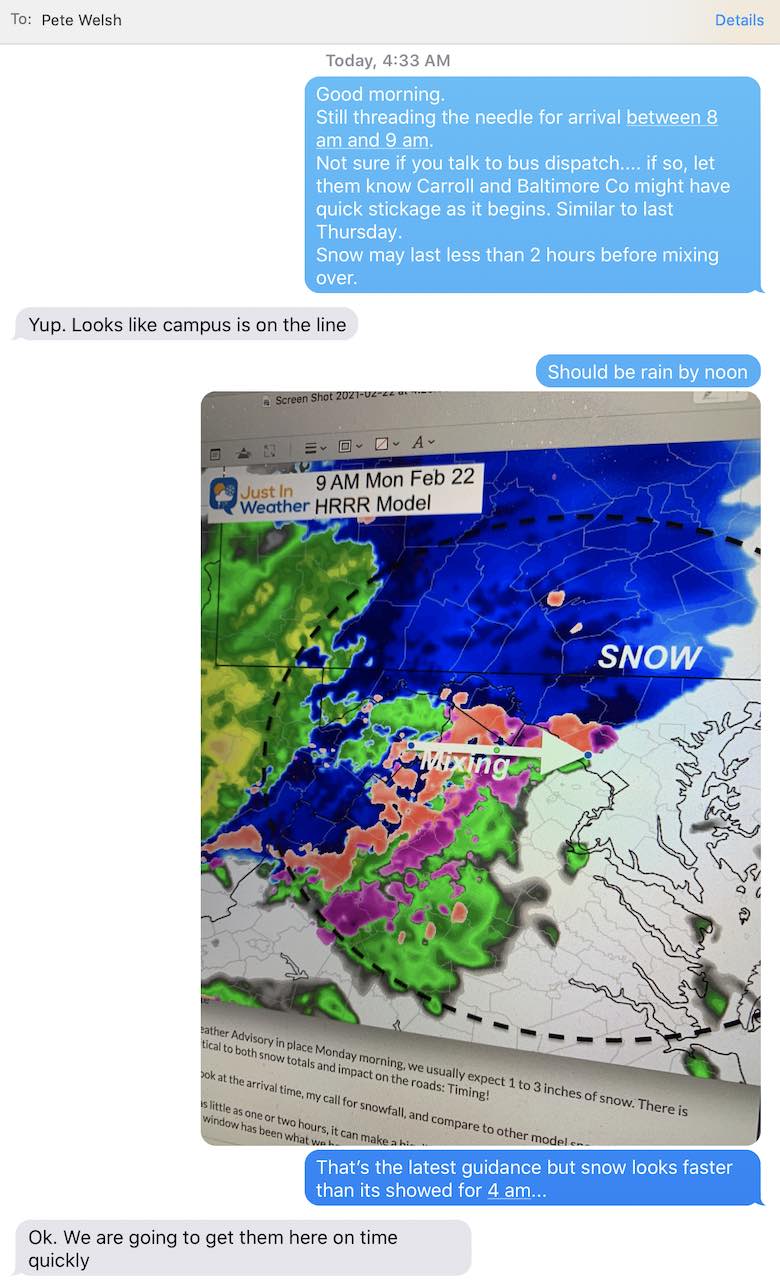
Monday Morning Continued…
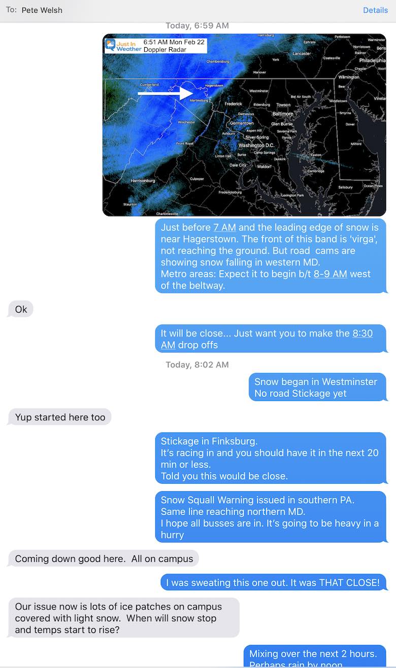
I hope that helps tell another side of the story. At least for what I do with decision support even on toughest mornings fine tuning the timing, and keeping on it all the way.
Please Grade My Forecast For This Event:
Grading Open Until Tuesday Night
“A”
That is the grade I give myself this time. An A!
If you have been keeping track of my snow grading over the last decade, I rarely do this.
Now, I want you to be the judge, or jury, or teacher… You know what I mean…
- Did my reports prepare you for the early timing, travel, and totals?
- In the rain zone? Did you get heavy rain and maybe a rumble of thunder on Delmarva?
See the local Snow Spotter reports below
Grade My Forecast For February 22
- A (77%, 1,349 Votes)
- B (17%, 295 Votes)
- C (4%, 70 Votes)
- F (1%, 24 Votes)
- D (1%, 23 Votes)
Total Voters: 1,761
FITF TUMBLER
READY TO SHIP THIS WEEK
Northeast Maryland Snow
- My Forecast: 2” to 4” near the PA line
- 1” to 2” near I-95 and inland
- Slushy Start But Roads Mostly Wet near the Bay
I KNOW I got you covered this time, even with limited reports to NWS on this map.
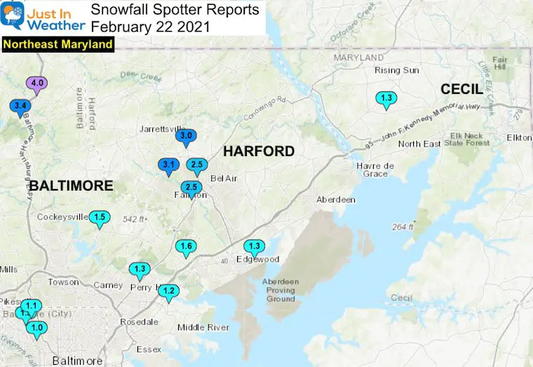
…Cecil County…
Woodlawn 2 ENE 1.3 123 PM 2/22 Trained Spotter
…Harford County…
Forest Hill 3 SW 3.1 1155 AM 2/22 Trained Spotter
Forest Hill 1 NNW 3.0 1200 PM 2/22 Trained Spotter
Bel Air 2 W 2.5 230 PM 2/22 Trained Spotter
Bynum 1 SW 2.5 1251 PM 2/22 Trained Spotter
Abingdon 1 SE 1.3 1112 AM 2/22 Trained Spotter
Baltimore City/County Snow
- My Forecast: 2” to 4” near the PA line
- 1” to 2” near I-95 and inland
- Slushy Start But Roads Mostly Wet near the Bay
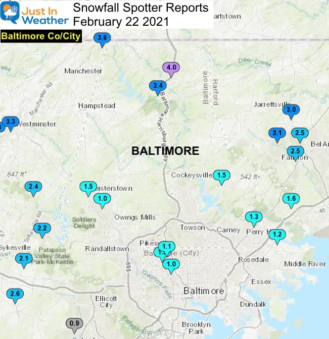
…Baltimore County…
Bentley Springs 1 E 4.0 1200 PM 2/22 Trained Spotter
Parkton 1 W 3.4 1205 PM 2/22 Trained Spotter
Upper Falls 1 NNE 1.6 100 PM 2/22 Trained Spotter
Long Green 2 NW 1.5 1030 AM 2/22 Trained Spotter
Glyndon 1 SW 1.5 952 AM 2/22 Trained Spotter
Perry Hall 1 NNE 1.3 1109 AM 2/22 Trained Spotter
White Marsh 2 E 1.2 1100 AM 2/22 Trained Spotter
Reisterstown 1 ESE 1.0 1003 AM 2/22 Trained Spotter
…Baltimore City…
Pimlico SE 1.5 1045 AM 2/22 Trained Spotter
Pikesville 2 SE 1.1 1020 AM 2/22 CoCoRaHS
Arlington 2 ESE 1.0 1034 AM 2/22 Broadcast Media
North Central Maryland Snow
- My Forecast: 2” to 4” north of I-70
- 1” to 2”south of I-70
- Note: Mt. Airy spans 3 counties and was right on the edge of 2” +/- on the map.
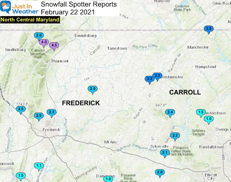
…Frederick County…
Thurmont 3 N 4.5 1015 AM 2/22 NWS Employee
Sabillasville 2 SSE 4.0 100 PM 2/22 Trained Spotter
Bloomfield 2 WSW 2.5 1015 AM 2/22 NWS Employee
Myersville 2 SE 2.5 1200 PM 2/22 Trained Spotter
Bloomfield 1 SE 2.3 1100 AM 2/22 Trained Spotter
Woodsboro 3 E 2.0 1012 AM 2/22 Trained Spotter
Sabillasville 2.0 942 AM 2/22 Trained Spotter
Point of Rocks 1 NE 1.5 1000 AM 2/22 Trained Spotter
Adamstown 1 ESE 1.1 925 AM 2/22 NWS Employee
…Carroll County…
Millers 4 NE 3.8 1203 PM 2/22 Co-Op Observer
Wagners Mill 1 ENE 3.3 1037 AM 2/22 Trained Spotter
Westminster SE 3.3 1145 AM 2/22 Trained Spotter
Gamber 1 WNW 2.4 1117 AM 2/22 NWS Employee
Eldersburg 1 SE 2.2 100 PM 2/22 Trained Spotter
Western Maryland Snow
- My Forecast: 2” to 4”
- Allegany under reported here
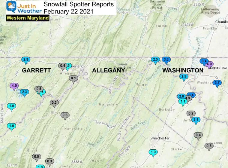
…Garrett County…
McHenry 1 S 4.0 900 AM 2/22 Trained Spotter
Grantsville 5 W 2.8 1215 PM 2/22 Dept of Highways
Deer Park 6 NE 2.3 1015 AM 2/22 Trained Spotter
Bloomington 3 WNW 1.8 1015 AM 2/22 Trained Spotter
Mountain Lake Park 1.0 600 AM 2/22 CoCoRaHS
Warnocks 4 NW 0.5 700 AM 2/22 HADS
…Allegany County…
Frostburg 2 ENE 1.5 106 PM 2/22 Trained Spotter
Frostburg 0.6 700 AM 2/22 Co-Op Observer
Cresaptown-Bel Air 1 0.1 700 AM 2/22 CoCoRaHS
…Washington County…
Long Meadow 1 SSE 4.0 1206 PM 2/22 Trained Spotter
Boonsboro 3 NNE 3.7 1130 AM 2/22 Trained Spotter
Long Meadow 2 W 3.4 1130 AM 2/22 Trained Spotter
Pecktonville 3 NNW 3.3 1100 AM 2/22 NWS Employee
Hancock 1 ESE 2.5 1130 AM 2/22 Trained Spotter
Capital Region Snow
- 1” to 2” northern half.
- Slushy Start But Roads Mostly Wet near the Washington Beltway and I-95
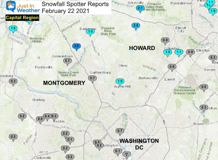
…Montgomery County…
Clarksburg 2 SE 3.5 1251 PM 2/22 Trained Spotter
Norbeck 1 ESE 1.0 1000 AM 2/22 Trained Spotter
Damascus 1 SE 1.0 1210 PM 2/22 Trained Spotter
Germantown 2 WSW 0.7 1230 PM 2/22 Trained Spotter
Rockville 3 NNW 0.7 1247 PM 2/22 NWS Employee
…Howard County…
Glenelg 2 N 2.6 1245 PM 2/22 Trained Spotter
Sykesville 2 SSE 2.1 100 PM 2/22 Trained Spotter
Elkridge 2 W 1.1 1230 PM 2/22 Trained Spotter
Columbia 1.0 100 PM 2/22 NWS Employee
Columbia 2 N 0.9 100 PM 2/22 Trained Spotter
Elkridge 0.9 1130 AM 2/22 NWS Employee
Savage 1 N 0.6 1000 AM 2/22 Trained Spotter
…District of Columbia…
National Zoo 1 WSW 0.7 930 AM 2/22 Trained Spotter
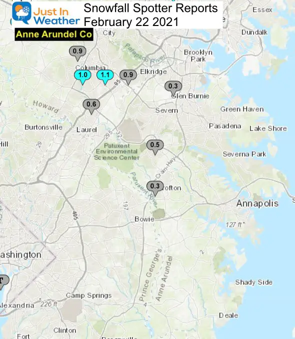
Anne Arundel County Snow
- Dusting to 1 inch near Glen Burnie and BWI
- Slushy Start But Roads Mostly Wet near Annapolis
Southern Pennsylvania Snow
- My Forecast: 2” to 4”
- Mostly we saw 3 to 4 inches. A few hit 5 inches in Adams County
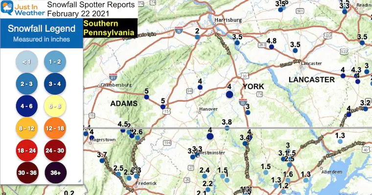
…Adams County…
1 E Mcsherrystown 5.0 in 0345 PM 02/22 Public
Cashtown 5.0 in 1145 AM 02/22 Trained Spotter
Gettysburg 5.0 in 1050 AM 02/22 Public
East Berlin 4.0 in 1135 AM 02/22 Trained Spotter
…York County…
Manchester 4.7 in 0100 PM 02/22 Trained Spotter
1 WNW Stonybrook 4.5 in 0530 PM 02/22 Public
Hanover 4.0 in 0430 PM 02/22 Public
Loganville 4.0 in 0330 PM 02/22 Public
1 S New Salem 3.0 in 0532 PM 02/22 Trained Spotter
2 NNE Shrewsbury 3.0 in 1105 AM 02/22 Trained Spotter
…Lancaster County…
3 NNE Denver 4.8 in 0500 PM 02/22 Public
2 NNE Mount Joy 4.8 in 1236 PM 02/22 Trained Spotter
1 ESE Elizabethtown 4.0 in 0130 PM 02/22 Trained Spotter
Gap 4.0 in 1211 PM 02/22 Trained Spotter
2 NNE East Petersburg 3.5 in 1201 PM 02/22 Broadcast Media
Please share your thoughts, best weather pics/video, or just keep in touch via social media
Facebook: Justin Berk, Meteorologist
Twitter: @JustinWeather
Instagram: justinweather
14 Local Maryland Pages (and York PA)
We have made a page for Maryland Weather which gives you the current conditions for 14 present area locations.

Winter Outlook Series


FITF Shop Open
My ‘bonus’ daughter Jaiden and wife showing off our popular Maryland Hoodies. Unisex and women’s items all produced in Maryland.
Click here to see this and many other new items.

