Wednesday February 10 Afternoon Update
Tonight will be the start of our very active weather pattern. Now that the first system is on our doorstep, it is coming into focus. With some subtle details, I have made a final adjustment to refine my snow map.
It is my hope to give you a better understanding of what you can expect as we see a little more snow north and a little less snow south.
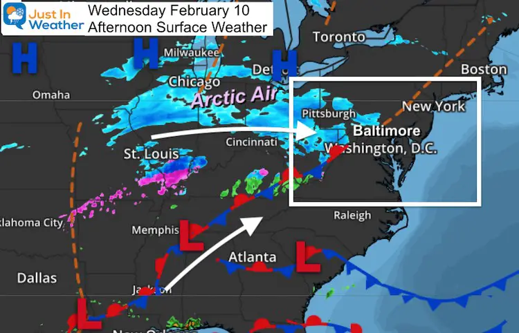
This is all based on where the arctic boundary sets up.
Patience Please: This weather pattern will be trying to give us some many wintry events into next week. It may become hard to keep track, so we must focus on the short term, but I do have maps for the rest below.
- Tonight: Snow
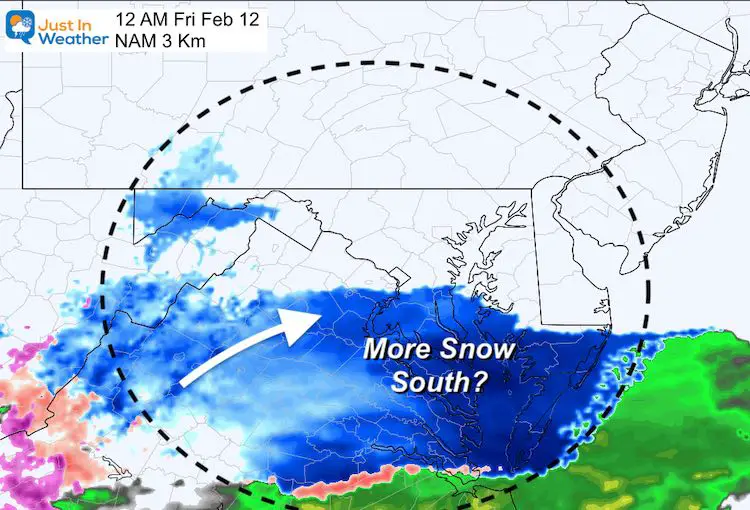
- Thursday Night: Snow (more south?)
- Saturday: Snow/ice, ends Sunday morning
- Tuesday: Ice Storm?
Wednesday Afternoon Set Up
This system looks a little north of original model guidance. That was a point I mentioned before, many times. We have a pattern continuing where where systems are verifying NORTH of model guidance. This will play a role in where it tracks through our area, and perhaps the next few systems.
Our snow will develop 7 PM to 10 PM, and end Thursday morning before noon.
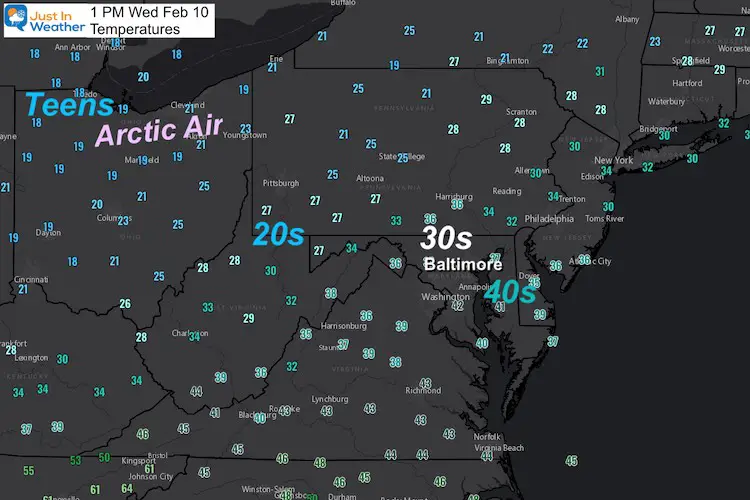
Temperatures
Our region has pushed near 40ºF as expected, but very cold air is just to our west, and trying to move in.
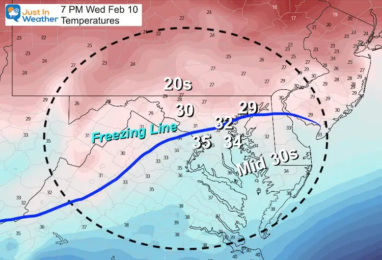
This Evening
At 7 PM the snow will be in the vicinity. It my show up on radar before it reaches the ground… and it could generate some colder air in the process.
The freezing line should be through Baltimore, but north of Washington.
*Northern Maryland AND northern Bay areas: You will be BELOW FREEZING! Contrary to let Sunday, this will allow falling snow to stick.
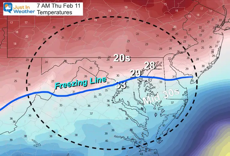
Thursday Morning
At 7 AM the snow will be coming to an end. Slightly colder air will settle in to central Maryland. This keeps Washington and Annapolis on the fence of freezing, but 20s will be widespread to the north.
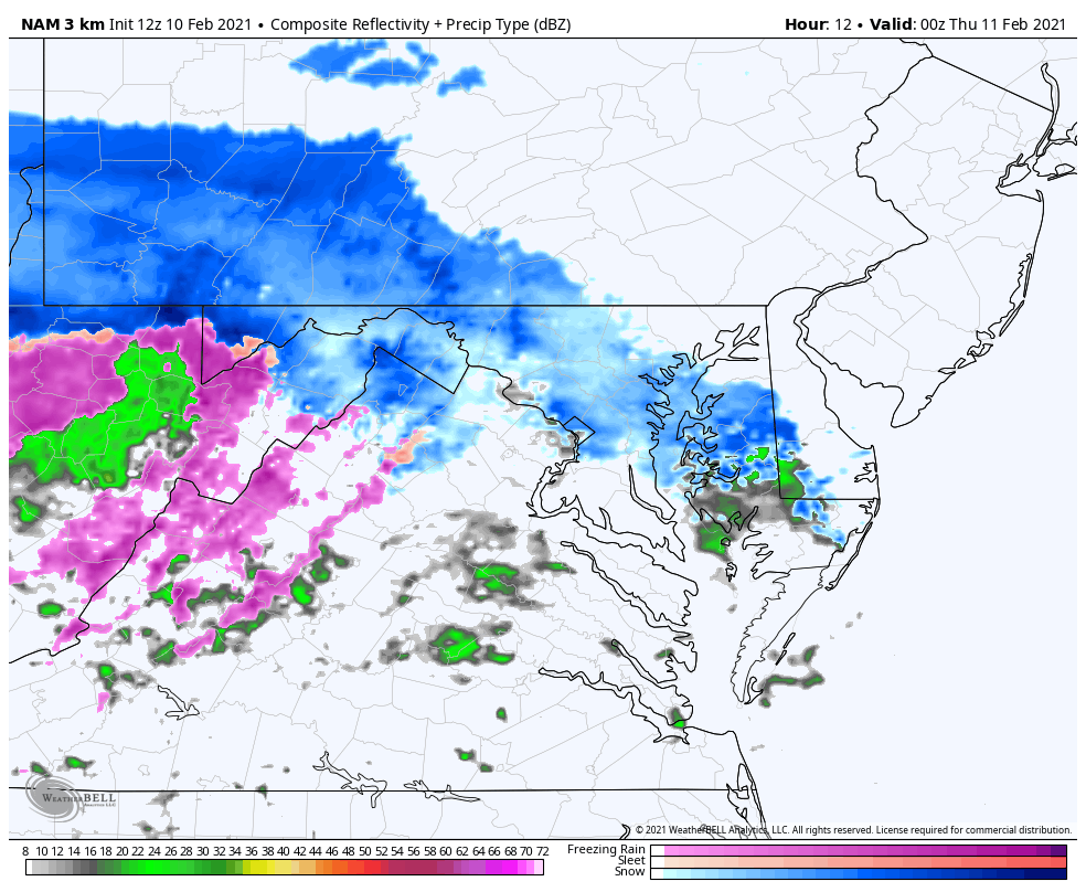
Snow Animation: NAM 3 Km
This high resolution model snows the meandering snow line.
- It is possible that near Route 50 it may start s snow, mix with rain or sleet, then go back to snow. This will change how much snow can fall.
- Southern Maryland: There may be more rain, but end with snow. Hang in there was you might win the snow game Thursday night.
AFTERNOON UPDATE
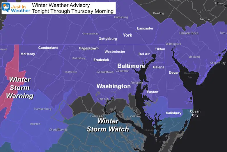
Click to see: NWS upgrades parts of Maryland to a Winter Storm Warning
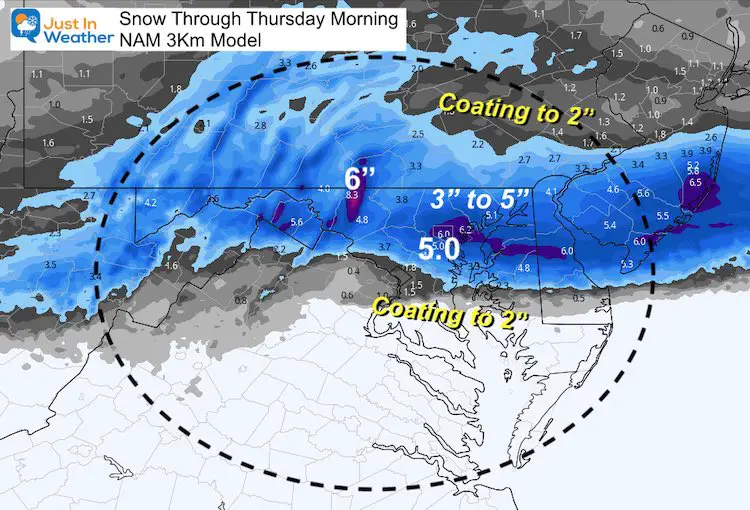
My UPDATED Call For Snowfall
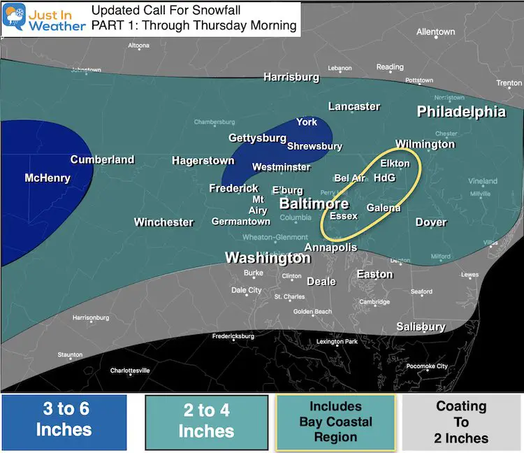
North of Rt 50: Increased snow just a little
- 2 to 4 inches
- Peak Snow: Frederick County to York County. I have them in the 3″ to 6″, but there is model support for more. Temps in the mid 20s will allow for flakes to ‘fluff up’ a bit more.
- The trend has been for this region to be in the bulls eye, so we might as well stick with it.
North Bay Coastal Area:
- Temps will be below freezing this time. That will allow the snow to fall and stick. If you are south of I-95, you may end up closer to the lower end 2″
South of Rt 50
- Washington, Annapolis may start with snow, then mix, then end with snow. That cuts back the potential to 2 inches or less.
Southern Maryland
- May have more rain, and end with snow. Barely a coating expected, but more on the way in Part 2 Thursday night.
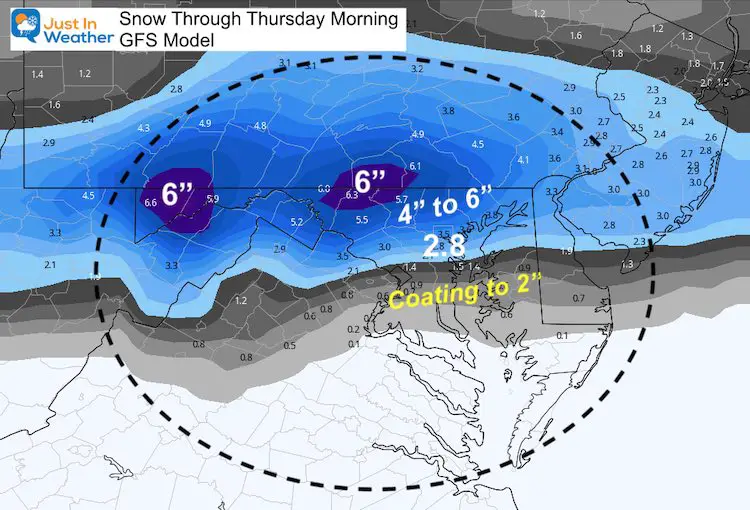
Compare Model Forecasts
Notice these numbers are higher than my call. I purposely stayed a little below the mark for higher confidence.
GFS Model
Canadian Model
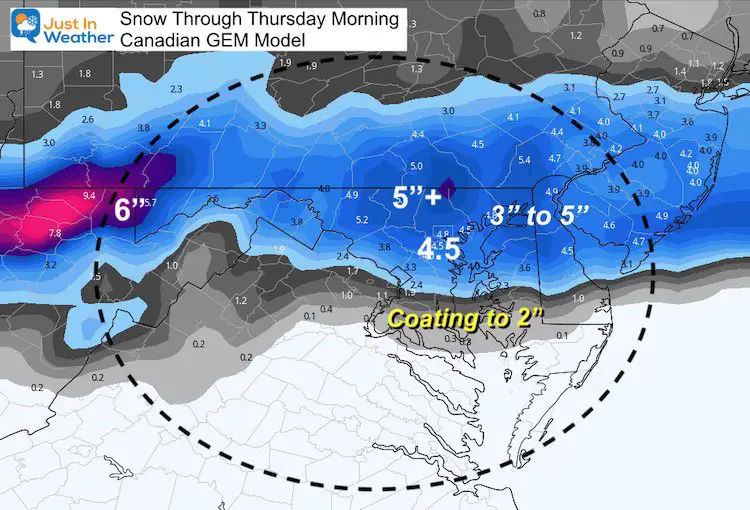
NAM 3 Km Model
Winter Weather Advisory
Winter Storm Watch for Thursday Night in southern Maryland and southeast Virginia.
What’s Next?
Thursday Night:
I am skeptical of this hard southern push given the model bias I mentioned before. The snow should track north to Baltimore, but there will be more snow in Washington, Annapolis, and southern Maryland this Part 2.
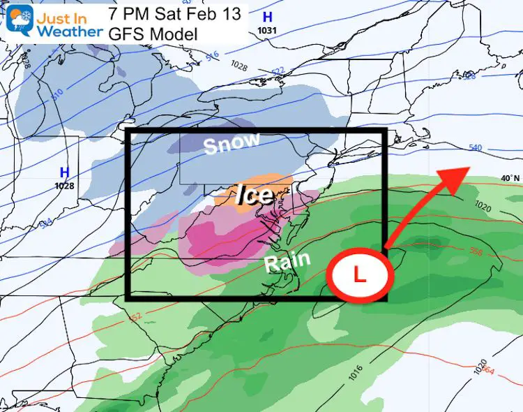
Weekend Storm:
The latest plots show this as an ice storm. This will be a coastal track, but fast moving. This looks like we may be on the edge of the arctic air… I do think the developing snow pack from the next two systems may help us trend a little colder.
Timing: Saturday ending Sunday morning. Just a little faster and earlier than our first look.
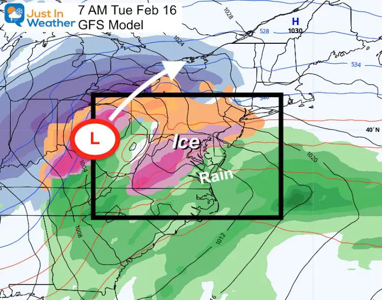
Tuesday: Another Ice Storm? This will be an inland Ohio Valley Low
Depending on the snowpack established over the next few days, we could hold cold longer and have more moisture. This is the storm we don’t want.
Please share your thoughts, best weather pics/video, or just keep in touch via social media
Facebook: Justin Berk, Meteorologist
Twitter: @JustinWeather
Instagram: justinweather
Winter Outlook Series


14 Local Maryland Pages (and York PA)
We have made a page for Maryland Weather which gives you the current conditions for 14 present area locations.


FITF Shop Open
My ‘bonus’ daughter Jaiden and wife showing off our popular Maryland Hoodies. Unisex and women’s items all produced in Maryland.
Click here to see this and many other new items.

