Friday December 18 2020
This is like deja vous, right? Last week I wrote about the recent winter storm and wondering if it was OK to get excited for snow. This time there is more confidence and there is a very simple reason: The Arctic Front!
Arctic Cold Fronts are often easier to forecast than solo storms and ‘phasing’ events. This a large, dense air mass which can be handled better by computer modeling even 7 days away. The real questions will be the timing of the arrival and what amount of moisture will be left behind the front.
The quick version of the outlook:
- Christmas Eve: Mild, with rain.
- At Night: There could be thunderstorms, winds with the front to 50 mph, then a change to snow.
- Christmas Day: Flash Freeze! Some flurries or snow showers and brutally cold air likely falling through the teens.
Let’s take a quick look at all the buzz, then explain a little more about why this is expected to happen.
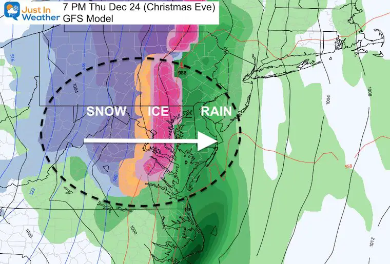
GFS Animation
This reminds me of the Christmas 2002 snow. A warm rain on Christmas Eve was followed by a burst of to 6 inches of wet snow for much of Maryland and southern PA on Christmas morning. I remember because I was working EVERY HOLIDAY SHIFT on WBAL! The night shows, and the morning shows.

Transition From Rain To Ice And Snow
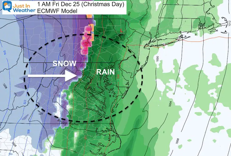
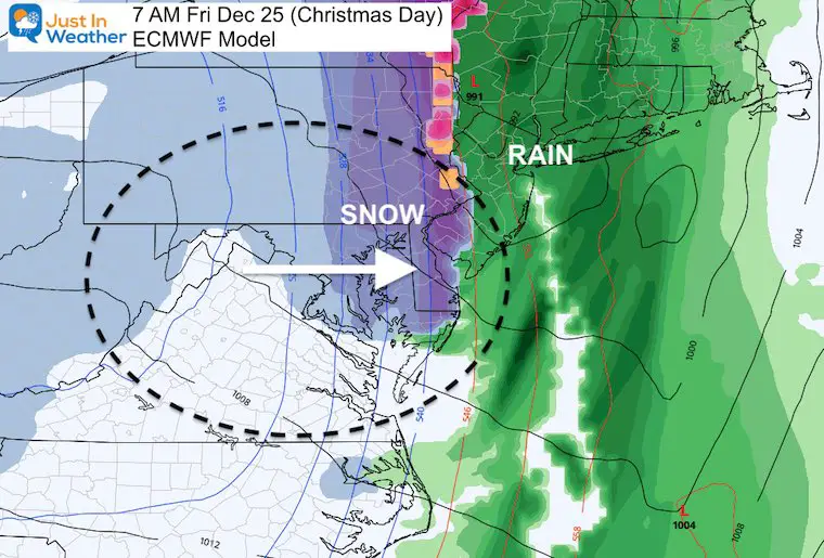
The timing is what is not agreed upon at this time. The GFS is faster, on Christmas Eve Night. But the European Model is slower, arriving early on Christmas morning.
Note: While this is one week away, this type of set up can bring:
Thunderstorms, damaging winds, then a quick drop in temps with sleet and snow. This may all result in a Flash Freeze!
We can see why below…
GFS Model Snapshot
European Model
Later time, but still passed through by morning…
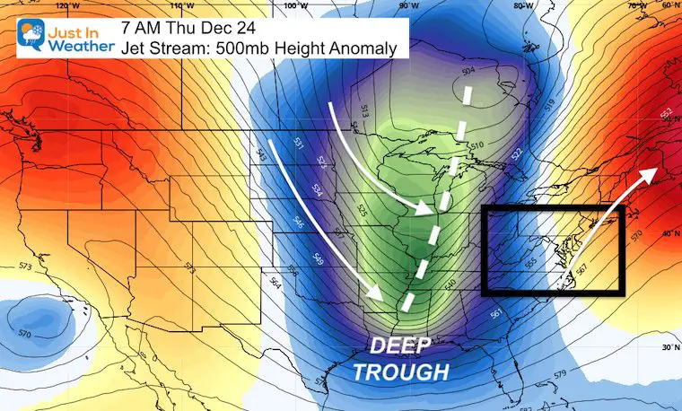
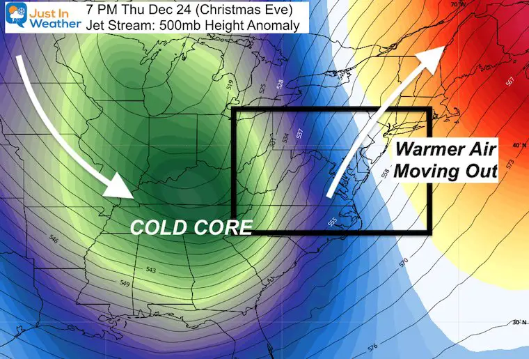
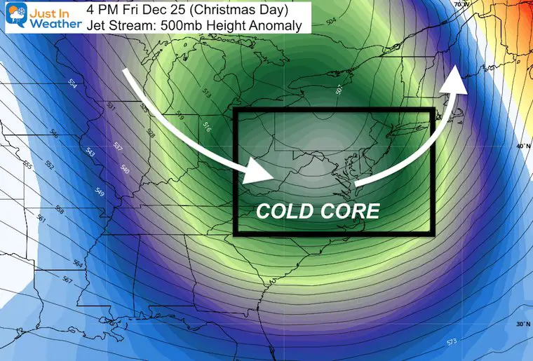
Jet Stream Maps
This is a look at the 500mb level, which is about 18,000 Ft above the ground.
Christmas Eve Day
An extremely deep trough will be digging into the Gulf Coast Region. This will open up air from the arctic to drop all the way south into the US.
We will have warming just ahead of its arrival.
Closer Look
At this time, the cold air will be pushing the warm air out. The contrast may spark strong storms, very strong winds, and a sharp transition from rain to ice and snow.
Christmas Day
The core of the cold air will reach us in the afternoon. Rapidly falling temperatures will resemble the heart of winter.
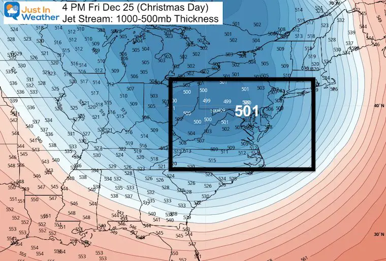
Thickness between 1000 mb and 500mb
This measurement is a good reflection of how cold the air will be. Note: The 540 (dm) line is where we spot the freezing point at cloud level between rain and snow. Here we see 509 (dm) that represents roughly 30 degrees colder. Yes, it should be near or below ZERO aloft in the afternoon.
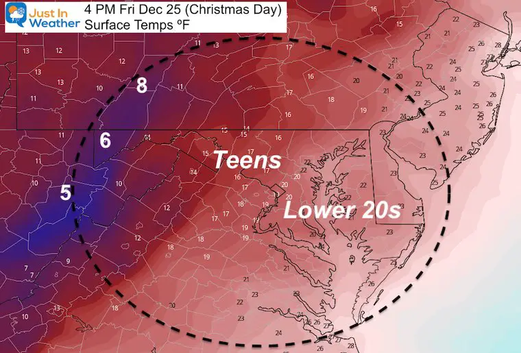
Afternoon Surface Temperatures
Temperatures should be falling all through Christmas Day.
These numbers are for 4 PM in the afternoon!
It will be windy as well, which should take chills down to near or below Zero!
More Support
The long range global patterns support a cold period ahead.
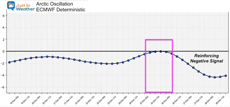
The Arctic Oscillation remains with a negative signal. It will reach near neutral on Christmas, then drop further than it has been in the days that follow.
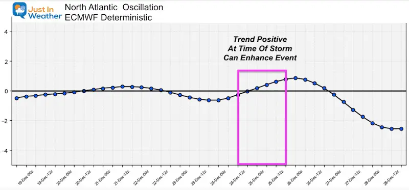
The North Atlantic Oscillation is a prominent signal when negative to support east coast snow. But I have seen many occurrences when it is negative, and while it rises to neutral, we can get a winter event on the east coast of the US.
That’s what we see here on Christmas, then falling deep negative a few days later.
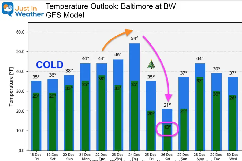
Temperature Outlook
This is an abrupt change. This is also EXTREME! I expect this will adjust and may modify a little as we get closer. But WOW! What an impressive perspective now for Baltimore:
Christmas Eve: 50s
Christmas Day: Falling! That 35ºF would be at midnight, as we’ve seen the afternoon in the lower 20s.
December 26: Highs in the lower 20s!
Notice the temps recover to the upper 30s, still well below average to end the month.
FITF Shop Open
My ‘bonus’ daughter Jaiden and wife showing off our popular Maryland Hoodies. Unisex and womens items all produced in Maryland.
Click here to see this and many other new items.


14 Local Maryland Pages (and York PA)
We have made a page for Maryland Weather which gives you the current conditions for 14 present area locations.

Also see:
Winter Outlook Series


Also See:
December Climate, Sun Data, Solstice, ISS Flyovers, Moon, Planets, and The Great Conjunction

14 Local Maryland Pages (and York PA)
We have made a page for Maryland Weather which gives you the current conditions for 14 present area locations.
Maryland Weather Page
I wanted to keep it simple. Just the basics for a quick view at any time.

Please share your thoughts, best weather pics/video, or just keep in touch via social media
-
Facebook: Justin Berk, Meteorologist
-
Twitter: @JustinWeather
-
Instagram: justinweather
Email Updates
Please make sure you sign up (above or click here to sign up for email alerts…. ) for my newsletter. This way you will get an email to make sure you are notified of each post.
Just In Power Kids:
A portion of proceeds go to our programs Providing FREE holistic care for kids in cancer treatment and up to 5 years post treatment and caregivers.
![]()
New Caps and Hats

