Monday October 26 2020
Big changes this week. We already saw a 30 degree temperature drop from Saturday to Sunday. This morning there is some drizzle and fog, then recover to the 60s for a couple of days.
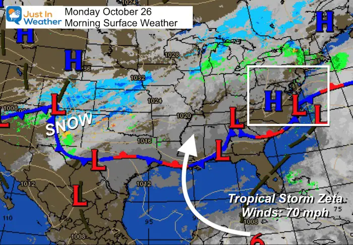
The big story will be the snowstorm in the Southern Rockies entering Texas, while Tropical Storm Zeta flirts with hurricane intensity and aims for the Louisiana coastline. Those will then send us heavy rain later in the week.
Here is first look weather forecast, and NEW GFS Interactive simulation slider. Also see the journal of Maryland Weather conditions observed in Baltimore yesterday, climate report today, sunrise/sunset, moon phase, and daily weather map.
Morning Set Up
Drizzle and fog this morning, but the storm is moving away.
Snow is still falling across Colorado Ito New Mexico, north Texas through Nebraska and Kansas.
Tropical Storm Zeta has winds up to 70 mph and should become a hurricane before reaching Cozumel and Cancun. This is what Delta did a few weeks ago.
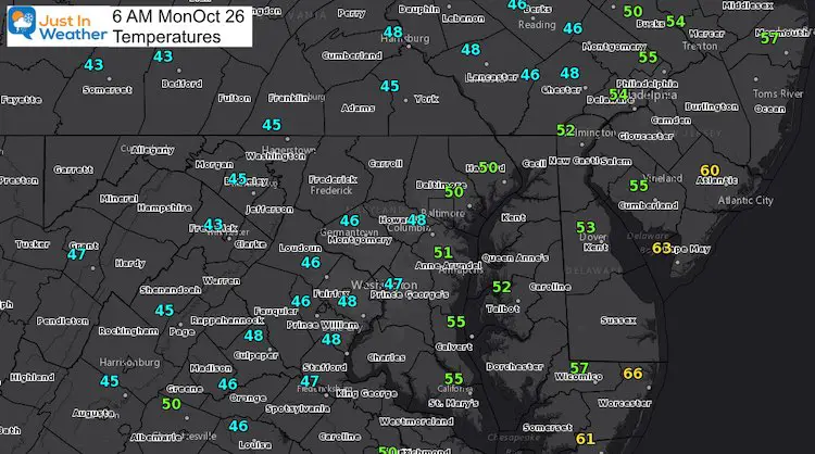
Temperatures
Chilly with some drizzle and fog.
Quick Weather Forecast:
Based on metro Baltimore
YOUR LOCAL WEATHER PAGE LINKS ARE BELOW
The heavy rain from Zeta and the other system will reach us Thursday and Friday.
EXPANDED FORECAST: Click here for more on the combination snow and tropical storm to bring us heavy rain.
NEW: Interactive Temperatures, Rain, and Wind
Try this:
- Use the Orange Button to slide the timeline on your own. Or hit the Play Button at the lower left.
- You can also pinch to zoom or move the map.
Climate Data Update
Observations Yesterday:
Sunday October 25 2020
High = 56ºF at 12:02 AM
Low = 47ºF at 4:01 PM
Rainfall: 0.09″
Winds from the Northwest
- Top Speed (1 minute average) = 14 mph
- Top Gust (3 to 10 seconds) = 25 mph
- Average Wind Speed: 8.3 mph
Please note that humidity and dew point often change each hour like the temperature. These are not recorded as high or low, and can be arbitrary depending on the time you check.
Current Data and Past 72 Hourly Reports
You can get the hourly weather reports for the prior 72 hours at this link:
Baltimore Weather at BWI Past 72 Hours
Today’s Weather
Tuesday Climate Stats:
October 20, 2020 in Baltimore
Average High: 64ºF
Record High: 81ºF in 1978
Average Low: 42ºF
Record Low: 27ºF 1952
Sunrise: 7:28 AM
Sunset 6:12 PM
*Daylight = 2:21 shorter than yesterday.
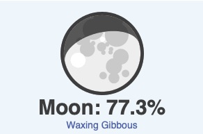
Moon Phase
Also See:
14 Local Maryland Pages (and York PA)
We have made a page for Maryland Weather which gives you the current conditions for 14 present area locations. Many of these match up with the spots on our route. Please use this list below are reference. I will include them daily with my articles on the kids.
Maryland Weather Page
I wanted to keep it simple. Just the basics for a quick view at any time.
Please share your thoughts, best weather pics/video, or just keep in touch via social media
-
Facebook: Justin Berk, Meteorologist
-
Twitter: @JustinWeather
-
Instagram: justinweather
Email Updates
Please make sure you sign up (above or click here to sign up for email alerts…. ) for my newsletter. This way you will get an email to make sure you are notified of each post.
Also See:
Sunflower Season: Millers Farm Photos And Info
Help Solve The Mystery
UFO, Meteor, Or Something Else Caught On Cam In Owings Mills MD This Week?
Explore More:
Autumnal Facts and Weather Stats
Record Low Tied at BWI and Frost Photos Sep 20
Typical First Frost and Freeze
Also See:
July 2020 The hottest on record. Will it hint at snow this winter?
Comet NEOWISE Viewing All July (photos/video)
Related Posts
2020 Tropical Storm and Hurricane Names and Naming History
Atlantic Tropical History: Maps of Origin Regions Every 10 Days
Other Links:
Baltimore Weather At BWI May Not Be As Hot As Reported
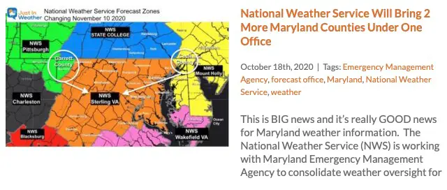
Construction at the airport close to the weather station may be added artificial heat. Click here or the image for the details.
Just In Power Kids:
Proceeds go to our programs Providing FREE holistic care for kids in cancer treatment and up to 5 years post treatment and caregivers.


