Tuesday March 3 2020
Updated at 6:30 PM
A strong cold front is holding energy past sunset to produce some circulating storm cells as they enter our area. The forward speed is 60 mph, so the winds at the surface can be damaging. The worst is passing northern WV and VA into Central Maryland this evening. There will be a large area with a downpour and some lightning, but the risk for hail is small.
At first glance, this complex looks more impressive than the short range modeling, but I included two model simulations below anyway… at least to compare the timing.
Severe Thunderstorm Warning
At 6:15 this was near Berryville and Charlestown. It is moving to the Northeast at 60 mph. That speed itself can carry the momentum for damaging winds.
At 6:35 PM the worst was in Frederick Co between Middletown and Ballenger Creek and New Market.
This warning runs from 6:20 PM to 6:45 PM (so it may be expired and a new one issued east when you read this)
Northwestern Loudoun County in northern Virginia…
Eastern Frederick County in northwestern Virginia…
Central Clarke County in northwestern Virginia…
Southern Jefferson County in the Panhandle of West Virginia…

Wider View Radar
This storm structure covers a brand area. But the worst will hit southern Frederick County, northwestern Montgomery County, and western Howard into Carroll Counties. Mount Air to Westminster should get this by 7 PM. The north side of this line will bring heavy rain into York Couty PA at the same time.
Then the worst part will likely track on the north side of Baltimore between 7:30 and 9 PM. But metro areas should get in on some brief heavy rain and gusty winds.
Radar Loop
Short Range Model Simulations
These appear to be less intense than this shows on Doppler Radar, so please consider just the timing for these
NAM 3 Km—> slider
HRRR —> slider
Get Forecasts By Email
Just in case you don’t get all posts on your social media feed, stay up to date with the latest info…
Click here to sign up for email alerts…. Be the first to hear any new weather
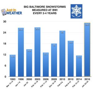
Baltimore history of snowless February(s) and winters when March brought the most snow:
Click here to see more: March Snow After Winter Has Been Slow
Please share your thoughts, best weather pics/video, or just keep in touch via social media
-
Facebook: Justin Berk, Meteorologist
-
Twitter: @JustinWeather
-
Instagram: justinweather
WEATHER WIFE COLLECTION
- Thanks to Shannon (weather wife) for hand picking items ‘she’ wants to wear
- The Yoga Pants have side leg pocket for your phone
- The Hoodie is extra soft and has the important ‘thumb holes’
Part 1: More Snow This Winter Supported By Stats
Part 2: Solar Minimum- Low Sunspots May Mean High Snow Totals This Winter
Part 3: Tropical Systems In East Asia and Atlantic Basin Hint At Winter Storm Tracks
Snowy Winters Following A Hot and Dry September
NOAA Winter Outlook Leaves Room For More Snow With Mild ‘Seasonal Average’ Temperatures
Baltimore Weather At BWI May Not Be As Hot As Reported
Construction at the airport close to the weather station may be added artificial heat. Click here or the image for the details.
Atmospheric Memory Shaped The US East Coast
Atmospheric Memory Of Hurricanes Over Thousands Of Years Shaped The Coast
Maryland Trek Cycle Jerseys From Hill Killer
All proceeds will go to the Maryland Trek 6 total and Just In Power Kids programs
Thank you to our Title Sponsor for Maryland Trek 6
Shining on with Smyth and their contribution, our team has raised over $95,000 for Just In Power Kids to provide free programs for kids in and post cancer treatment.
Just In Power Kids:
Proceeds go to our programs Providing FREE holistic care for kids in cancer treatment and up to 5 years post treatment and caregivers.

Shine On
Proceeds from all sales go to Just In Power Kids. Click the image to shop and show your support.


