Sunday January 5 2020
Even within a warm pattern, we can get snow. This is not just for the mountains or inland suburbs, but there is a chance for some wet snow on Tuesday. The system I have been showing you continues to shift east on the computer guidance. So at least that part of my model error in winter outlook is proving true and there will be more. The snow is likely to be more ambience than impact, but it’s something for snow lovers. FITF! See more below.
Sunday Weather
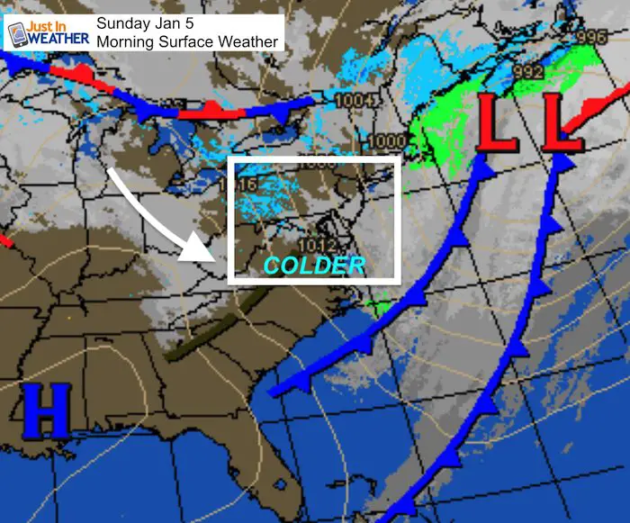
This morning we have colder winds behind the latest cold front, and there will fresh snow for the ski areas of western Maryland, West Virginia, and western PA. The snow burst has led to a large vehicle accident on the Pennsylvania Turnpike this morning. I-76 has a highway detour near Seven Springs between Donegal and New Stanton according to PennDOT’s 511PA.
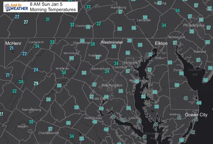
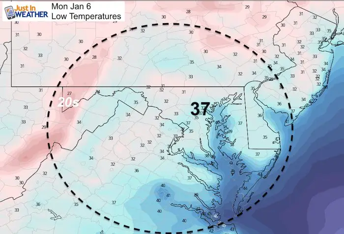
Morning Temperatures
Sunday January 5, 2020 in Baltimore
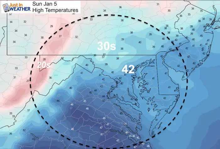
Average High: 42ºF
Record High: 67ºF in 1997
Average Low: 25ºF
Record Low: 1ºF in 1877
*Record Snow 1.8″ in 1980
Sunrise: 7:26 AM
Sunset 4:57 PM
*Daylight = 0:52 longer than yesterday
*Bay Water Temperature = 44ºF at Thomas Pt. Light House
*We have almost caught back to balance out the excessive warmth*
Get Forecasts By Email
Just in case you don’t get all posts on your social media feed, stay up to date with the latest info…
Click here to sign up for email alerts…. Be the first to hear any new weather
Sunday Afternoon
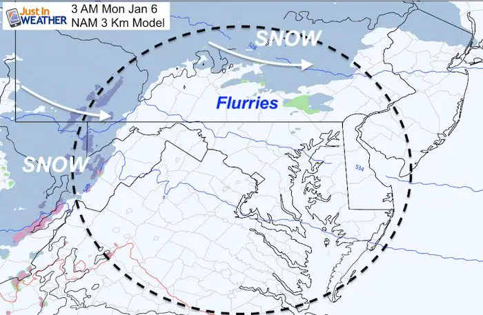
Monday Morning
There will be some more snow in the mountains, with flurries as close as southern PA.
Monday Afternoon
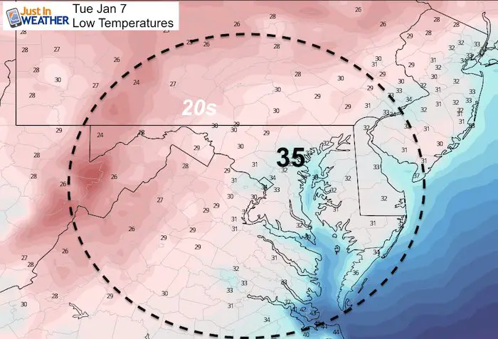
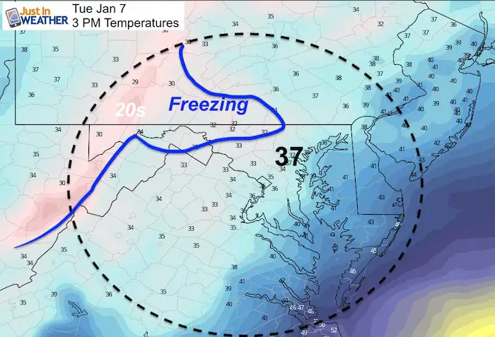
Tuesday
This is the same model that showed the Low Pressure near Pittsburgh just two days ago. Now the track has shifted southeast off of the coast, which brings in the snow chance into Baltimore and Washington. This will be the first snow chance in a few weeks and might be the last for another 10 days. So let’s not get ahead of ourselves… This should be more ambience than impact locally.
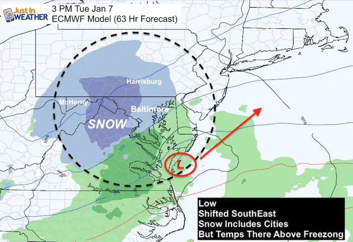
The GFS Model is now agreeing with the snow track (somewhat). This will be daytime event and temps on the ground are too warm for stickage in most local metro areas. It will be more impactful in New England.
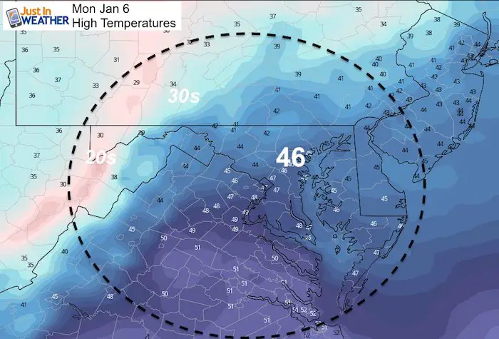
Temperatures
Temps don’t support stickage except for the inland suburbs.
Looking Ahead
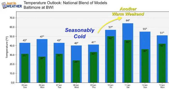
The cold air in this pattern only brings us close to ‘normal’. We will have another warm weekend ahead. But the long rang global pattern will change. I will have more on that in my next report.
Please share your thoughts, best weather pics/video, or just keep in touch via social media
-
Facebook: Justin Berk, Meteorologist
-
Twitter: @JustinWeather
-
Instagram: justinweather

WEATHER WIFE COLLECTION
- Thanks to Shannon (weather wife) for hand picking items ‘she’ wants to wear
- The Yoga Pants have side leg pocket for your phone
- The Hoodie is extra soft and has the important ‘thumb holes’


Part 1: More Snow This Winter Supported By Stats

Part 2: Solar Minimum- Low Sunspots May Mean High Snow Totals This Winter

Part 3: Tropical Systems In East Asia and Atlantic Basin Hint At Winter Storm Tracks


Snowy Winters Following A Hot and Dry September

NOAA Winter Outlook Leaves Room For More Snow With Mild ‘Seasonal Average’ Temperatures


Baltimore Weather At BWI May Not Be As Hot As Reported
Construction at the airport close to the weather station may be added artificial heat. Click here or the image for the details.

Atmospheric Memory Shaped The US East Coast
Atmospheric Memory Of Hurricanes Over Thousands Of Years Shaped The Coast

Was Your County Not Included?
Click this map for more on the regional forecast zones

Maryland Trek Cycle Jerseys From Hill Killer
All proceeds will go to the Maryland Trek 6 total and Just In Power Kids programs

Thank you to our Title Sponsor for Maryland Trek 6
Shining on with Smyth and their contribution, our team has raised over $95,000 for Just In Power Kids to provide free programs for kids in and post cancer treatment.

Just In Power Kids:
Proceeds go to our programs Providing FREE holistic care for kids in cancer treatment and up to 5 years post treatment and caregivers.
![]()
Shine On
Proceeds from all sales go to Just In Power Kids. Click the image to shop and show your support.
