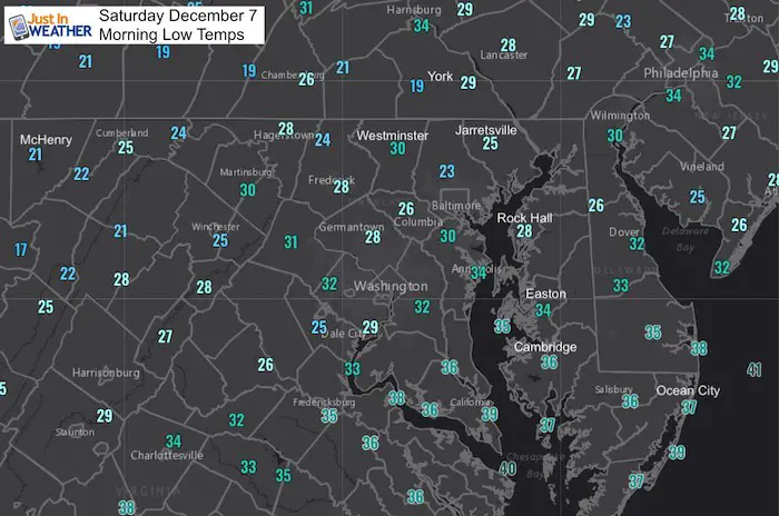
Saturday December 7 2019
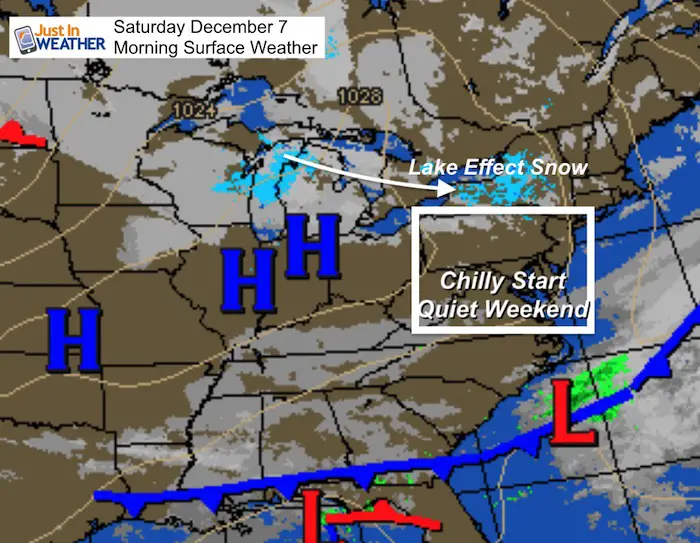
This morning temperatures were very cold, but we are turning the corner this weekend. The weather will be quiet and afternoon temperatures will get back to the seasonal 40s both afternoons. It’s Monday through Wednesday when a strong storm will bring big changes. Also check out the new Weather Wife FITF collection below 🙂
So let’s cut to the chase! There will be a strong storm arriving on Monday with heavy rain and warming us to the 60s. Rain totals will be in the 1 to 2 inch (plus) range across the area.
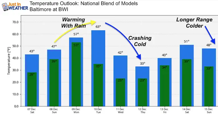
Often in December when we warm up that much, the bottom falls out following the storm. This will happen on Wednesday and the rain may end with some snow. I was hesitant to jump on the models, but feel I have a better handle to explain what this really will mean. The outlook is posted below, but know that the Bay water is still warmer than ‘normal’ and needs to chill before much of central Maryland can get in on any wintry action. Also, the longer range does bring colder air through Christmas.
Saturday Morning Surface Weather
Saturday December 7, 2019 in Baltimore
Average High: 48ºF
Record High: 77ºF in 1998
Average Low: 30ºF
Record Low: 6ºF in 2002
Sunrise: 7:12 AM
Sunset 4:43 PM
*Daylight = 0:56 shorter than yesterday
*Bay Water Temperature = 45ºF at Thomas Pt. Light House (last year was 42ºF)
Get Forecasts By Email
Just in case you don’t get all posts on your social media feed, stay up to date with the latest info…
Click here to sign up for email alerts…. Be the first to hear any new weather
WEATHER WIFE COLLECTION
- Thanks to Shannon (weather wife) for hand picking items ‘she’ wants to wear
- The Yoga Pants have side leg pocket for your phone
- The Hoodie is extra soft and has the important ‘thumb holes’

Jumping Ahead to Monday’s Storm
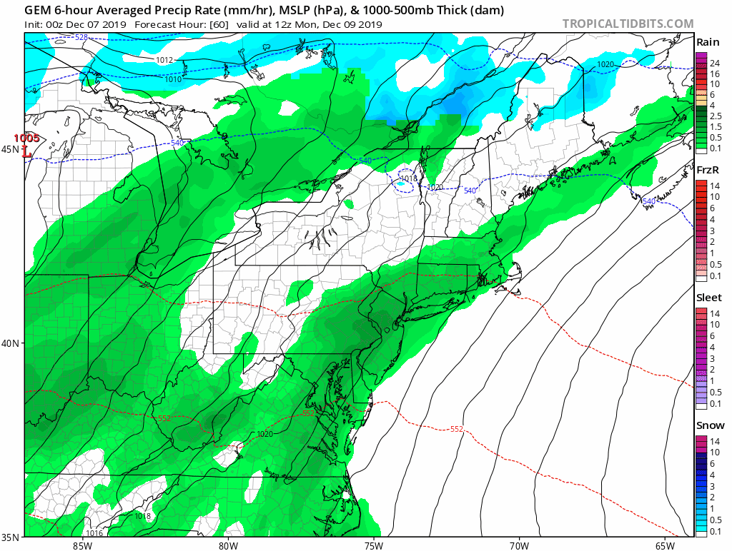
We will be on the warm side of this event, which means rain. It will spread in Monday and last into Tuesday when we could reach the 60s. Then the back edge of the storm will have the colder air catch up and change the last few hours to snow. This is the Canadian GEM Model… That may not show the rain as well, but does highlight and maybe exaggerate the snow on the back edge a little. I’ll explain below….
Closer Look At The Storm
The European Model does show the most likely set up: Cold air will catch up and change the rain to snow Wednesday morning. But I’ve highlighted the 540 DM Thickness (between 100mb and 500mb). This is basically an analysis of where the atmosphere will support pure snow and the freezing line for stickage. As we can see, the snow jumps ahead or east of that line. So we could get snow that melts on the ground for many.
This is where any model showing snowfall will not be accurate blending in the waste of melted flakes. But, we could see snow Wednesday morning.
—> slider


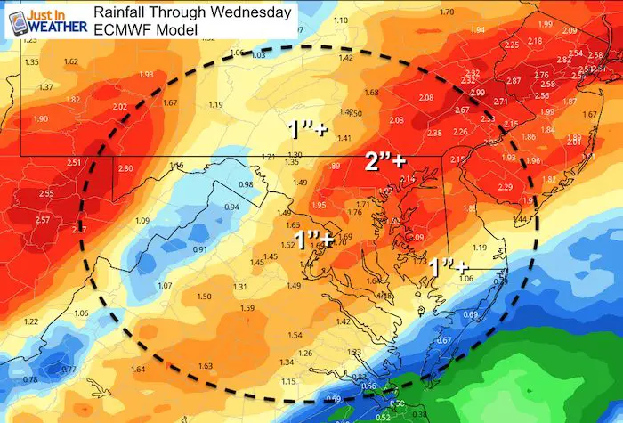
Rain Potential
The European Model projection for rain totals are in the 1 to 2 (plus) inch range
Jet Stream
Here is where the arctic air will be and track. Notice the dip deep in the the south central US. but when it moves our way, it skips north. We will get a taste for a few days, but not the core.
This is what the great Larry Cosgrove calls the Mother Load of cold air into the US. This is NOT the Polar Vortex, but will bring polar air well south. We will warm ahead of it and only get a small taste swinging through Wednesday
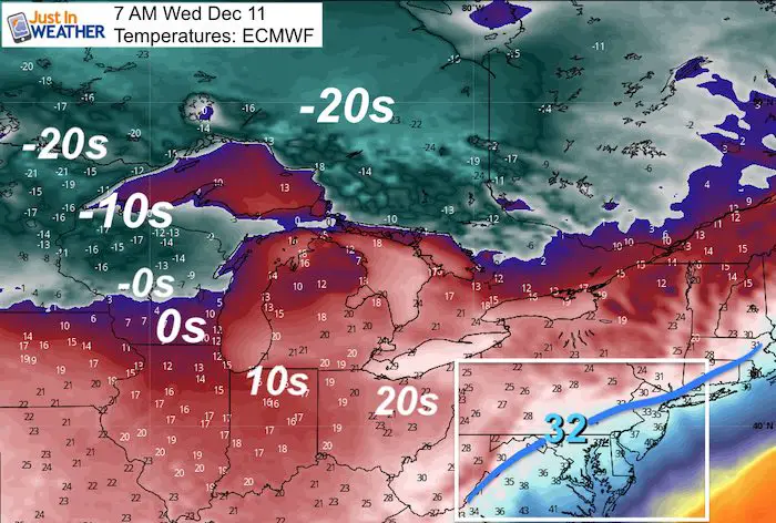
Temperatures Wednesday Morning
Notice the actual readings expected to be well below Zero! The wind chills will be colder. But central Maryland will be on the edge of the freezing line at that time
Temperature Outlook
The jet stream will relax after this arctic push. We may need to watch for another storm to pass through with the warming at the end of next week. Then in the longer range bond this view, we should get into a colder pattern through Christmas. I have Faith in the Flakes! There will be a few chances over the next 3 weeks.
Please share your thoughts, best weather pics/video, or just keep in touch via social media
-
Facebook: Justin Berk, Meteorologist
-
Twitter: @JustinWeather
-
Instagram: justinweather
Winter Outlook Series:
My Call For Snowfall Winter 2019-2020

Part 1: More Snow This Winter Supported By Stats

Part 2: Solar Minimum- Low Sunspots May Mean High Snow Totals This Winter

Part 3: Tropical Systems In East Asia and Atlantic Basin Hint At Winter Storm Tracks


Snowy Winters Following A Hot and Dry September

NOAA Winter Outlook Leaves Room For More Snow With Mild ‘Seasonal Average’ Temperatures


Baltimore Weather At BWI May Not Be As Hot As Reported
Construction at the airport close to the weather station may be added artificial heat. Click here or the image for the details.

Atmospheric Memory Shaped The US East Coast
Atmospheric Memory Of Hurricanes Over Thousands Of Years Shaped The Coast

Was Your County Not Included?
Click this map for more on the regional forecast zones

Maryland Trek Cycle Jerseys From Hill Killer
All proceeds will go to the Maryland Trek 6 total and Just In Power Kids programs

Thank you to our Title Sponsor for Maryland Trek 6
Shining on with Smyth and their contribution, our team has raised over $95,000 for Just In Power Kids to provide free programs for kids in and post cancer treatment.

Just In Power Kids:
Proceeds go to our programs Providing FREE holistic care for kids in cancer treatment and up to 5 years post treatment and caregivers.
![]()
Shine On
Proceeds from all sales go to Just In Power Kids. Click the image to shop and show your support.
