Saturday November 30 2019
It is Small Business Saturday and working with a local Maryland business we have a special on all FITF gear. On this last day of November the map is starting to look a lot more like winter. For posterity I should all mention this is the last day of the Atlantic hurricane season. An ice storm will hit western Maryland and some glazing in nearby northern suburbs Sunday morning. A much larger snow storm in metro New York and New England. Some colder air and snow showers could reach back to Maryland on Monday.
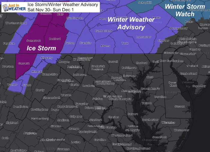
Ice Storm Warning and Winter Weather Advisory
- Western Maryland: Ice begins tonight in Cumberland, Frostburg, and McHenry.
- Southern PA: Icing before sunrise until 10 AM Sunday
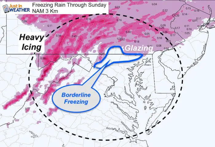
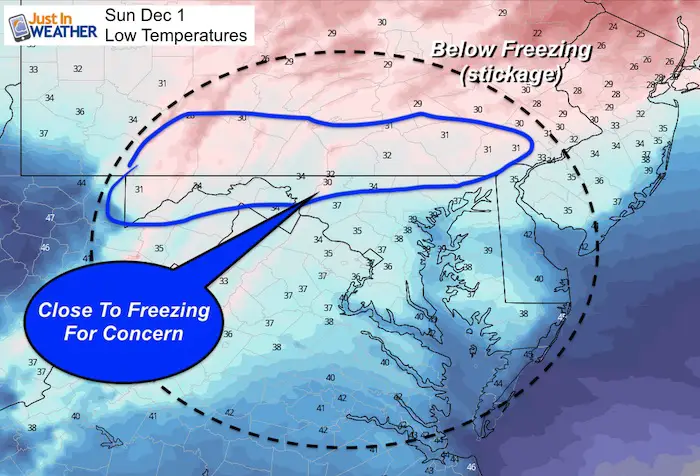
- Northern MD: Temps will be borderline freezing, so there could be some icy pockets at daybreak
Ice Accumulation Potential
See the simulation timeline and full forecast below.
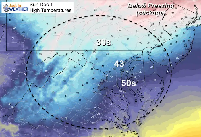
Note: Sunday will bring moderate to heavy rain in Maryland. The Ravens game in Baltimore will be soggy with temps in the lower 40s.
Small Business Saturday Celebration: 20% OFF ALL Collections
I work with Maryland Print House in Carroll County to produce these items. Click here and use the Code at checkout

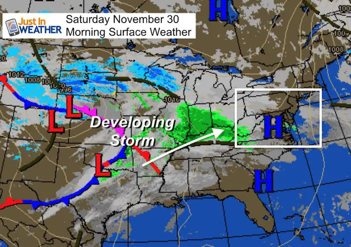
Saturday Morning Weather
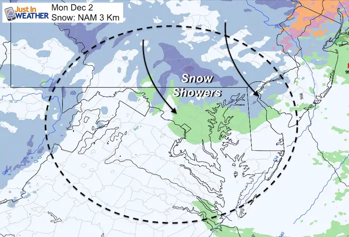
The developing storm will keep most of the colder air to our west and north. In addition to the cold air at the start, we will get in on some snow showers behind it on Monday.
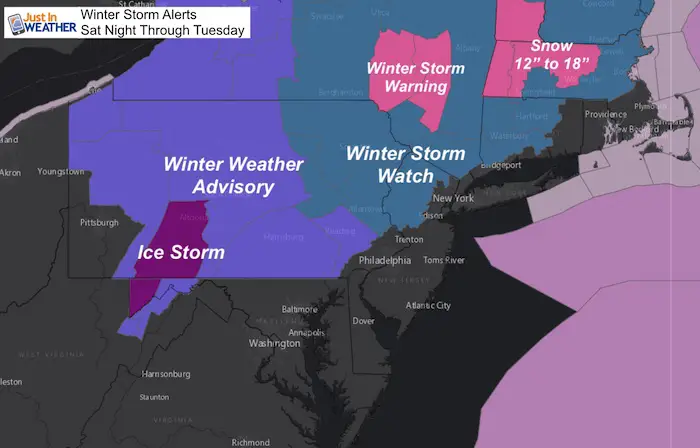
Travel Problems Sunday – Tuesday
- An impact winter storm will bring ice and snow to the Poconos and metro NYC.
- Heavy snow will hit the Catskills, Hudson Valley, and New England. Some spots could get well over 12 inches of snow.
Local Weather Stats:
Saturday November 30, 2019 in Baltimore
Average High: 51ºF
Record High: 74ºF in 193
Average Low: 32ºF
Record Low: 12ºF in 1929
- Record Snow = 8.4″ 1967
Sunrise: 7:05 AM
Sunset 4:43 PM
*Daylight = 1:17 shorter than yesterday
*Bay Water Temperature = 48ºF at Thomas Pt. Light House
Get Forecasts By Email
Just in case you don’t get all posts on your social media feed, stay up to date with the latest info…
Click here to sign up for email alerts…. Be the first to hear any new weather
Thank you to our Title Sponsor for Maryland Trek 6
Shining on with Smyth and their contribution, our team has raised over $95,000 for Just In Power Kids to provide free programs for kids in and post cancer treatment.

Today will be quiet and cool. The issue will begin after 7 PM in the mountains in western Maryland
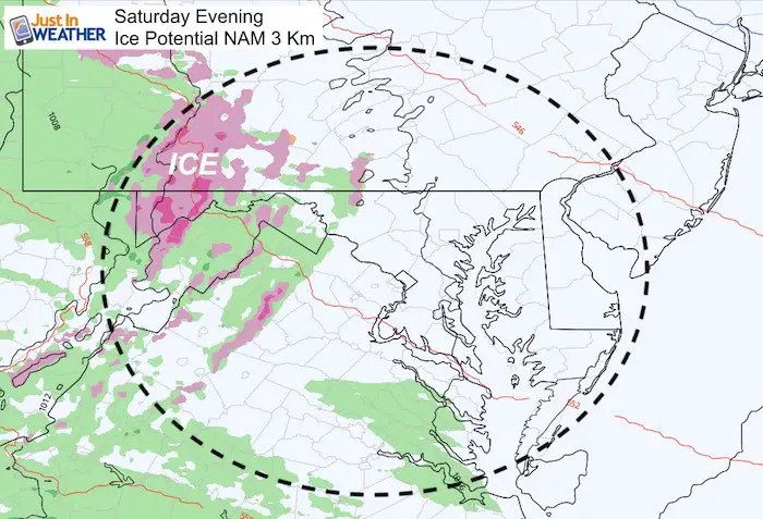
Sunday Ice Simulation —> slider


Temperatures
Storm Animation
Monday Snow Showers
The colder air behind the storm should bring some flakes back into southern PA and Maryland. If there is any stickage, it would be in the northern Zones.
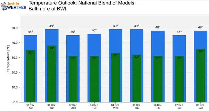
Temperature Outlook
Remaining cooler than average for the start of December. The air mass may end up colder than shown next week as this model is weighted with climatology farther out in time.
Please share your thoughts, best weather pics/video, or just keep in touch via social media
-
Facebook: Justin Berk, Meteorologist
-
Twitter: @JustinWeather
-
Instagram: justinweather
Winter Outlook Series:
My Call For Snowfall Winter 2019-2020

Part 1: More Snow This Winter Supported By Stats

Part 2: Solar Minimum- Low Sunspots May Mean High Snow Totals This Winter

Part 3: Tropical Systems In East Asia and Atlantic Basin Hint At Winter Storm Tracks


Snowy Winters Following A Hot and Dry September

NOAA Winter Outlook Leaves Room For More Snow With Mild ‘Seasonal Average’ Temperatures


Baltimore Weather At BWI May Not Be As Hot As Reported
Construction at the airport close to the weather station may be added artificial heat. Click here or the image for the details.

Atmospheric Memory Shaped The US East Coast
Atmospheric Memory Of Hurricanes Over Thousands Of Years Shaped The Coast

Was Your County Not Included?
Click this map for more on the regional forecast zones

Maryland Trek Cycle Jerseys From Hill Killer
All proceeds will go to the Maryland Trek 6 total and Just In Power Kids programs

Just In Power Kids:
Proceeds go to our programs Providing FREE holistic care for kids in cancer treatment and up to 5 years post treatment and caregivers.
![]()
Shine On
Proceeds from all sales go to Just In Power Kids. Click the image to shop and show your support.
