Saturday October 19 2019
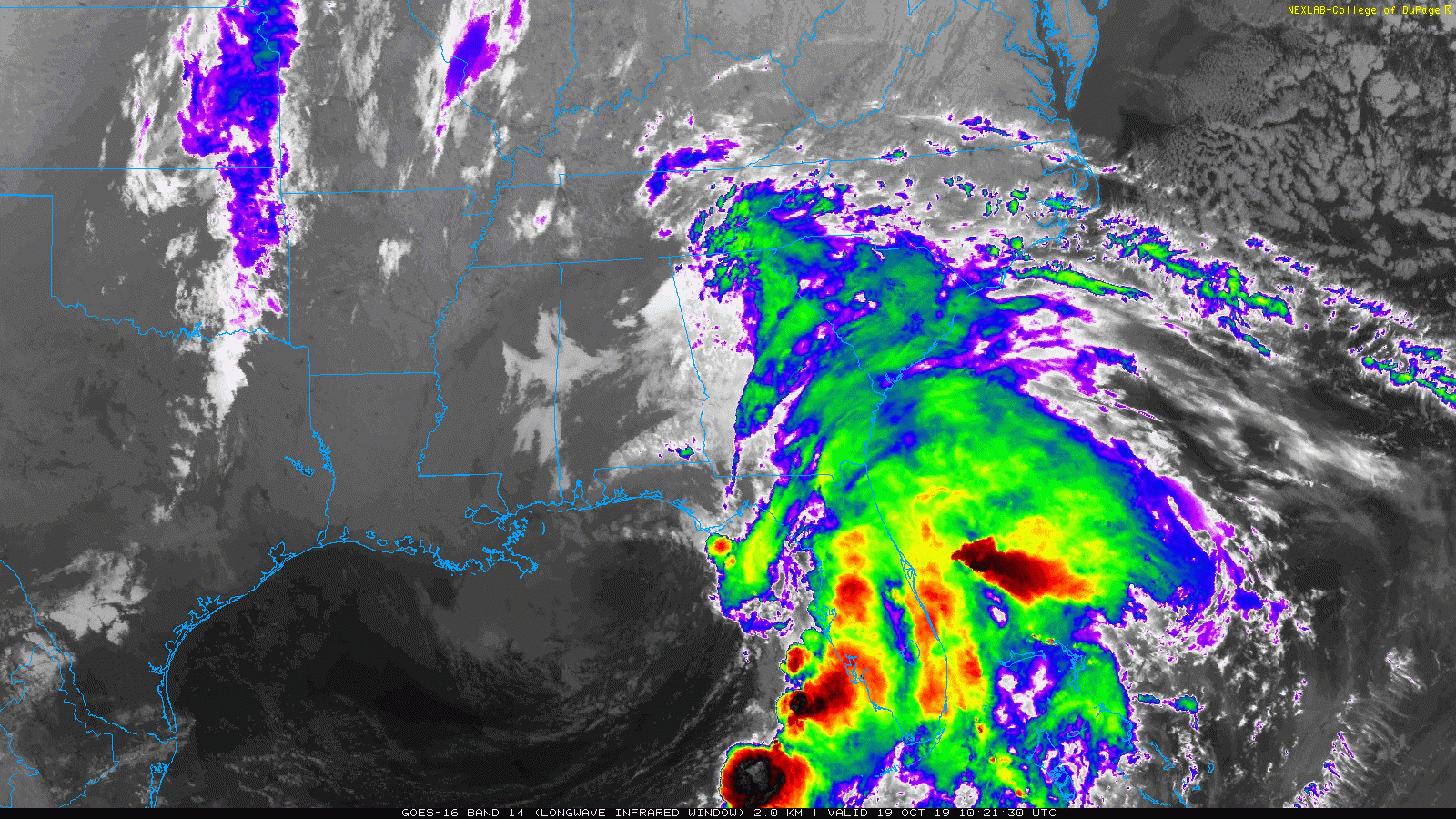
This morning brought some frost to parts of our region and tomorrow morning should bring rain for most of us. Tropical Storm Nestor formed in the Gulf of Mexico yesterday and is quickly moving onshore in the Florida Panhandle. Winds are 50 mph, but it is not well organize, as all of the action has been to the east of the Low, but strong enough to produce damaging tornados in Tampa overnight.
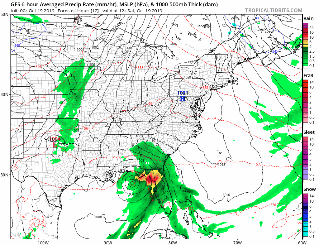
I have three different computer models to compare below. Often as we enter a new season, there are new pattern challenges in forecasting. Spotting them now may help with the important winter storms in a few months, and I want to share what I see with you.
Rain will develop during Sunday morning, and the heaviest is expected in southern Maryland. But there is a big split in how much impact will be felt in northern Maryland and southern PA. The difference shown is under 0.25″ to over 2″ and can really change how the day plays out there.

Tropical Storm Nestor Track
The official National Hurricane Center stats and track are below. This is holding with what I showed yesterday, but the big question is how far north the rain will spread. See more below
Tropical Storm Nestor Satellite Loop
SUMMARY OF 800 AM EDT...1200 UTC...INFORMATION
----------------------------------------------
LOCATION...29.5N 86.8W
ABOUT 80 MI...125 KM WSW OF PANAMA CITY FLORIDA
ABOUT 110 MI...175 KM W OF APALACHICOLA FLORIDA
MAXIMUM SUSTAINED WINDS...50 MPH...85 KM/H
PRESENT MOVEMENT...NE OR 45 DEGREES AT 17 MPH...28 KM/H
MINIMUM CENTRAL PRESSURE...996 MB...29.41 INCHES

This storm will be downgraded to a post tropical cyclone later today after landfall.

Sunday Rain Forecast
The ECWMF Model is the most reliable and has been consistent with the track of the rain Sunday. This shows a sharp cutoff of the rain north and west of Baltimore. However, the NAM 3 Km is a high resolution model generated more frequently, and shows heavier rain pushing on the north side of our area. This model has a history of overdoing some events, but this is worth mentioning for the impact of a second band of heavy rain.
Radar Simulation ECMWF Model —> slider
[metaslider id=80581]
Rainfall Potential

Radar Simulation NAM 3 Km Model —> slider
[metaslider id=80596]
Rainfall Potential
This shows a trough on the north side of the storm to focus a second band of heavy rain (over 1 inch) across central and northern Maryland into south PA. 
Storm Animation: GFS Model
This model shows a similar rain path as the ECMWF. I am showing this to highlight the next wave of rain for all of our region on Tuesday.
Get Forecasts By Email
Just in case you don’t get all posts on your social media feed, stay up to date with the latest info…
Click here to sign up for email alerts…. Be the first to hear any new weather
Thank you to our Title Sponsor for Maryland Trek 6
Shining on with Smyth and their contribution, our team has raised over $95,000 for Just In Power Kids to provide free programs for kids in and post cancer treatment.

Please share your thoughts, best weather pics/video, or just keep in touch via social media
-
Facebook: Justin Berk, Meteorologist
-
Twitter: @JustinWeather
-
Instagram: justinweather
ALL FITF Apparel Available


New Colors
We are giving 10% of each sale to Just In Power Kids: Providing FREE holistic care to pediatric oncology patients and FREE healthy meals to local hospitals.

October is Breast Cancer Awareness Month
Love Maryland Shirts and Hoodies
This shirt was designed by my ‘bonus’ daughter Jaiden. The hoodie has been the biggest hit, so our promotion is back this year. Join us to support the cause and show off your Love of Maryland
|
||
|
Show your love for Maryland and make this 15 year old artist and her mom extra proud
|


Also See:
NOAA Winter Outlook Leaves Room For More Snow With Mild ‘Seasonal Average’ Temperatures

Moderate Drought For Half of Maryland and Virginia: Drought Monitor

Many areas inland from the cities should drop into the 30s by tomorrow morning. This could do it. See the look at when we normally expect the first frost in this link.

Snowy Winters Following A Hot and Dry September

Baltimore Weather At BWI May Not Be As Hot As Reported
Construction at the airport close to the weather station may be added artificial heat. Click here or the image for the details.

Other Links:
Atmospheric Memory Shaped The US East Coast
Atmospheric Memory Of Hurricanes Over Thousands Of Years Shaped The Coast

Was Your County Not Included?
Click this map for more on the regional forecast zones

Maryland Trek Cycle Jerseys From Hill Killer
All proceeds will go to the Maryland Trek 6 total and Just In Power Kids programs

Just In Power Kids:
Proceeds go to our programs Providing FREE holistic care for kids in cancer treatment and up to 5 years post treatment and caregivers.
![]()
Shine On
Proceeds from all sales go to Just In Power Kids. Click the image to shop and show your support.
