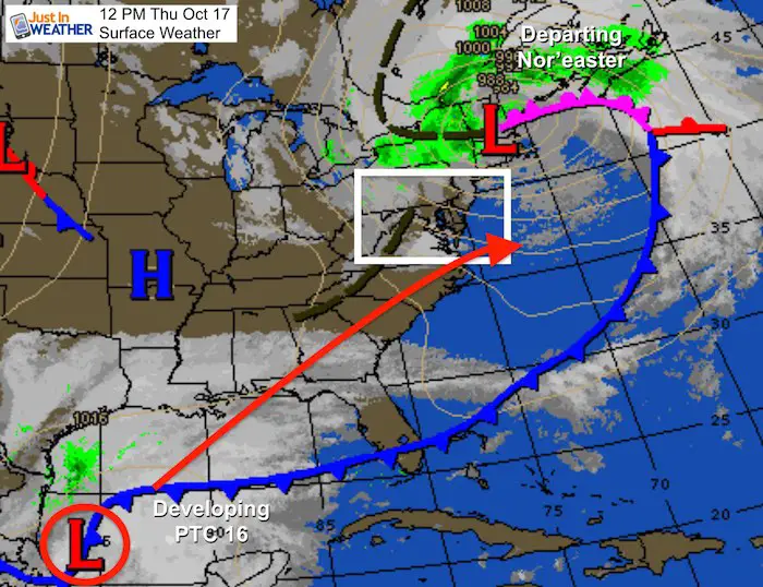
Thursday October 17 2019
The wind machine in place today is from record Low Pressure in New England. That’s the storm that brought us rain yesterday and pulling in gusts to 50 mph today. The next system is forming in the southwest Gulf of Mexico and just identified as Potential Tropical Cyclone 16 from the National Hurricane Center. It is likely to get a name by tonight as it continues to organize.
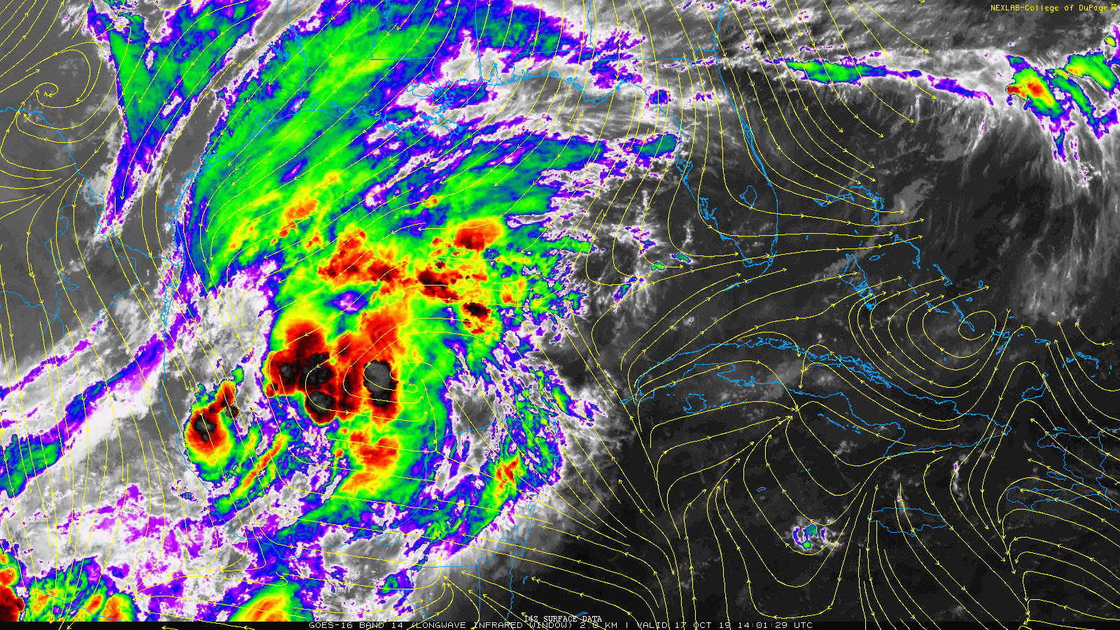
Satellite Loop
The wind flow streamlines have been overlaid on this image. The circulation is in the lower left corner…
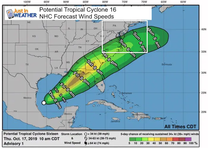
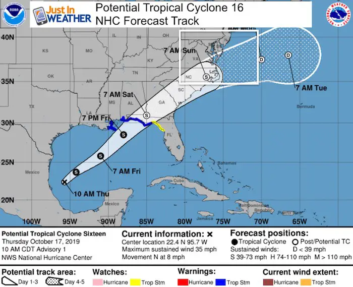
Further development is expected. Winds are currently 35 mph, but within a day it should bump over 40 mph and get named Nestor. Warnings are already up for parts of coastal Louisiana to Florida. The forecast track takes it into North Carolina by Sunday morning.
Conditions from NWS
SUMMARY OF 1000 AM CDT...1500 UTC...INFORMATION
-----------------------------------------------
LOCATION...22.4N 95.7W
ABOUT 140 MI...225 KM E OF TAMPICO MEXICO
ABOUT 620 MI...995 KM SW OF THE MOUTH OF THE MISSISSIPPI RIVER
MAXIMUM SUSTAINED WINDS...35 MPH...55 KM/H
PRESENT MOVEMENT...N OR 355 DEGREES AT 8 MPH...13 KM/H
MINIMUM CENTRAL PRESSURE...1007 MB...29.74 INCHES
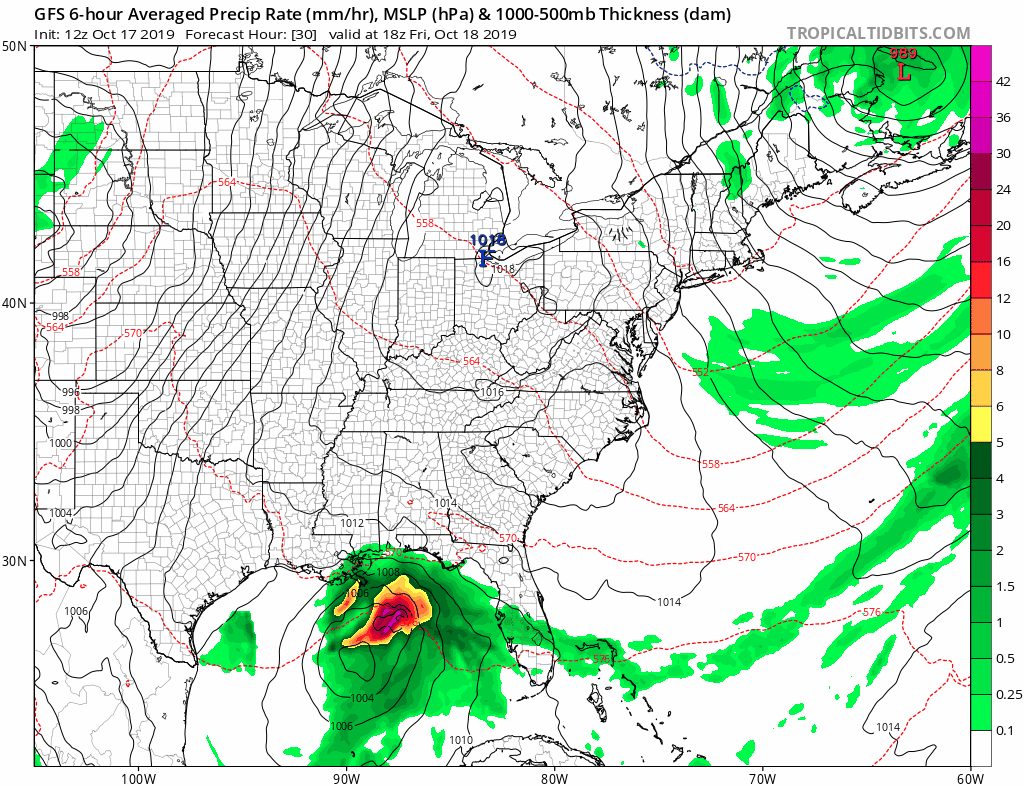
European Model Forecast —> slider
The Low Pressure will track inland this weekend and pass off of the North Carolina/Virginia coast Sunday. This will be close enough to brig some rain into Maryland and tropical storm winds especially south of the Bay Bridge.
[metaslider id=80532]
Forecast Animation GFS Model
While I think the model is not giving the potential rain on Sunday justice, there will be another rain event to follow on Tuesday
Wind Forecast Ocer 40 mph
The best chance locally for this to occur will be Sunday morning and in southern Maryland and the southern half of Delmarva
National Hurricane Center Forecasts
It’s likely that this will be hybrid storm and post tropical cyclone when it reaches the Mid Atlantic Sunday.
Note: The thing to watch is is there will be a north bump of verification compared to the modeling. We have seen that with prior systems.
I will have another update tonight.
WATCHES AND WARNINGS
--------------------
CHANGES WITH THIS ADVISORY:

A Tropical Storm Warning is in effect from the Mississippi/Alabama
border to the Ochlockonee River, Florida.

A Tropical Storm Warning is in effect from Grand Isle, Louisiana to
the Mouth of the Pearl River.

A Tropical Storm Watch is in effect east of the Ochlockonee River to
Yankeetown, Florida.

A Storm Surge Watch is in effect from Indian Pass, Florida, to
Clearwater, Florida.

SUMMARY OF WATCHES AND WARNINGS IN EFFECT:

A Tropical Storm Warning is in effect for...
* Mississippi/Alabama border to the Ochlockonee River, Florida
* Grand Isle, Louisiana to the Mouth of the Pearl River

A Tropical Storm Watch is in effect for...
* East of the Ochlockonee River to Yankeetown, Florida

A Storm Surge Watch is in effect for...
* Indian Pass to Clearwater, Florida
Get Forecasts By Email
Just in case you don’t get all posts on your social media feed, stay up to date with the latest info…
Click here to sign up for email alerts…. Be the first to hear any new weather
Thank you to our Title Sponsor for Maryland Trek 6
Shining on with Smyth and their contribution, our team has raised over $95,000 for Just In Power Kids to provide free programs for kids in and post cancer treatment.

Please share your thoughts, best weather pics/video, or just keep in touch via social media
-
Facebook: Justin Berk, Meteorologist
-
Twitter: @JustinWeather
-
Instagram: justinweather
October is Breast Cancer Awareness Month
Love Maryland Shirts and Hoodies
This shirt was designed by my ‘bonus’ daughter Jaiden. The hoodie has been the biggest hit, so our promotion is back this year. Join us to support the cause and show off your Love of Maryland
|
||
|
Show your love for Maryland and make this 15 year old artist and her mom extra proud
|


Also See:
Moderate Drought For Half of Maryland and Virginia: Drought Monitor

Many areas inland from the cities should drop into the 30s by tomorrow morning. This could do it. See the look at when we normally expect the first frost in this link.

Snowy Winters Following A Hot and Dry September

Baltimore Weather At BWI May Not Be As Hot As Reported
Construction at the airport close to the weather station may be added artificial heat. Click here or the image for the details.

Other Links:
Atmospheric Memory Shaped The US East Coast
Atmospheric Memory Of Hurricanes Over Thousands Of Years Shaped The Coast

Was Your County Not Included?
Click this map for more on the regional forecast zones

Maryland Trek Cycle Jerseys From Hill Killer
All proceeds will go to the Maryland Trek 6 total and Just In Power Kids programs

Just In Power Kids:
Proceeds go to our programs Providing FREE holistic care for kids in cancer treatment and up to 5 years post treatment and caregivers.
![]()
Shine On
Proceeds from all sales go to Just In Power Kids. Click the image to shop and show your support.
