Wednesday September 4 2019
Today may be our last day with summer heat, at least for a while. A cold front will arrive by this evening to spark local storms and help steer Hurricane Dorian away from Maryland. But the track of the hurricane may bring it onshore in North Carolina and send some impacts into Maryland. This post will cover our local weather and the hurricane forecast up the coast.
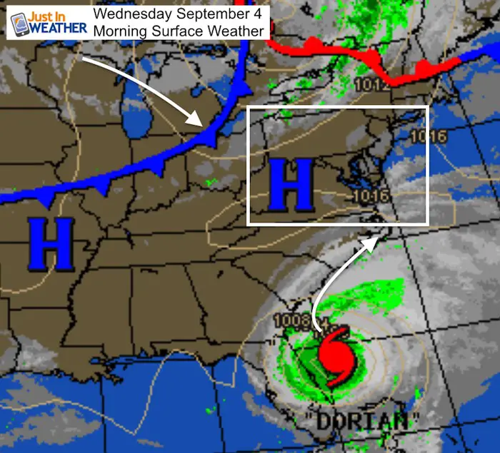
Wednesday Morning Surface Weather
Headlines:
- Local showers and storms today after 4 PM
- Temps today near 90ºF, Thursday and Friday in the 70s
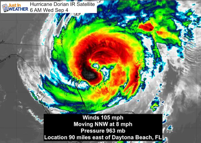
- Hurricane Dorian is a Cat 2 with 105 mph winds
- Hurricane force winds reach 60 miles from the center
- Tropical Storm force winds reach 175 miles from the center
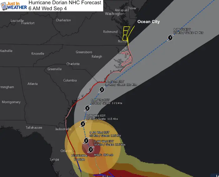
- Track is close to Charleston, SC, may make landfall in NC
- Impact for Ocean City on Friday; Wind Gusts to 55 mph
Hurricane Dorian IR Satellite
Hurricane Dorian winds are lower, but the size is larger. This was expected and the impact zone spreads well up the coast.
Hurricane Dorian IR Satellite
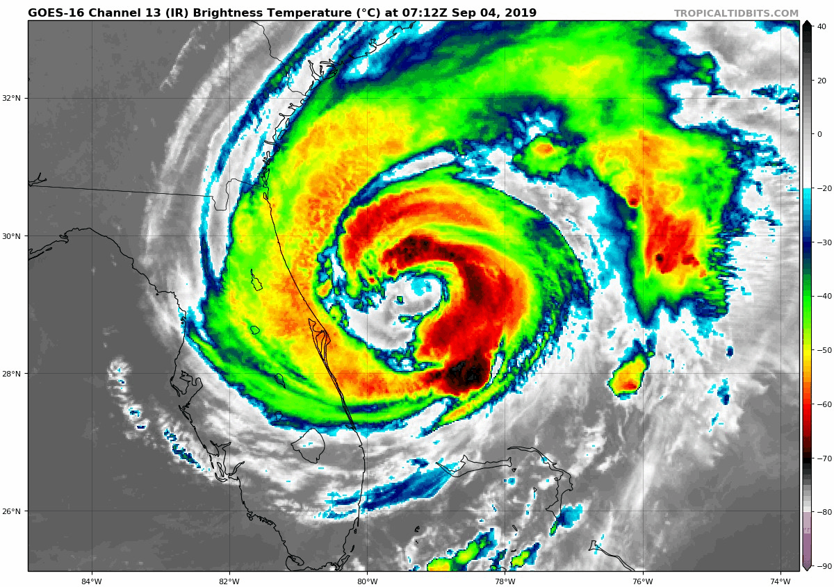
SUMMARY OF 500 AM EDT...0900 UTC...INFORMATION
----------------------------------------------
LOCATION...29.2N 79.5W
ABOUT 90 MI...145 KM E OF DAYTONA BEACH FLORIDA
MAXIMUM SUSTAINED WINDS...105 MPH...165 KM/H
Hurricane Dorian IR Satellite...13 KM/H
MINIMUM CENTRAL PRESSURE...963 MB...28.44 INCHES


Back To Local Weather Today
High Temperatures Today

Radar Simulation —> slider
[metaslider id=79590]
High Temperatures Thursday

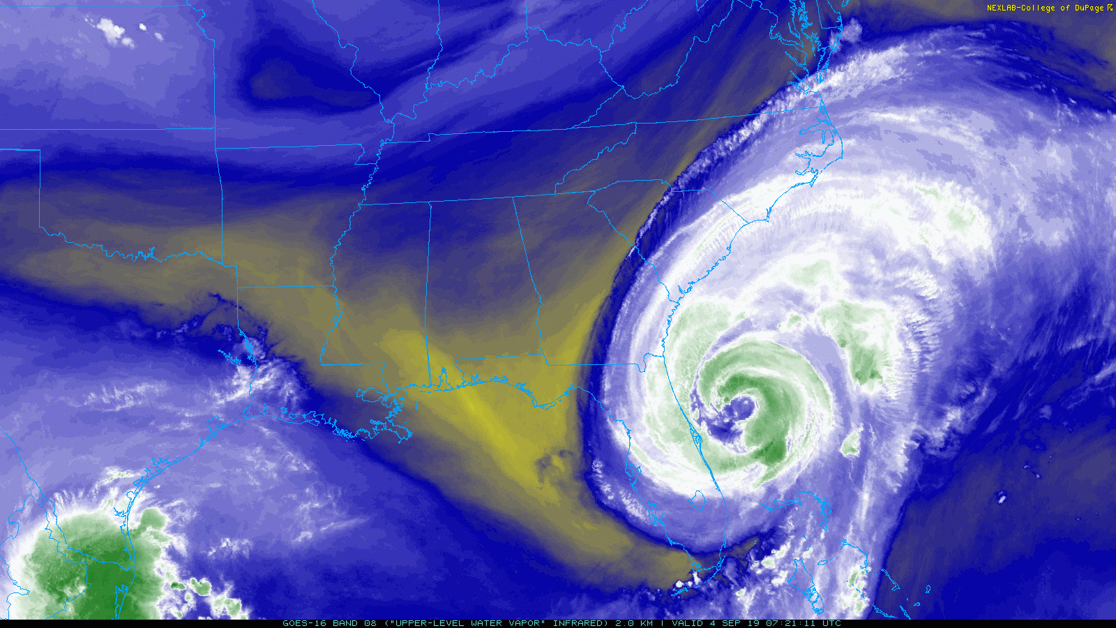
Water Vapor Satellite Loop
A hint of our cold front can be seen at the top of the image. Hurricane Dorian can be seen stretching up north farther. The clouds will reach Ocean City, MD this morning.
National Hurricane Canter Forecast Track
Also see: Atmospheric Memory Shaped The US Coast
Model Forecasts: European ECMWF and GFS In Agreement
Rain showers from the outer bands could reach northern Delmarva and central Maryland Friday afternoon. Bands of heavy rain with tropical storm force winds for the beaches.


Local Impact
- The slower movement has delayed this until later on Friday.
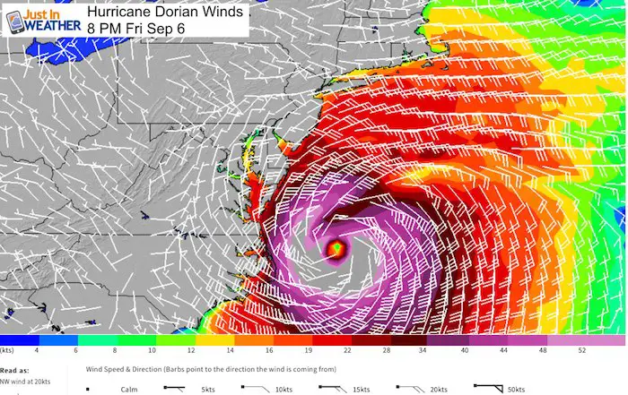
- Hurricane Dorian should move away from North Carolina, but make its closest pass to Ocean City, MD on Friday evening
- Winds: Initially it will push from the south, but change to the north as the storm gets closer. This will help lower water out of the Bay, but hammer beaches.
- Tropical Storm winds with gusts to 55 mph for Ocean City
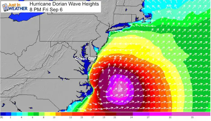
Wave Heights Friday Night
Local Warnings and Watches
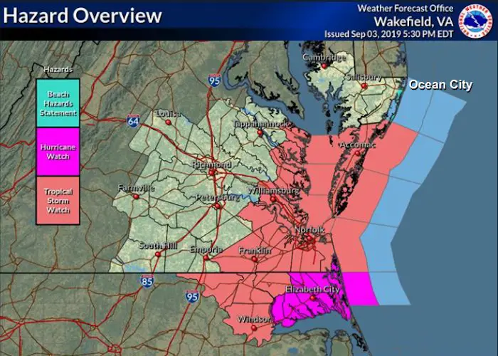
SUMMARY OF WATCHES AND WARNINGS IN EFFECT:

A Storm Surge Warning is in effect for...
* Sebastian Inlet FL to Surf City NC

A Storm Surge Watch is in effect for...
* North of Surf City NC to Poquoson VA, including Hampton Roads
* Pamlico and Albemarle Sounds
* Neuse and Pamlico Rivers

A Hurricane Warning is in effect for...
* Volusia/Brevard County FL line to Ponte Vedra Beach FL
* North of Savannah River to Surf City NC

A Hurricane Watch is in effect for...
* North of Ponte Vedra Beach FL to Savannah River
* North of Surf City NC to the North Carolina/Virginia border
* Albemarle and Pamlico Sounds

A Tropical Storm Warning is in effect for...
* Sebastian Inlet FL to the Volusia/Brevard County FL line
* North of Ponte Vedra Beach FL to Savannah River

A Tropical Storm Watch is in effect for...
* The North Carolina/Virginia border to Chincoteague VA
* Chesapeake Bay from Smith Point southward
Keep In Touch Every Day
Just in case you don’t get all posts on your social media feed, stay up to date with the latest info…
Click here to sign up for email alerts…. Be the first to hear any new weather
Thank you to our Title Sponsor for Maryland Trek 6
Shining on with Smyth and their contribution, our team has raised over $95,000 for Just In Power Kids to provide free programs for kids in and post cancer treatment.

Please share your thoughts, best weather pics/video, or just keep in touch via social media
-
Facebook: Justin Berk, Meteorologist
-
Twitter: @JustinWeather
-
Instagram: justinweather
Maryland Trek Cycle Jerseys From Hill Killer
All proceeds will go to the Maryland Trek 6 total and Just In Power Kids programs

Just In Power Kids:
Proceeds go to our programs Providing FREE holistic care for kids in cancer treatment and up to 5 years post treatment and caregivers.
![]()
Shine On
Proceeds from all sales go to Just In Power Kids. Click the image to shop and show your support.

Love Maryland Shirts and Hoodies
This shirt was designed by my ‘bonus’ daughter Jaiden. The hoodie has been the biggest hit, so our promotion has been extended until the end of this week.
|
||
|
Show your love for Maryland and make this 14 year old artist and her mom extra proud
|


Related Links:
Was Your County Not Included?
Click this map for more on the regional forecast zones
