Tuesday Evening September 3 2019
Hurricane Dorian may have have lower wind speeds, but the size is growing larger. The forward speed is increasing has it heads slower to the US coast and plans to ride along the coast to North Carolina. This storm will impact a large area all the way up to Ocean City, Maryland. But how much of an impact. Also, will there be any impact up the Chesapeake Bay?
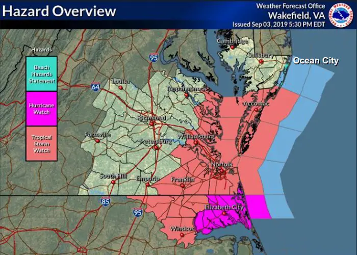
Hurricane Dorian Warnings and Watches
Hurricane Warnings now reach Elizabeth City, North Carolina. This includes all of the Outer Banks (OBX). Tropical Storm Watch up to the Virginia and Maryland border. Beach Hazzard and possible tropical force winds for Ocean City, MD. See the waves and wind forecast including the Bay below.
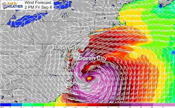
Forecast Wind and Waves
Earlier this evening I described the typical east coast storm tracks that helped shape and follow the coastline. Also why most miss Maryland. This storm should miss as well, but will be close enough to send some water ahead of it. The outer bands will arrive into parts of the state Friday. The good news is that may surge initially, is likely to pull out out as the strongest part passes Friday. More on the local waves and wind forecast below.
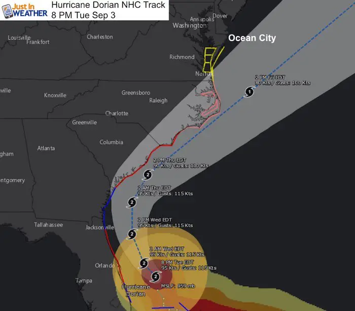
Hurricane Dorian Stats at 8 PM
- Winds 110 mph
- Pressure 959 mb
- Hurricane Force winds reach 60 mph from the center
- Tropical Storm Force Winds reach 175 miles away from the center. This area will continue to expand.
- Center is 110 miles east of Cape Canaveral, Florida
- Movement NW at 6 mph
Hurricane Dorian IR Satellite Loop
The movement to the Northwest can be seen here
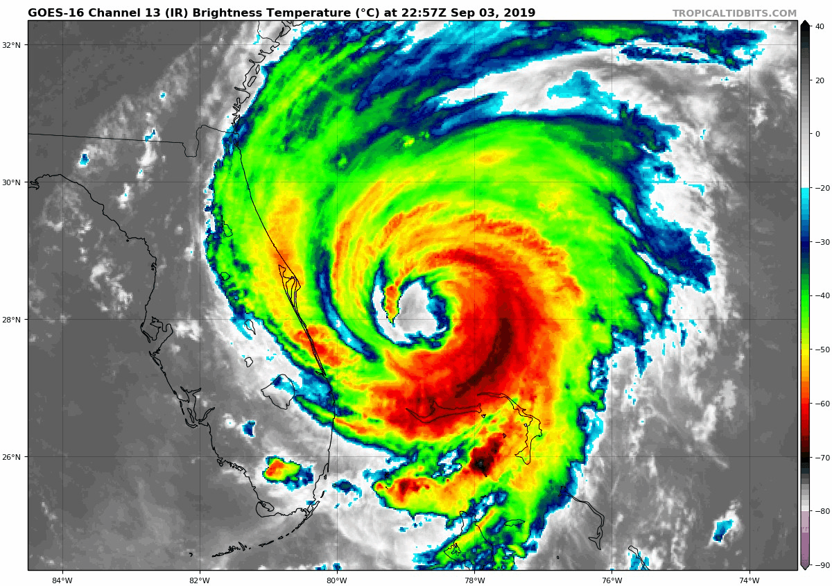
As shown in my earlier report, this strongest side of the hurricane is over the ocean. The weaker side is facing land, but there is still tremendous Beach erosion and dangerous outer bands swinging across Florida.

Hurricane Dorian NHC Forecast
The new speed and track takes this off of Cape Hatteras mid day Friday. That will be the closest approach to Ocean City.
Waves Forecast —> slider
The storm will pull away Friday afternoon, but that is when the strongest waves will last… into Friday night. Saturday will improve a lot.
[metaslider id=79563]
Wind Forecast –> slider
This includes the Chesapeake Bay. This storm will grow larger in size and push water far out ahead of it. If there is to be some surge up the Bay, it will arrive Thursday. Then drain out Friday. See my notes below…
[metaslider id=79549]
Watch the south winds Wednesday into Thursday, then turn east. Water rise will be from the fetch from the south and limiting the low tide from exiting out into the ocean. Then the winds turn to the east, sloshing water to the west side of the bay.
Thursday: Annapolis and the western shore may get flooding
Friday: Winds shift from the north and get stronger as the storm passes off Cape Hatteras. This will pull water south, which will drain out of the Bay, but could flood southern islands first.
I will post an update Wednesday morning, then new waves and wind forecast during the day to sleep you up on any changes.
SUMMARY OF WATCHES AND WARNINGS IN EFFECT:

A Storm Surge Warning is in effect for...
* Jupiter Inlet FL to Surf City NC

A Storm Surge Watch is in effect for...
* North of Surf City NC to Duck NC
* Pamlico and Albemarle Sounds
* Neuse and Pamlico Rivers

A Hurricane Warning is in effect for...
* Sebastian Inlet FL to Ponte Vedra Beach FL
* North of Savannah River to Surf City NC

A Hurricane Watch is in effect for...
* North of Ponte Vedra Beach FL to Savannah River
* North of Surf City NC to the North Carolina/Virginia border
* Albemarle and Pamlico Sounds

A Tropical Storm Warning is in effect for...
* Grand Bahama and the Abacos Islands in the northwestern Bahamas
* North of Ponte Vedra Beach FL to Savannah River
* Jupiter Inlet FL to Sebastian Inlet FL

A Tropical Storm Watch is in effect for...
* The North Carolina/Virginia border to Chincoteague VA
* Chesapeake Bay from Smith Point southward
Keep In Touch Every Day
Just in case you don’t get all posts on your social media feed, stay up to date with the latest info…
Click here to sign up for email alerts…. Be the first to hear any new weather
Thank you to our Title Sponsor for Maryland Trek 6
Shining on with Smyth and their contribution, our team has raised over $95,000 for Just In Power Kids to provide free programs for kids in and post cancer treatment.

Please share your thoughts, best weather pics/video, or just keep in touch via social media
-
Facebook: Justin Berk, Meteorologist
-
Twitter: @JustinWeather
-
Instagram: justinweather
Maryland Trek Cycle Jerseys From Hill Killer
All proceeds will go to the Maryland Trek 6 total and Just In Power Kids programs

Just In Power Kids:
Proceeds go to our programs Providing FREE holistic care for kids in cancer treatment and up to 5 years post treatment and caregivers.
![]()
Shine On
Proceeds from all sales go to Just In Power Kids. Click the image to shop and show your support.

Love Maryland Shirts and Hoodies
This shirt was designed by my ‘bonus’ daughter Jaiden. The hoodie has been the biggest hit, so our promotion has been extended until the end of this week.
|
||
|
Show your love for Maryland and make this 14 year old artist and her mom extra proud
|


Related Links:
Was Your County Not Included?
Click this map for more on the regional forecast zones
