Tuesday September 3 2019
Today is the first day of school for public systems in Maryland, so I need to start with local weather. Also: PLEASE slow down and stop for bus pick ups! We will have two warm days, then two cool days to end the week as Hurricane Dorian passes south off of the coast. There will be some impact in Maryland with both higher water and outer rain bands. The wind speed of Dorian is down to Category 3, but the size is larger. So while the storm is stalled, it will move north today. More on that and what it could mean for us down below.
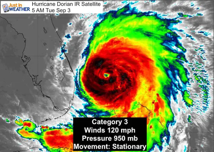
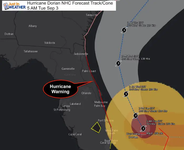
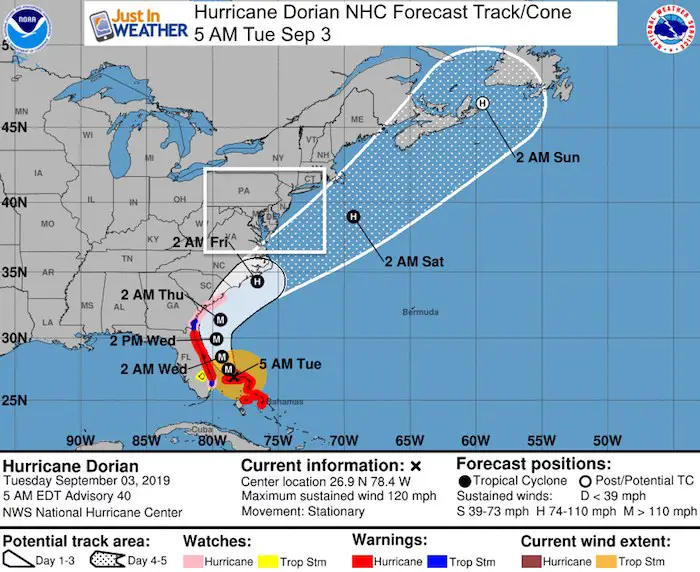
Hurricane Dorian Stats at 5 AM
- Hurricane Force Winds reach 45 mph from the center
- Tropical Storm Force Winds reach 150 miles away. This area will expand.
- Center is 105 miles east of West Palm Beach Florida
- Wind gust to 61 mph on Juno Beach Pier, FL
- Movement now Stationary
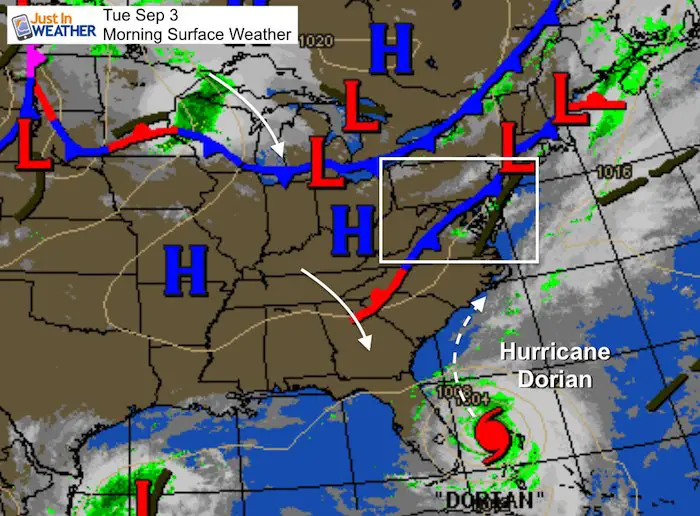
Morning Surface Map
It’s the front that brought us storms last night and the next one in the Great Lakes that will lift Dorian to the north. Meanwhile, we will warm up into the 80s today and close to 90ºF Wednesday. Then some storms will bring in cooler air and help to steer Dorian possible with landfall and then off of the coast near North Carolina.
Local Weather
Morning Temperatures

Afternoon Highs Today

Afternoon Highs Wednesday

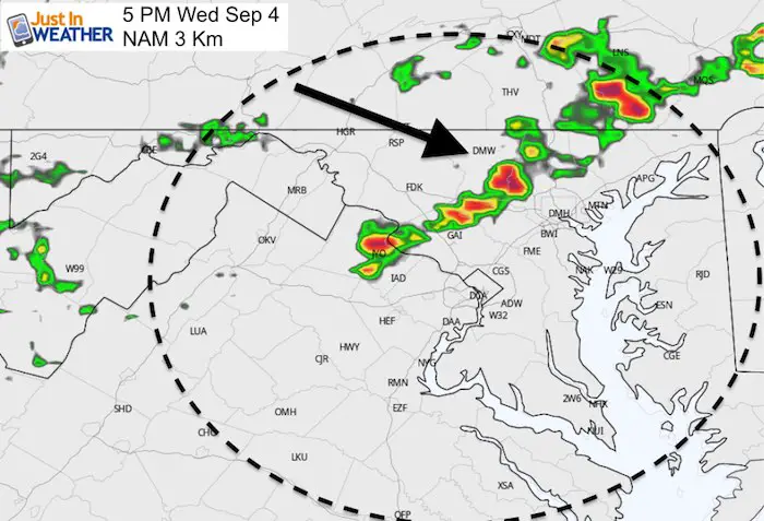
Afternoon Storms Wednesday
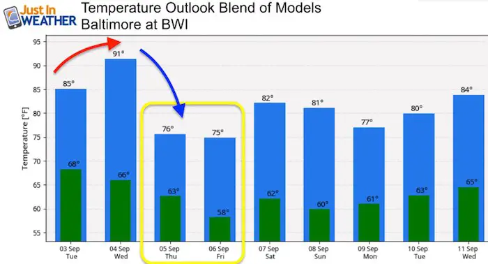
Temperature Outlook
After two warm/hot days, the end of the work week will be cooler in the 70s. This may include rain on Friday as Dorian pulls in the cooler air while it moves off of the coast.
Hurricane Dorian IR Satellite
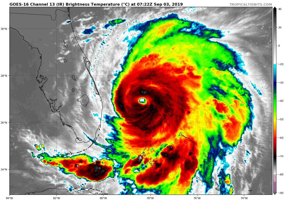
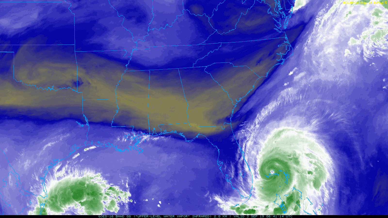
SUMMARY OF 500 AM EDT...0900 UTC...INFORMATION ---------------------------------------------- LOCATION...26.9N 78.4W ABOUT 35 MI...55 KM NE OF FREEPORT GRAND BAHAMA ISLAND ABOUT 105 MI...170 KM E OF WEST PALM BEACH FLORIDA MAXIMUM SUSTAINED WINDS...120 MPH...195 KM/H PRESENT MOVEMENT...STATIONARY MINIMUM CENTRAL PRESSURE...950 MB...28.06 INCHES Helping Dorian Move This is the Water Vapor Satellite. The brown shows the dry air with the trough digging into Florida. This moving south will help Dorian move northForecast Maps
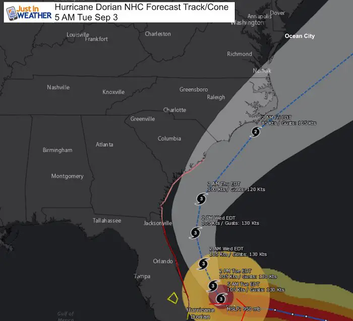
Compare European ECWMF to GFS Both models show rain getting into Southern Maryland on Friday. The European model is slower, but does bring the rain up possibly to Baltimore. The GFS Model is faster, cuts the rain south of the Bay Bridge, but brings stronger outer bands into Ocean City
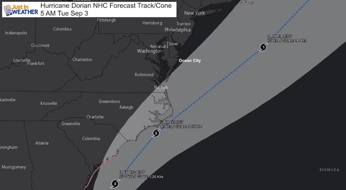
Tracking AWAY from the Mid Atlantic. The onshore winds and sloshing water will push north of the center.There is still concern for some surge into the Southern Chesapeake Bay and erosion on the beaches to Ocean City and Delaware.
SUMMARY OF WATCHES AND WARNINGS IN EFFECT:

A Storm Surge Warning is in effect for...
* Lantana FL to Savannah River

A Storm Surge Watch is in effect for...
* North of Deerfield Beach FL to south of Lantana FL
* Savannah River to South Santee River SC

A Hurricane Warning is in effect for...
* Grand Bahama and the Abacos Islands in the northwestern Bahamas
* Jupiter Inlet FL to Ponte Vedra Beach FL

A Hurricane Watch is in effect for...
* North of Deerfield Beach FL to Jupiter Inlet FL
* North of Ponte Vedra Beach FL to South Santee River SC

A Tropical Storm Warning is in effect for...
* North of Deerfield Beach FL to Jupiter Inlet FL
* North of Ponte Vedra Beach FL to Altamaha Sound GA

A Tropical Storm Watch is in effect for...
* North of Golden Beach FL to Deerfield Beach FL
* Lake Okeechobee
Keep In Touch Every Day
Just in case you don’t get all posts on your social media feed, stay up to date with the latest info…
Click here to sign up for email alerts…. Be the first to hear any new weather
Thank you to our Title Sponsor for Maryland Trek 6
Shining on with Smyth and their contribution, our team has raised over $95,000 for Just In Power Kids to provide free programs for kids in and post cancer treatment.

Please share your thoughts, best weather pics/video, or just keep in touch via social media
-
Facebook: Justin Berk, Meteorologist
-
Twitter: @JustinWeather
-
Instagram: justinweather
Maryland Trek Cycle Jerseys From Hill Killer
All proceeds will go to the Maryland Trek 6 total and Just In Power Kids programs

Just In Power Kids:
Proceeds go to our programs Providing FREE holistic care for kids in cancer treatment and up to 5 years post treatment and caregivers.
![]()
Shine On
Proceeds from all sales go to Just In Power Kids. Click the image to shop and show your support.

Love Maryland Shirts and Hoodies
This shirt was designed by my ‘bonus’ daughter Jaiden. The hoodie has been the biggest hit, so our promotion has been extended until the end of this week.
|
||
|
Show your love for Maryland and make this 14 year old artist and her mom extra proud
|


Related Links:
Was Your County Not Included?
Click this map for more on the regional forecast zones
