Friday August 30 2019
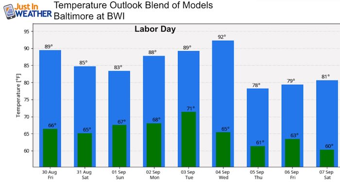
Our weather will be quiet and warming up as we enter the Labor Day weekend. Afternoon showers and some storms will build Sunday and Monday. But the big story will be Hurricane Dorian and its approach towards Florida. While the direct impact will be far away, the forces keeping it way will keep rip currents on local beaches through the holiday.
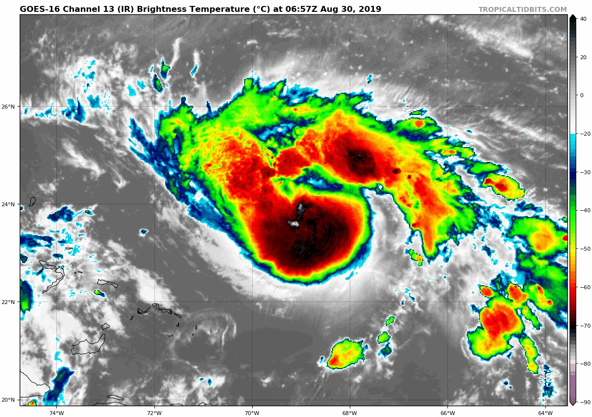
Hurricane Dorian Satellite
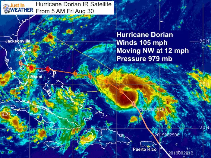
As of this morning, the storm had winds of 105 mph. That is a Category 2, but it likely will strengthen to Cat 3 today and then off to the races as it turns towards Florida. The forward movement is slowing down, making the expected landfall is a little later. This would allow more strengthening. The added concern is that there could be a chance for it to stall and crawl along the coast. More details and forecast maps below.
Local Weather
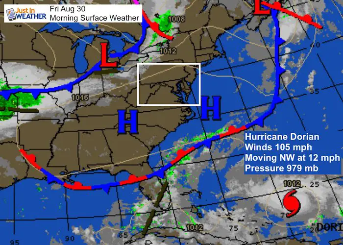
Today and Saturday will be dry with warm afternoons. But that cold front will increase our clouds and chance for afternoon storms Sunday and Monday. It’s that front that will help try and steer Hurricane Dorian into south central Florida.
Local Weather Stats:
Thursday August 29, 2019 in Baltimore
Average High: 83ºF
Record High: 101ºF in 1953
Average Low: 63ºF
Record Low: 45ºF in 1986
Sunrise: 6:32 AM
Sunset 7:40 PM
*Daylight = 2:25 shorter than yesterday
*Bay Water Temperature = 77ºF at Thomas Pt. Light House
Keep In Touch Every Day
Just in case you don’t get all posts on your social media feed, stay up to date with the latest info…
Click here to sign up for email alerts…. Be the first to hear any new weather
Thank you to our Title Sponsor for Maryland Trek 6
Shining on with Smyth and their contribution, our team has raised over $95,000 for Just In Power Kids to provide free programs for kids in and post cancer treatment.

Morning Temperatures
 Outlook
- Friday: Sunny
- Saturday: Partly Cloudy
- Sunday: Afternoon storms west and north (30%)
- Monday: Afternoon storms (60%)
Hurricane Dorian
The Satellite shows a healthy and larger storm. The tropical storm force winds (over 39 mph) extend 105 miles from the center. The hurricane force winds reach 25 miles out.
SUMMARY OF 500 AM AST...0900 UTC...INFORMATION
----------------------------------------------
LOCATION...23.8N 69.1W
ABOUT 260 MI...420 KM ENE OF THE SOUTHEASTERN BAHAMAS
ABOUT 530 MI...850 KM E OF THE NORTHWESTERN BAHAMAS
MAXIMUM SUSTAINED WINDS...105 MPH...165 KM/H
PRESENT MOVEMENT...NW OR 320 DEGREES AT 12 MPH...19 KM/H
MINIMUM CENTRAL PRESSURE...979 MB...28.91 INCHES
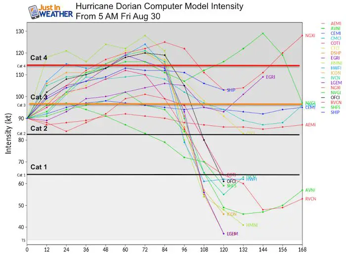
Forecast Intensity
This is almost a guarantee to be a Cat 3 today. That would make it a major hurricane, but likely to grow up to Cat 4 this weekend. That indicates winds over 130 mph.
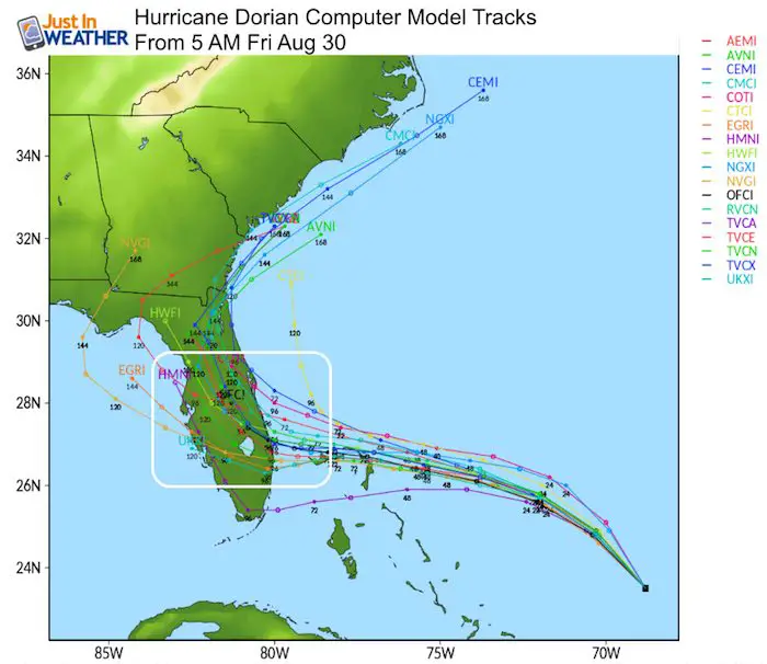
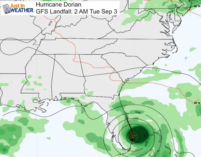
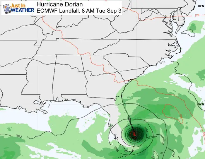
Forecast Tracks
All of the tracks and models here show landfall, but later in time. This is due to slowing of the forward movement. The trend to slow brings in the potential for this to possibly stall and crawl… making coastal impact across a wider area.
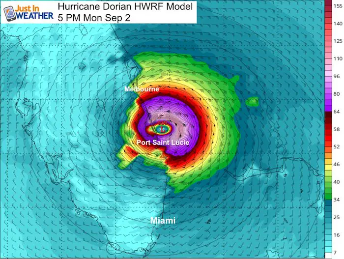
HWRF Forecast
High Resolution Hurricane Model
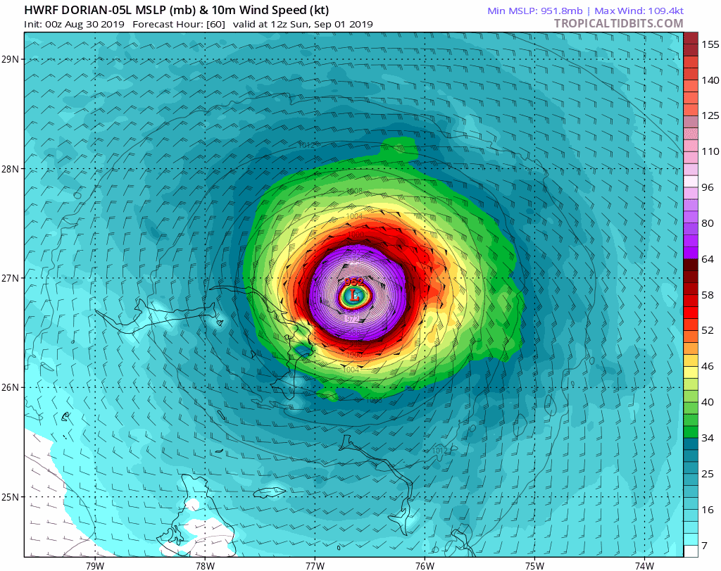
Potential Landfall:
At this time, the model shows Monday Evening between Port Saint Lucie and Melbourne
More Agreement With GFS and ECMWF (European) Models
Both models show a hit of the eye in southeast Florida near or just north of West Palm Beach. The timing is off by 6 hours, but both now pushed back to Tuesday morning.
 |
 |
National Hurricane Center Forecast
This shows landfall around Tuesday morning, a definite delay from the original expectation of Sunday. Please note that the continued change of timing and track is likely to continue to change a little. We will have more information now with hurricane hunters. The impact will cover a large area with rain overnight 12 inches, plus storm surge. So there is more beyond the winds to consider.
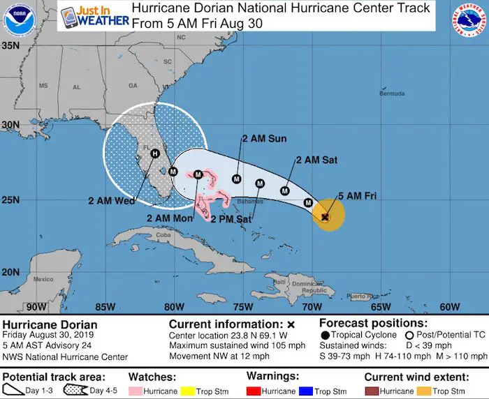
SUMMARY OF WATCHES AND WARNINGS IN EFFECT:

A Hurricane Watch is in effect for...
* Northwestern Bahamas

Watches for Florida are likely to be implemented today along with suggested evacuations.
Please share your thoughts, best weather pics/video, or just keep in touch via social media
-
Facebook: Justin Berk, Meteorologist
-
Twitter: @JustinWeather
-
Instagram: justinweather
Maryland Trek Cycle Jerseys From Hill Killer
All proceeds will go to the Maryland Trek 6 total and Just In Power Kids programs

Just In Power Kids:
Proceeds go to our programs Providing FREE holistic care for kids in cancer treatment and up to 5 years post treatment and caregivers.
![]()
Shine On
Proceeds from all sales go to Just In Power Kids. Click the image to shop and show your support.

Love Maryland Shirts and Hoodies
This shirt was designed by my ‘bonus’ daughter Jaiden. The hoodie has been the biggest hit, so our promotion has been extended until the end of this week.
|
||
|
Show your love for Maryland and make this 14 year old artist and her mom extra proud
|


Related Links:
Was Your County Not Included?
Click this map for more on the regional forecast zones
