Thursday August 29 2019
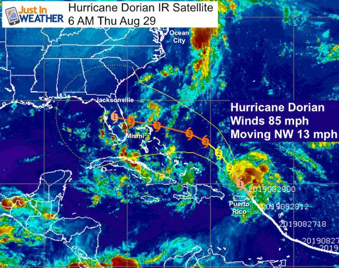
The big weather news is all about Hurricane Dorian and likely impact on the Southeast US this Labor Day weekend. It will be a focus as set up a warm and dry start to our holiday weekend. I will cover both aspects here, but let’s start with the storm that just hit the Virgin Islands but spared Puerto Rico from its worst. The center of Dorian stayed east of Puerto Rico passing over St. Thomas yesterday. It has kept on the right side of forecast tracks.
This morning, Hurricane Dorian has winds of 85 mph. It is entering warmer water and consensus forecasts show it becoming a major hurricane before reaching Florida this weekend. The would be Category 3 with winds of 115 mph or higher.
The complete hurricane forecast with the latest satellite loop are below our local weather:
Hurricane Dorian IR Satellite
Local Weather
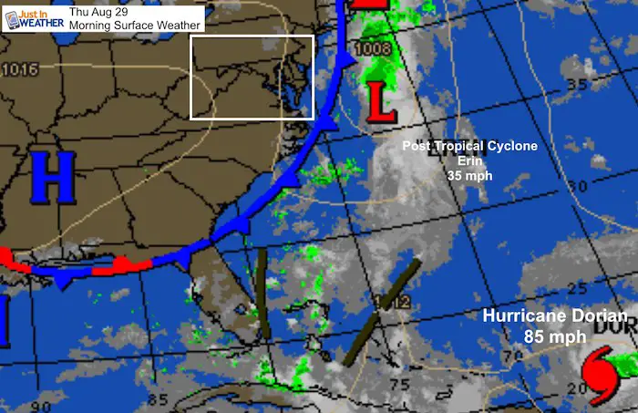
The rain we had yesterday was part of a cold front that will actually warm us back to late summer temps. Erin has been downgraded to a Post Tropical Cyclone with 35 mph winds. The front will keep it away from the coast, but rip currents will remain an issue at beaches through tomorrow.
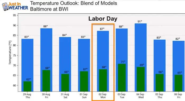
Our weekend will be warm with increasing chance of storms Sunday and Labor Day Monday afternoons and evenings.
Local Weather Stats:
Thursday August 29, 2019 in Baltimore
Average High: 83ºF
Record High: 100ºF in 1953
Average Low: 63ºF
Record Low: 47ºF in 1986
Sunrise: 6:32 AM
Sunset 7:42 PM
*Daylight = 2:26 shorter than yesterday
*Bay Water Temperature = 77ºF at Thomas Pt. Light House
Keep In Touch Every Day
Just in case you don’t get all posts on your social media feed, stay up to date with the latest info…
Click here to sign up for email alerts…. Be the first to hear any new weather
Thank you to our Title Sponsor for Maryland Trek 6
Shining on with Smyth and their contribution, our team has raised over $95,000 for Just In Power Kids to provide free programs for kids in and post cancer treatment.

Morning Temperatures
Afternoon Highs Today

Morning Lows Friday

Afternoon Highs Friday

Outlook
We can expect showers and thunderstorms to develop both Sunday and Monday afternoon to evening. More on that as we get closer.
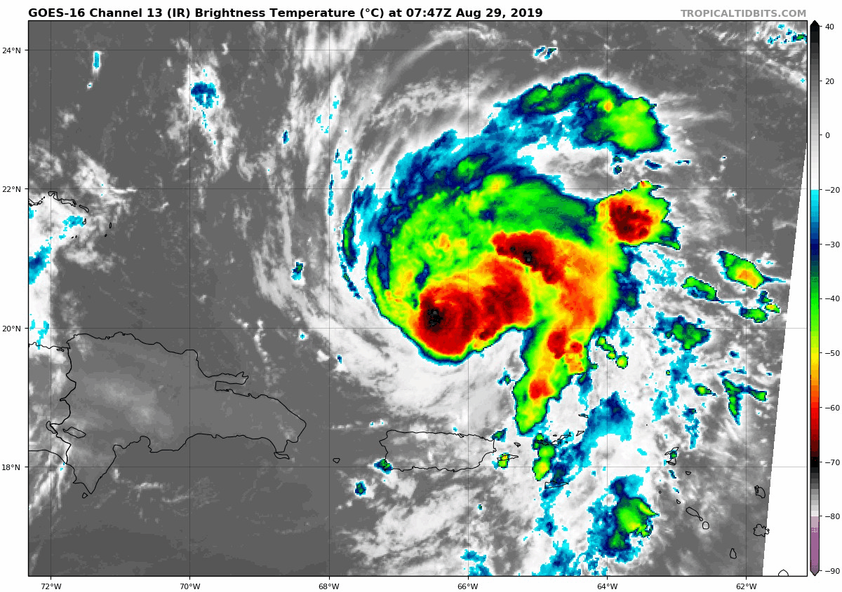
Hurricane Dorian
Infrared Satellite Loop
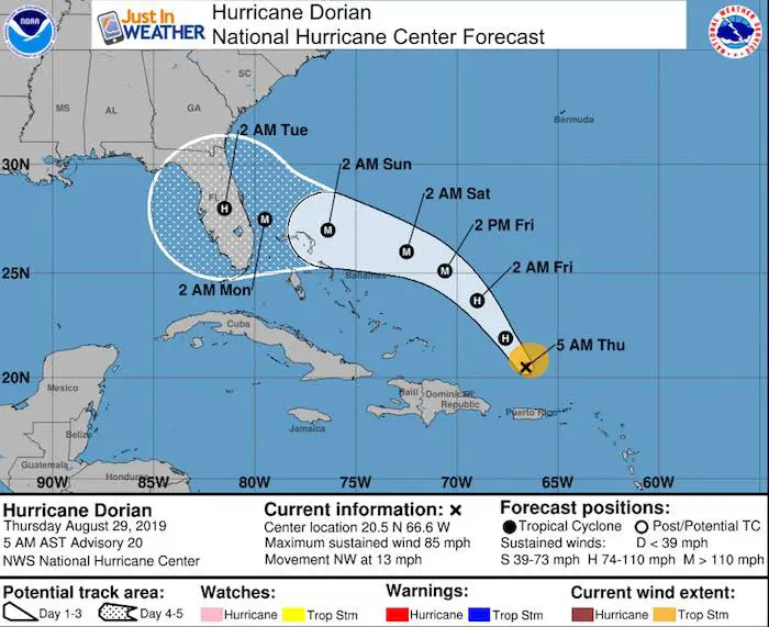
Hurricane Dorian Stats at 5 AM Thursday
LOCATION...20.5N 66.6W
ABOUT 150 MI...240 KM NNW OF SAN JUAN PUERTO RICO
ABOUT 425 MI...685 KM ESE OF THE SOUTHEASTERN BAHAMAS
MAXIMUM SUSTAINED WINDS...85 MPH...140 KM/H
PRESENT MOVEMENT...NW OR 325 DEGREES AT 13 MPH...20 KM/H
MINIMUM CENTRAL PRESSURE...991 MB...29.27 INCHES
Computer Model Forecast
There is a big spread in where landfall may occur on Sunday. To illustrate this, compare these two leading computer models. The GFS is farthest to the north. The European ECMWF is farthest to the south.
 |
 |
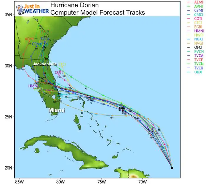
Hurricane Dorian Spaghetti Plot
Here is a look at the complete model forecast spread. The general agreement has landfall in the central Florida Atlantic coast. The would be south of Cape Canaveral… Eventually turning to the north. There is less agreement as to where that will happen before landfall, over Florida, or even after it enters the Gulf of Mexico.
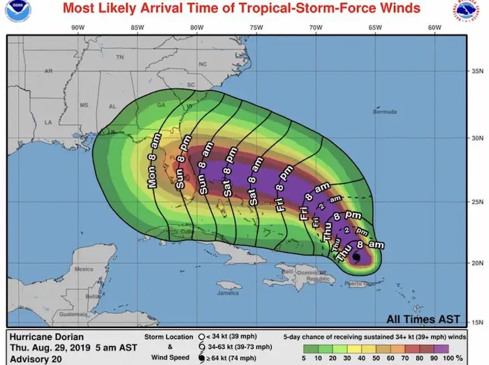
Hurricane Dorian Wind Arrival
Here is a plot of when Tropical Storm Intensity Winds (39 mph+) arrive. Sunday morning will be when the Florida coast will feel the first effects. Due to the forecast movement slowing down, the landfall is expected to be later on Monday.
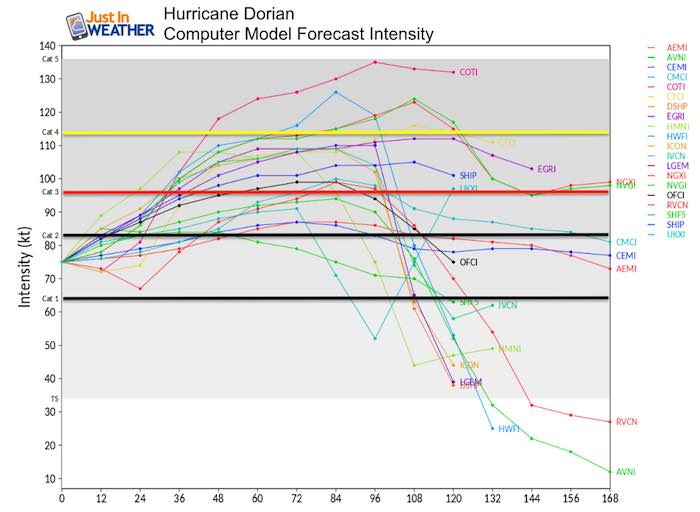
Hurricane Dorian Forecast Intensity
The majority of models show Dorian above Category 3 by tomorrow (hour 36). Notice there are models in this group that vary on both the strong and weaker side. It is important to note that so far the forecasting for this storm has NOT been good. The location of the center has been on the right or north side of forecasts.
National Hurricane Center Forecast
While the error in recent forecast has been to the north, the latest modeling shifts the landfall to the south. The confidence is on the lower side of moderate for timing and intensity. That is often the case with the first big event of the season. If you have interests in Florida, there is likely to be some wiggle room with the landfall. So please keep checking on the updates every 3 to 6 hours.
Please share your thoughts, best weather pics/video, or just keep in touch via social media
-
Facebook: Justin Berk, Meteorologist
-
Twitter: @JustinWeather
-
Instagram: justinweather
Maryland Trek Cycle Jerseys From Hill Killer
All proceeds will go to the Maryland Trek 6 total and Just In Power Kids programs

Just In Power Kids:
Proceeds go to our programs Providing FREE holistic care for kids in cancer treatment and up to 5 years post treatment and caregivers.
![]()
Shine On
Proceeds from all sales go to Just In Power Kids. Click the image to shop and show your support.

Love Maryland Shirts and Hoodies
This shirt was designed by my ‘bonus’ daughter Jaiden. The hoodie has been the biggest hit, so our promotion has been extended until the end of this week.
|
||
|
Show your love for Maryland and make this 14 year old artist and her mom extra proud
|


Related Links:
Was Your County Not Included?
Click this map for more on the regional forecast zones
