Wednesday August 28 2019
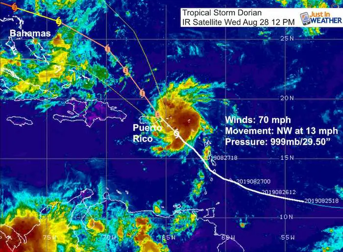
Tropical Storm Dorian is one of two active storms now in the Atlantic Basin but getting all of the attention. Erin is disorganized off the east coast and will stay away. Dorian currently has winds of 70 mph and Hurricane Watch has been issued for Puerto Rico.
UPDATED: Dorian was upgraded to Hurricane with 75 mph at 2 PM. I will make a new post this evening.
The storm could reach the US East Coast as a major hurricane according to the latest tropical forecast. That would be Category 3 with winds of 115 mph pr higher. We have seen rapidly developing storms quite a bit in the past few years, so it’s worth the attention. There will be a lot of media hype over this storm that may suck the air out of the room. But some of it is justified.
Here is a look at the storm and why we in the Mid Atlantic also need to pay attention for next week. The forecast intensity and track animations are below.
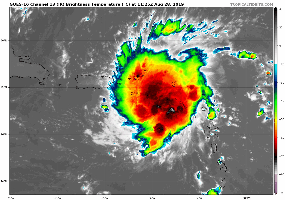
Tropical Storm Dorian IR Satellite
(animated loop below)
IR Satellite Loop
The center of the convection (highest cloud tops and heaviest rain) keeps getting displaced and appears to shift the storm to the north and east. That is what has caused prior forecasts to be wrong. The worst should miss Puerto Rico but hitting the US and British Virgin Islands.
Tropical Notes:
Dorian is the first real tropical threat to the US this season. Like many other storms, there is and will be adjustment with each model run every 6 hours. Technology has improved our forecasting skill, but it is not good too far out in time.
Why is that important? So far, the short range forecasting on this storm has been poor. Two days ago this was to pass west of Puerto Rico and weaken to a depression before reaching Florida. Today it is on track to pass on the east side of Puerto Rico, changing the entire track to miss the bulk of the Bahamas and be in an area with warmer water and less wind sheer.
The result: Now the forecast shows Dorian to become a hurricane tomorrow and grow to a Category 3 Major Hurricane this weekend. That would bring winds of 115 mph or higher when it approaches the Florida Coast.
National Hurricane Center Tropical Storm Dorian Forecast Track
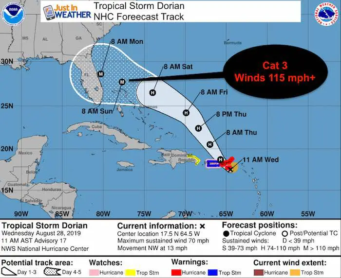
A Hurricane Warning is in effect for...
* Vieques and Culebra
* U.S. Virgin Islands
* British Virgin Islands

A Hurricane Watch is in effect for...
* Puerto Rico

A Tropical Storm Warning is in effect for...
* Puerto Rico

A Tropical Storm Watch is in effect for...
* Dominican Republic from Isla Saona to Samana
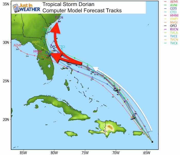
The computer model spread does not all agree. In fact the newly upgraded GFS Model is one of the forecasts that stop Dorian off the the Florida coast and turns it north into the Carolinas. That is where it gets interesting…
If it reaches Florida, landfall would be Monday or Tuesday. If it turns up the coast, then it could be Wednesday to Friday… and could impact the Mid Atlantic.
The Forecast Intensity also has a wide spread, and this all depends on the location, when it reaches land, water temperature, and wind sheer.
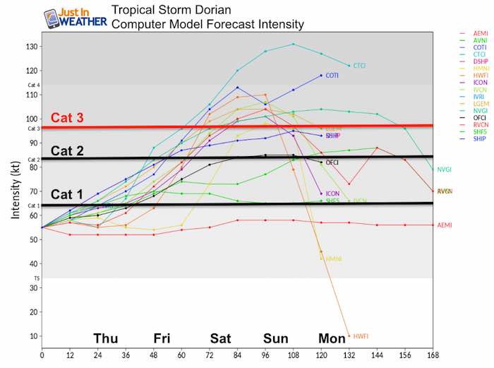
Where will it go?
Compare Two Model Forecast Animations…
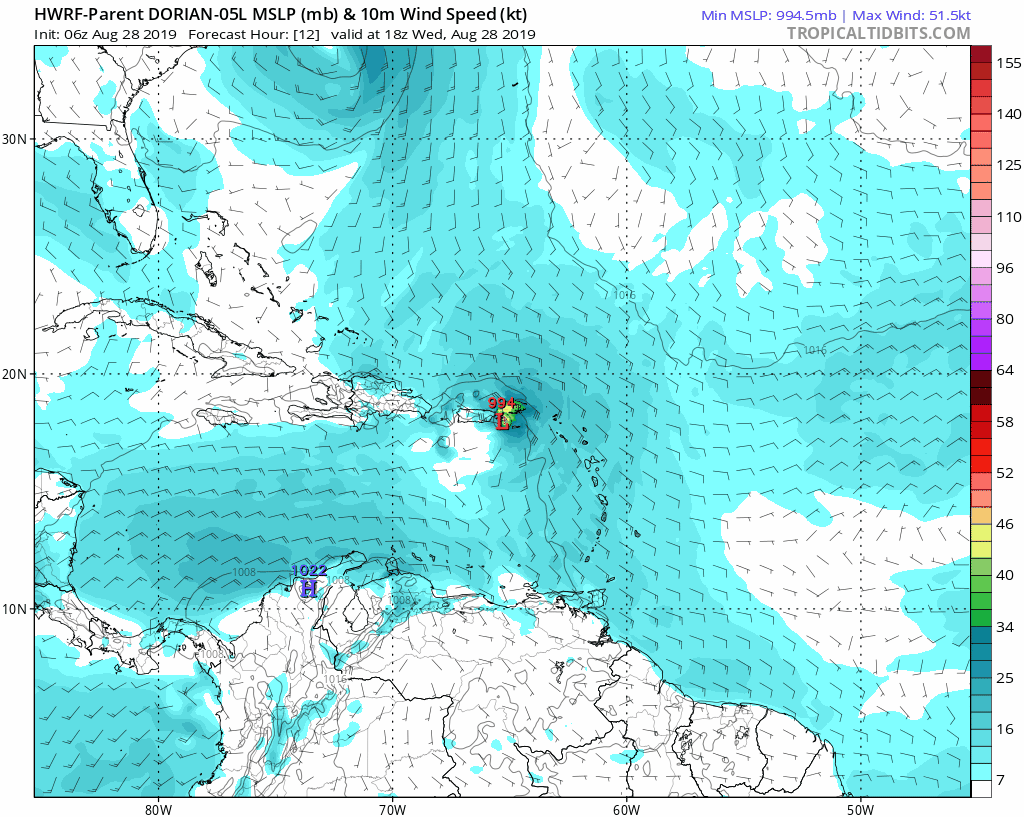
HWRF
This is the model matching the National Hurricane Center forecast. This takes the storm into Florida near Daytona Beach.
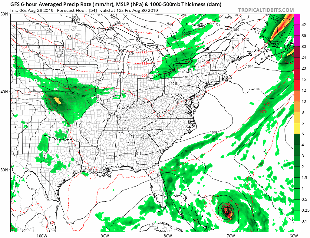
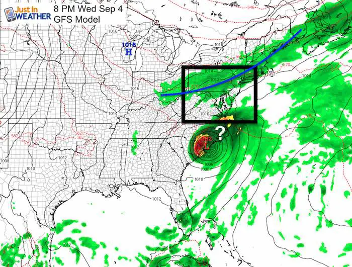
GFS Model
This is the model with the very expensive upgrade recently and is in the camp with the storm turning north and reaching South and North Carolina. Note the forecast for that is next Wednesday and Thursday. Unreliable at this point since the turn would be based on a cold front to kick it out to sea.
Also note: The tropical models have already been shown to be wrong in the short term this week. Once we get more frequent Recon Flights into the storm, then the model will be more reliable with more data to chew on.
See key time frames and notes below
Key Time Frames
Sunday Evening: This is where the GFS shows then Hurricane Dorian turning away from Florida and up the coast. This is where the HWRF has it making landfall on a due west track.
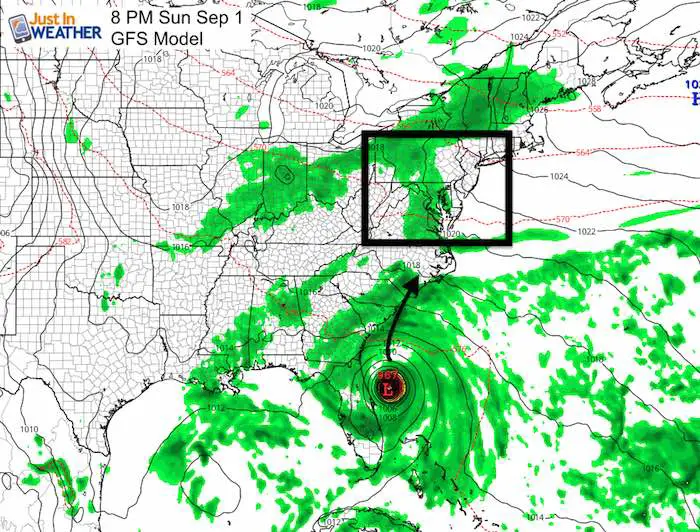
Next Wednesday Evening: This shows the core of Dorian already making landfall in SC and crossing eastern NC heading out to the Atlantic.
I put the question mark on the map since that is based on the timing and location of the cold front shown in PA. If the timing is off, Dorian could turn east sooner, or not at all and get pulled farther north into our area.
It is TOO FAR AWAY to make any certainty out of this. I just want to state these are distinct possibilities.
Please share your thoughts, best weather pics/video, or just keep in touch via social media
-
Facebook: Justin Berk, Meteorologist
-
Twitter: @JustinWeather
-
Instagram: justinweather
Keep In Touch Every Day
Just in case you don’t get all posts on your social media feed, stay up to date with the latest info…
Click here to sign up for email alerts…. Be the first to hear any new weather
Thank you to our Title Sponsor for Maryland Trek 6
Shining on with Smyth and their contribution, our team has raised over $95,000 for Just In Power Kids to provide free programs for kids in and post cancer treatment.

Maryland Trek Cycle Jerseys From Hill Killer
All proceeds will go to the Maryland Trek 6 total and Just In Power Kids programs

Just In Power Kids:
Proceeds go to our programs Providing FREE holistic care for kids in cancer treatment and up to 5 years post treatment and caregivers.
![]()
Shine On
Proceeds from all sales go to Just In Power Kids. Click the image to shop and show your support.

Love Maryland Shirts and Hoodies
This shirt was designed by my ‘bonus’ daughter Jaiden. The hoodie has been the biggest hit, so our promotion has been extended until the end of this week.
|
||
|
Show your love for Maryland and make this 14 year old artist and her mom extra proud
|


Related Links:
Was Your County Not Included?
Click this map for more on the regional forecast zones
