Friday May 31 2019
There is a lot of information to catch up on and even more photos and videos to sort through. Thank you all for sharing and I truly hope my forecast and reports help you be aware and prepare.
The results the two storms in Harford and Baltimore Counties on Wednesday is posted below in full. With 80 to 90 mph winds, both locations had a macroburst, not a tornado.
We’ve had an active week and today will be a break in the weather to survey the damage of the most recent Howard County Tornado.
Note: This is the same storm that came out of Frederick MD that produced street flooding. This from Jennifer Goedert Sunday

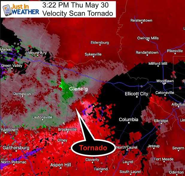
Doppler Radar plus video has confirmed that at 3:20 PM a tornado had touched down in Glenelg Maryland. The National Weather Service will be sending out a team to survey the damage today. They will determine the intensity of the winds, level on the EF scale, and path.
The Velocity Scan of Doppler Radar shows the rotation hook and funnel.
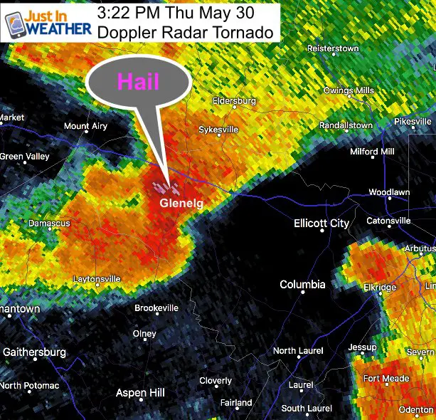
The Doppler Radar standard return you are use to seeing shows that hail fell to the north, which is often on a different side of the storm cell.
Photos
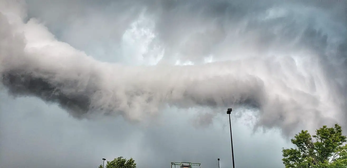
There has been an incredible about of photos with these storms. I am still sorting through them. Here is the clouds reaching Columbia but the Target Thanks to Kris Ann.
Please see more in the comments and posted by others on my FB page wall:
-
Facebook: Justin Berk, Meteorologist
Here is JP Arnold capturing what he believes was the tornado touching down within a 100 yards of him pulling over
Wednesday Storm Survey Report
Macroburst with 80 to 90 mph winds hit Harford County and Baltimore County
From NWS
...NWS STORM SURVEY RESULTS FOR BALTIMORE AND HARFORD COUNTIES
MARYLAND FROM STORMS OCCURRING ON WEDNESDAY MAY 29 2019...

Staff from the National Weather Service Baltimore/Washington
Weather Forecast Office completed storm surveys in portions of
the northern Baltimore Metropolitan Area on Wednesday afternoon,
May 29, 2019.

The Fallston and Baldwin area of west-central Harford County was
impacted by a macroburst, which produced damaging wind gusts
estimated at 80-90 MPH. A macroburst is defined by Fujita
(University of Chicago, 1985) as a large downburst with winds
extending in excess of 2.5 miles long. A concentrated area of
damage was observed starting at Moores Road in Baldwin, extending
discontinuously for approximately 3.25 miles to the east, ending
at Pleasantville Road in Fallston. In this area, numerous
observations of tree damage were observed. The tree damage
included mainly large limbs of hardwood trees and snaps of about a
dozen pine trees. Several single family homes were impacted with
limbs falling onto rooftops. All tree damage fell in an easterly
direction, with eyewitness time estimates of occurrence between
600-615 PM. An image circulating among residents showed what
appears to be a roll cloud, representing the leading edge of the
gusty winds. Frequently, roll clouds are mistakingly identified as
a funnel cloud or a tornado, but they lack the laminar,
streamlined condensation cloud of a funnel cloud which would be
attached to the cumulus cloud base. Storm Relative Velocity at the
0.5 degree elevation angle from the FAA`s Terminal Doppler
Weather Radar at BWI Thurgood International Airport clearly shows
a divergent pattern at 610 PM across the region, indicative of a
downburst windfield, which coincides with time estimates by
eyewitnesses.

The other region of the northern Baltimore Metropolitan area that
was adversely impacted by Wednesday afternoon`s severe storms was
the White Marsh region of eastern Baltimore County. This area was
also impacted with a macroburst, which caused straight-line wind
damage. Two wooden telephone poles were snapped along Silver
Spring Road, and numerous trees and branches were downed along
Saxon Circle. All observed tree damage fell to the northeast.
Additionally, the Baltimore County Office of Homeland Security and
Emergency Management reported the easternmost wind damage in
Middle River, near the intersection of Ebenezer and Bird River
Roads. The western most damage reported was near the intersection
of Yvonne Ave and Silver Spring Rd in Nottingham. There were
approximately 18 instances of tree damage between these two
locations, with the horizontal distance of about 4 miles. The
FAA`s Terminal Doppler Weather Radar at BWI Thurgood International
Airport clearly shows a 0.5 degree elevation angle radial
velocity downburst/divergent wind pattern at 555 PM. The snapping
of the telephone poles and nature of the reported and observed
tree damage produces an estimate of 80-90 MPH wind.
Keep In Touch Every Day
Just in case you don’t get all posts on your social media feed, stay up to date with the latest info…
Click here to sign up for email alerts…. Be the first to hear any new weather.
Join My Team: Maryland Trek 6
Our look got an upgrade, but we have the same purpose. Please click the logo take a look at our new page.
- Consider joining our team for the week, a single day, or even as a sponsor.

Support Our Nonprofit:
Proceeds go to our programs Providing FREE holistic care for kids in cancer treatment and up to 5 years post treatment and caregivers.
![]()
Shine On
Proceeds from all sales go to Just In Power Kids. Click the image to shop and show your support.

Love Maryland Shirts and Hoodies
This shirt was designed by my ‘bonus’ daughter Jaiden. The hoodie has been the biggest hit, so our promotion has been extended until the end of this week.
|
||
|
Show your love for Maryland and make this 14 year old artist and her mom extra proud
|


Please share your thoughts, best weather pics/video, or just keep in touch via social media
-
Facebook: Justin Berk, Meteorologist
-
Twitter: @JustinWeather
-
Instagram: justinweather