Tuesday April 9 2019
If you were in the path of one of the strong or severe storms yesterday, there may be some fog this morning. You may also have a chance for another shower later today, but it will be less intense. The main story this morning is that it still feels very warm, and you will notice it when you step outside.

Evening Showers
There is a cold front that will be passing this evening. The band of showers that will develop will be scattered as it drops out of Pennsylvania between 2 and 5 PM. Then it will gain more traction, perhaps near Baltimore around 6 PM. Then on Maryland’s Eastern Shore between 7 and 9 PM. See the timeline slider below. Behind this the temperatures will be cooler as we dry out Wednesday and Thursday.
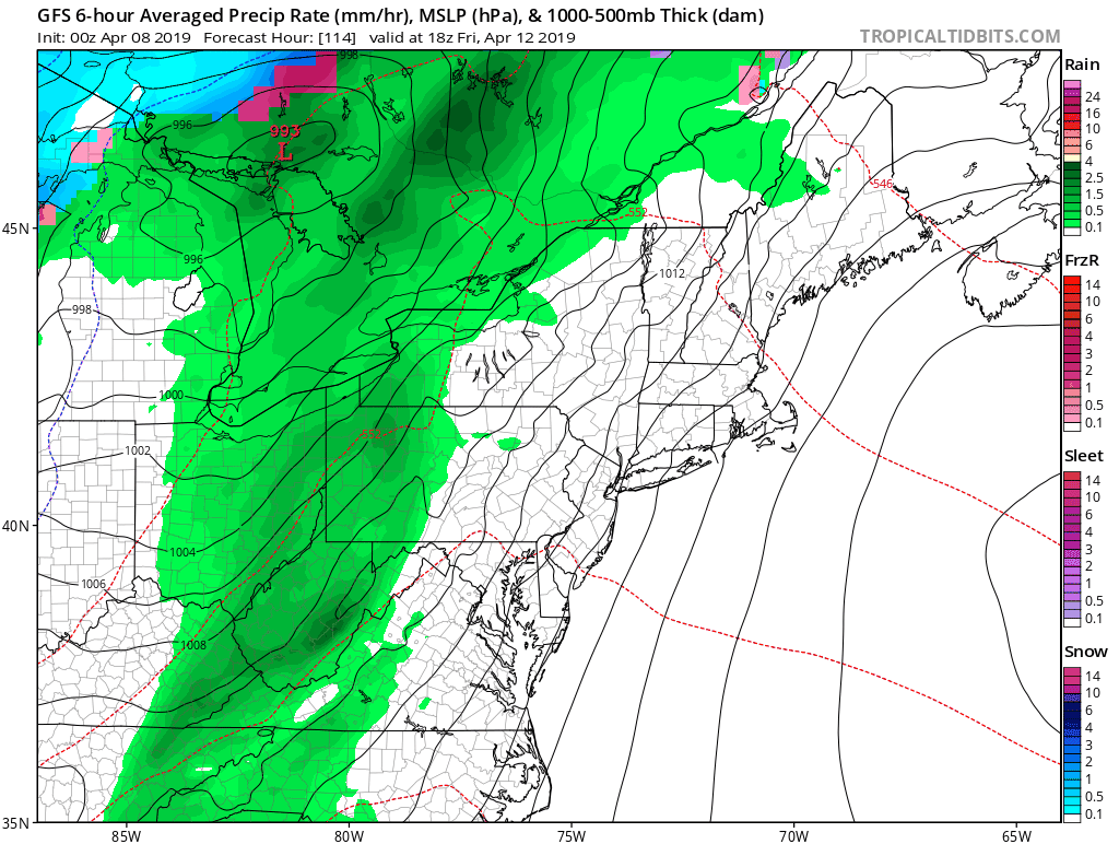
Weekend will have rain on the bookends. We could have some thunderstorms Friday afternoon, then a larger storm Sunday evening into Monday. See the maps below.
Local Weather Stats For April 9, 2019 in Baltimore
Average High: 62ºF
Record High: 89ºF in 1959
Average Low: 41ºF
Record Low: 26ºF in 2007
*Record Snow: = 3.0″ in 1917
Sunrise: 6:38 AM
Sunset 7:37 PM
*Daylight = 2:30 longer than yesterday
*Bay Water Temperature = 52ºF at Thomas Pt. Light House
Keep In Touch Every Day
Just in case you don’t get all posts on your social media feed, stay up to date with the latest info…
Click here to sign up for email alerts…. Be the first to hear any new weather.
Maryland Trek 6
Our look got an upgrade, but we have the same purpose. Please click the logo take a look at our new page.
- Consider joining our team for the week, a single day, or even as a sponsor.


New Partner
Buchanan Kia of Westminster is a supporter of Just In Power Kids and Maryland Trek 6 in August 2019.
High Temperatures Today

Rain Timeline —> slider
[metaslider id=75495]
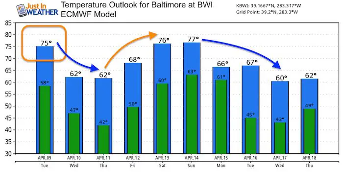
Wednesday Temperatures


Wednesday Blizzard
While we are definitely in Spring, a new strong storm will be raging on the northern Rockies and northern Plains.

Blizzard conditions are likely as well as the media reports overplaying the ‘bomb cyclone’ story. For what it’s worth, Dr. Ryan Maue has plotted the number of Bomb Cyclones since 1980. The cycle of activity shows there has been no discernible increase in numbers, just reporting on them.

Weekend Rain?
The outlook shows a chance for thunderstorms on Friday evening, then a larger storm for us Sunday evening into Monday.
Temperature Outlook
This model is a little cooler today, but the trend for lower 60s Wednesday and Thursday is supported by most model guidance. This weekend will warm again, then a larger cool down potentially next week.
Keep In Touch Every Day
Just in case you don’t get all posts on your social media feed, stay up to date with the latest info…
Click here to sign up for email alerts…. Be the first to hear any new weather.
Please share your thoughts, best weather pics/video, or just keep in touch via social media
-
Facebook: Justin Berk, Meteorologist
-
Twitter: @JustinWeather
-
Instagram: justinweather
Related Links:
Was Your County Not Included?
Click this map for more on the regional forecast zones
