Thursday March 7 2019
We are still in the deep freeze and the ground is cold. That is the one thing that brings us into this next snow event differently than last weekend. It will snow on Friday, mostly during the day. But it is March, and the sun angle plays a big role. If this was at night or earlier in winter we would have a nice little event on on hands. Instead, I think we need to look at last weekend for the locations and timing of how the snow was received on the ground.
First, let’s look at today’s weather

Morning Temperatures
Still very cold!

Local Weather Stats For March 7, 2019 in Baltimore
Average High: 51ºF
Record High: 76ºF in 1974
Average Low: 31ºF
Record Low: 6ºF in 2015
*Record Snow: = 10.0″ in 1941
Sunrise: 6:30 AM
Sunset 6:04 PM
*Daylight = 2:33 longer than yesterday
*Bay Water Temperature = 38ºF at Thomas Pt. Light House
Keep In Touch Every Day
Just in case you don’t get all posts on your social media feed, stay up to date with the latest info…
Click here to sign up for email alerts…. Be the first to hear any new weather.

New Partner
Buchanan Kia of Westminster is a supporter of Just In Power Kids and Maryland Trek 6 in August 2019.
This Afternoon

Before Tracking The Snow, Check Out The Temps In Friday
Friday Morning

Friday Afternoon

Friday Snow Timeline —> slider
- Notice the timing… After 9 AM
- Notice the Freezing Line
[metaslider id=74531]
How Much Snow?
Most of this will be on the grass or snowpack already in place

Notes:
It is important to consider the season. The higher sun angle does play a role warming the pavement. With temperatures near freezing, there may be some stickage at the start. The ground is already cold. But the solar angle should win the war in pavement.
How to Describe This:
I’ve been trying to come up with something that might help elaborate on this snow…
- More bark than bite
- Ambience snow
- Wet roads during the day
- Stickage on snowpack or grass
- *This might be an extra coating on the ski resorts
- More show and less glow
- Waste of flakes
Forecast Animation
After the Friday snow, rain will arrive Saturday night and end Sunday morning.
This is timing out to be a little earlier. It may be done before afternoon… and temperatures will be warming up.
![]()
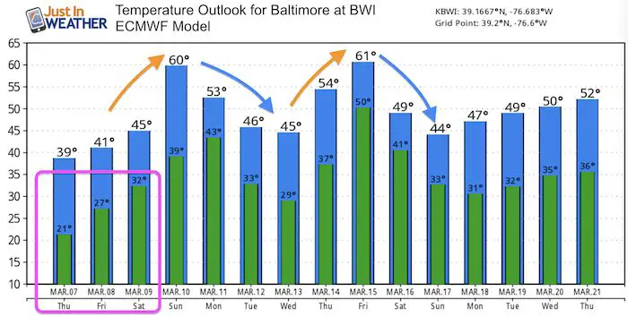
Temperature Outlook
ALL FITF Apparel

Please share your thoughts, best weather pics/video, or just keep in touch via social media
-
Facebook: Justin Berk, Meteorologist
-
Twitter: @JustinWeather
-
Instagram: justinweather

20% Off End Of Season Sale
Use PromoCode: lasthurrah20
New Colors
We are giving 10% of each sale to Just In Power Kids: Providing FREE holistic care for pediatric oncology patients.

Related Links:
Winter Outlook
My Winter Outlook 2018-19: Multiple Nor’Easters and more snow

Was Your County Not Included?
Click this map for more on the regional forecast zones

Interactive Snow Report
November 15 Snow Reports- Interactive Map Compared To My Forecast

Winter Snow And Top 5 Wet Years
Snowfall Seasons at Beginning and End of Top 5 Wet Years In Baltimore

Related Winter Outlooks
Solar Cycle: When Sun Spots Are Low We Get More Snow
El Nino Modoki May Enhance Snow Chances
Sweet Spot: Hitting 70ºF on Halloween is followed by more winter snow
Will A Wet Summer Bring A Snowy Winter?
NOAA Winter 2018-2019 Outlook Explained: This Actually Supports Snow
Winter Outlook From Two Different Farmers Almanacs
Maryland Winters: Snowfall Maps and Baltimore Snow History
