Saturday March 2 2019
Last night I was out with my family on the north end of our region and we drove through freezing rain around 9 PM. Shortly after I posted this on my Facebook page, it turned to sleet. Overnight the colder air won and snow reached southward into central Maryland and across to northern Delaware. I was hoping this particular event would not play out, but our place isa month the many that got 3 inches of fresh powder and this morning. I am on my way to shovel after posting this report.
There is still ice in the region that was under a Winter Weather Advisory. Here are the temperatures at 6 AM.

This system is moving out, and we will get to thaw back into the 40s this afternoon. A break before our next storm Sunday afternoon. See more on the Winter Storm Watch below.

Local Weather Stats For March 2, 2019 in Baltimore
Average High: 49ºF
Record High: 80ºF in 1972
Average Low: 30ºF
Record Low: 13ºF in 1980
*Record Snow: = 4.7″ in 2009
Sunrise: 6:38 AM
Sunset 5:59 PM
*Daylight = 2:32 longer than yesterday
*Bay Water Temperature = 39ºF at Thomas Pt. Light House
Keep In Touch Every Day
Just in case you don’t get all posts on your social media feed, stay up to date with the latest info…
Click here to sign up for email alerts…. Be the first to hear any new weather.

New Partner
Buchanan Kia of Westminster is a supporter of Just In Power Kids and Maryland Trek 6 in August 2019.
This Afternoon- A chance to melt some snow

Winter Storm Watch Sunday Morning Into Monday Morning
- At first glance, this looks like it will be just for the northern counties inland from Baltimore.
- The average snowfall will be 3 to 6 inches with some higher spots.
- But, there has been a colder trend to shift this southward. The models below show the snow trying to reach through the city.
- The bulk of the snow will fall Sunday afternoon and be done before Monday morning.

Storm Animation
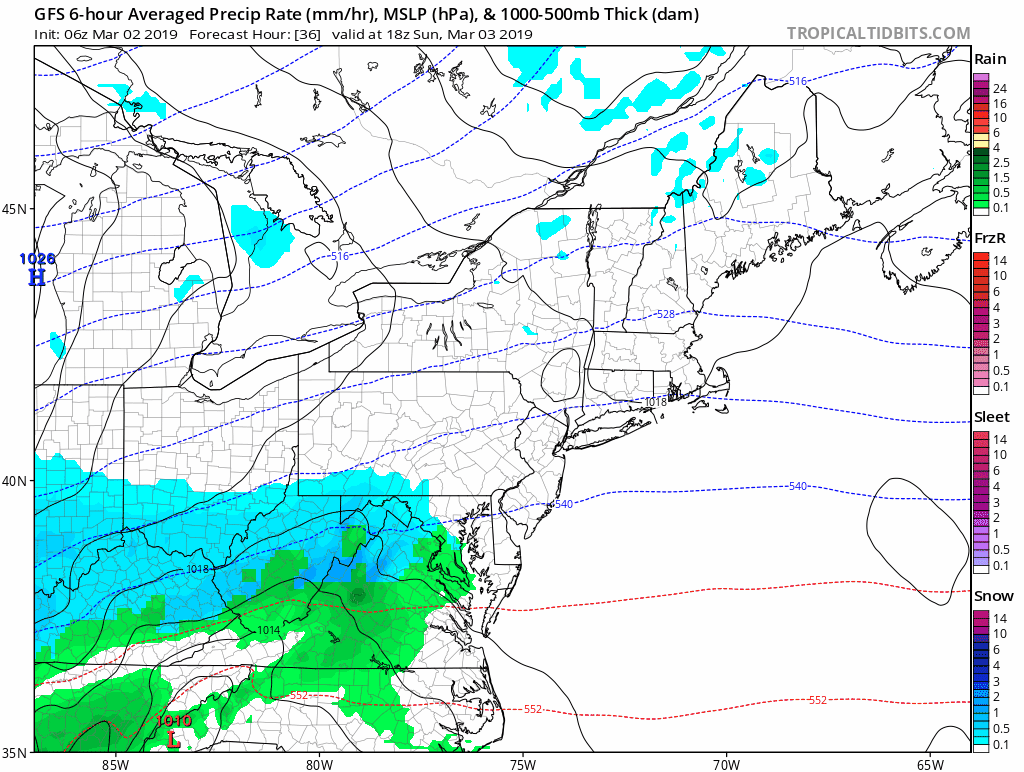
Compare The Models
GFS Model Timeline —> slider
This brings the snow through Washington and close to Annapolis
[metaslider id=74261]
European Model Timelines —> slider
This holds the snow line north of I-95 missing Washington and Annapolis. Baltimore would be right on the edge.
[metaslider id=74270]
NAM 3Km Snapshot
Notice the snow line is just north of Baltimore. This will once again be a very close call for the city. But like to be rain in southern Maryland.

Note: I am still in the middle of a big family weekend, so my updates will be limited. I do hope to have my call for to storm by Sunday morning before it begins.
Temperature Outlook
Very cold air will follow the storm… Wednesday will be when we bottom out. There is hope for a return to near and above average temps by the middle of the month.

ALL FITF Apparel

Please share your thoughts, best weather pics/video, or just keep in touch via social media
-
Facebook: Justin Berk, Meteorologist
-
Twitter: @JustinWeather
-
Instagram: justinweather

20% Off End Of Season Sale
Use PromoCode: lasthurrah20
New Colors
We are giving 10% of each sale to Just In Power Kids: Providing FREE holistic care for pediatric oncology patients.

Related Links:
Winter Outlook
My Winter Outlook 2018-19: Multiple Nor’Easters and more snow

Was Your County Not Included?
Click this map for more on the regional forecast zones

Interactive Snow Report
November 15 Snow Reports- Interactive Map Compared To My Forecast

Winter Snow And Top 5 Wet Years
Snowfall Seasons at Beginning and End of Top 5 Wet Years In Baltimore

Related Winter Outlooks
Solar Cycle: When Sun Spots Are Low We Get More Snow
El Nino Modoki May Enhance Snow Chances
Sweet Spot: Hitting 70ºF on Halloween is followed by more winter snow
Will A Wet Summer Bring A Snowy Winter?
NOAA Winter 2018-2019 Outlook Explained: This Actually Supports Snow
Winter Outlook From Two Different Farmers Almanacs
Maryland Winters: Snowfall Maps and Baltimore Snow History
