Friday March 1 2019
Today is the start of Meteorological Spring, but we are far from done with winter. This latest snow event brought an average of 2 inches to most places in our region. But the range is between 1 to 3 inches. How much did you get? Traffic this morning depends on what roads were treated, and the final burst of snow crossing Rt 50 and to the Eastern Shore. But most schools have been delayed and it will take some daylight and slow warming to help thaw the rest pavement.
There is more on the way! Some rain showers will linger south, but another push of winter weather will arrive this evening. The concern is mainly for there colder suburbs to the north through tonight. Then we shift our focus to another storm Sunday into Monday morning. Oh, but wait. There long range has yet another event possible next weekend.
Morning Radar Loop
Morning Temperatures
See the slow warming in the timeline below

Local Weather Stats For March 1, 2019 in Baltimore
Average High: 49ºF
Record High: 80ºF in 1972
Average Low: 29ºF
Record Low: 11ºF in 1980
*Record Snow: = 6.0″ in 1952
Sunrise: 6:39 AM
Sunset 5:58 PM
*Daylight = 2:32 longer than yesterday
*Bay Water Temperature = 39ºF at Thomas Pt. Light House
Keep In Touch Every Day
Just in case you don’t get all posts on your social media feed, stay up to date with the latest info…
Click here to sign up for email alerts…. Be the first to hear any new weather.

New Partner
Buchanan Kia of Westminster is a supporter of Just In Power Kids and Maryland Trek 6 in August 2019.
Slow Warming/Thawing
Temperature Timeline —> slider
[metaslider id=74147]
More Snow Tonight (Northern Suburbs into PA)
The HRRR Model brings it back after 7 PM

NAM Km Model Snow Timeline —> slider
[metaslider id=74162]
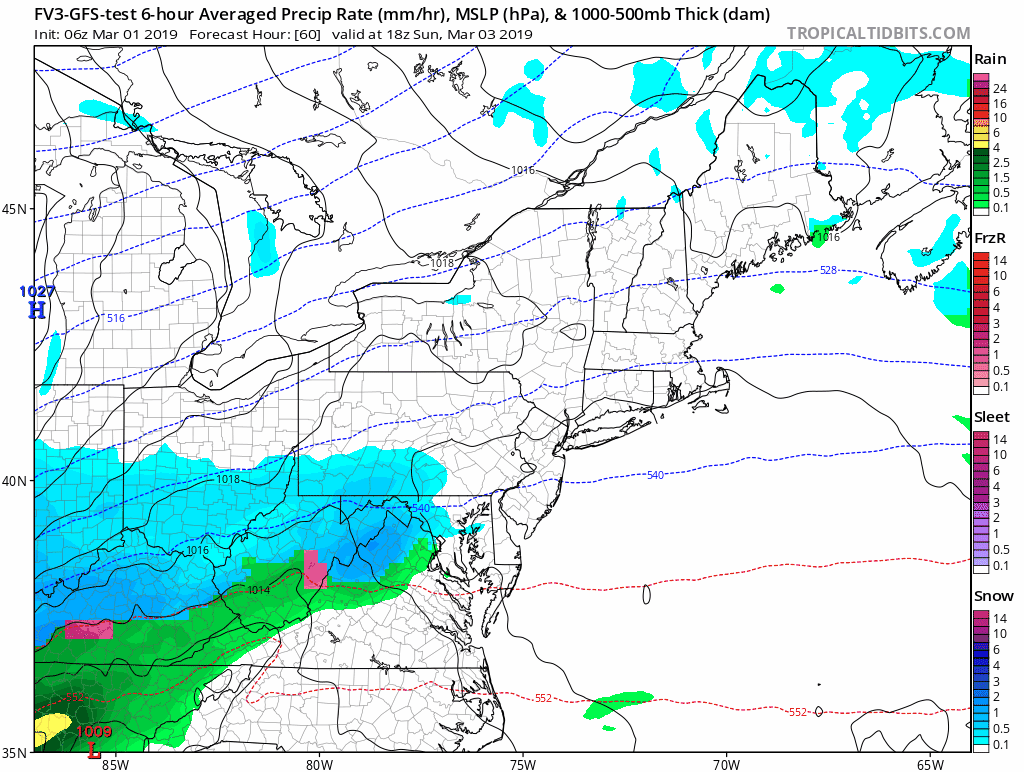
More Snow Sunday?
This next storm will follow a similar path, and be a little stronger. This is not a lock by any means… So we need to track this closely.
Please consider these notes then see the animations and two model snapshots below
- The rain/snow line will cut through our region. This is the hard part as to who will be affected.
- The European Model keeps the normally colder suburbs in the snow, but rain elsewhere.
- The American GFS Model shows snow for more of central Maryland
- Both show the freezing line north, so it may be a slushy snow with temps above freezing.
- Monday morning should turn colder, so it is possible to be wet then some freezing before schools open
Snapshots
American GFS shows more snow

European Model shows the snow line farther north

Let’s get through this morning’s clean up and I will have a better look at the return snow for tonight and this storm in my next report.
ALL FITF Apparel

Please share your thoughts, best weather pics/video, or just keep in touch via social media
-
Facebook: Justin Berk, Meteorologist
-
Twitter: @JustinWeather
-
Instagram: justinweather

20% Off End Of Season Sale
Use PromoCode: lasthurrah20
New Colors
We are giving 10% of each sale to Just In Power Kids: Providing FREE holistic care for pediatric oncology patients.

Related Links:
Winter Outlook
My Winter Outlook 2018-19: Multiple Nor’Easters and more snow

Was Your County Not Included?
Click this map for more on the regional forecast zones

Interactive Snow Report
November 15 Snow Reports- Interactive Map Compared To My Forecast

Winter Snow And Top 5 Wet Years
Snowfall Seasons at Beginning and End of Top 5 Wet Years In Baltimore

Related Winter Outlooks
Solar Cycle: When Sun Spots Are Low We Get More Snow
El Nino Modoki May Enhance Snow Chances
Sweet Spot: Hitting 70ºF on Halloween is followed by more winter snow
Will A Wet Summer Bring A Snowy Winter?
NOAA Winter 2018-2019 Outlook Explained: This Actually Supports Snow
Winter Outlook From Two Different Farmers Almanacs
Maryland Winters: Snowfall Maps and Baltimore Snow History
